

Stage 7 of the New Mexico Backcountry Discovery Route - Cuba to Colorado.
We'd entered Cuba from the south on NM-550, and we exited the same direction - though on different pavement - for the first 20 miles of the stage. Cuba then, is a stop for fuel - and a good one at that, as the price is quite reasonable - but not much more than that, route wise, anyway.

In 1769, Spanish Governor Pedro Fermin de Mendinueta made the San Joaquin del Nacimiento land grant to 35 pioneering families who had settled the headwaters of the Rio Puerco in 1766. The community was later abandoned, owing to raids by frontier Indian tribes, but was resettled in the late 1870s. Originally known as Nacimiento or La Laguna, it was renamed Cuba when the post office was established in 1887.
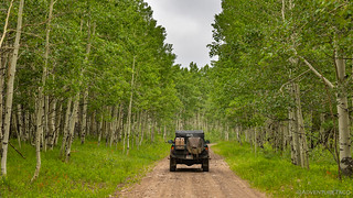
Eventually turning east, we entered the Carson National Forest to overcast skies full of "yep, it's still raining," clouds. We crossed our fingers that the rain would be light, that we would thread our way through it, or that at the very least, the roads would be rocky and drain well.

Maybe it'll clear up.

Once we hit dirt, it was immediately clear that dry roads were not in our future - puddles appearing almost immediately. What we didn't know at the time was that we were actually lucky with the condition of the roads, but we'll get to that in a second. A few miles in, we noticed a BMW SUV pulled over on the side of the road, its driver wandering around in that way that says, something's not quite right.
I slowed down and rolled down my window to ask if she was OK, and the look of relief on her face was palpable. Turns out that she'd been camped a little further up a side road with several of her friends, and she was pretty sure that they were stuck - she'd barely made it out due to the mud. Seeing our Tacoma, she was sure that they'd been saved.
That made one of us.
We got directions and names and let her know that we'd do our best as we headed into 5" deep muck that stuck to the tires before being flug every which way onto the sides and top of the truck.
Sure enough, a mile up the road, we ran into her friends. Two sedans and an F-150 pulling an airstream were bogged down in the middle of the road. Luckily, the lack of driving experience was a bigger factor to their situation than the lack of 4WD, and with a bit of coaching and some strategic wheel placement, I was able to get them moving quickly enough - and in the correct directions - to make it out, alive.
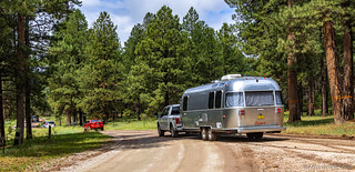
Our new friends, heading home full of thanks.
While helping them out, I asked how long it'd been raining and the F-150 owner told me it rained reasonably heavily all through the night, letting up around 8:30am - only a few hours before we arrived. I didn't know whether to count our blessings, or fear what was ahead. A little of both, I guess.

Headed back in the right direction, plenty of water still on the road.
For now, anyway, the sun was trying to force its way through the clouds, and we splashed through puddles and threw mud in the air as we made our way toward Teakettle Rock.

I suppose there's a teakettle in there somewhere. More interesting - to me - was this random rock sitting in a grassy field.
10:30am when we parked in the pullout at the rock, we took the opportunity to eat a late breakfast as we wandered around, looking for the best angle, and bah-humbugging about the various names and profanity etched into the rock's lower surfaces.
We only hung around as long as it took to finish our bowls of cereal, the thought of finishing the route now urging us on. Really, it'd likely come down to how much pavement this segment contained - as well as whether the weather held out. Only time would tell. For now, we enjoyed the views around us as we neared the Abiquiu Reservoir.

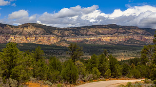
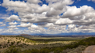
A striking range in the Carson NF.
There are likely countless ruins and rock art sites to explore. If only we were closer, and had the time.
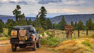
Feeding our - perhaps premature - thoughts of completion, the final 10 miles of our approach to the reservoir were paved. Few places was it more apparent how dire the drought situation was in New Mexico than at the Abiquiu Dam. In fact, though they were still releasing water into the river below the dam to drive the small 16.5MW power plant, the water levels were so low that the dam wasn't serving any purpose.

The dam is out of frame, to the left.

Note the two layers of material - the dam was raised by the Army Corps of Engineers in 1986. It has never filled beyond 30% capacity.
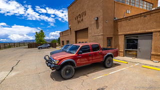
As a side note, we found a perfectly nice 1st gen parked inside the dam gates. Can the internet find its owner?
From the dam, the BDR split. The normal route traversed down the downstream side of the dam and then followed the river to pavement at the small town of Abiquiu before continuing on pavement some 15 more miles to El Rito. The expert route followed the river, but then backtracked to the dam and went up and over a couple forest service roads along Abiquiu Ridge, meeting up with the route in El Rito. Obviously, we were taking the non-paved route.

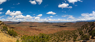
Nice red dirt and badlands along the Abiquiu River.
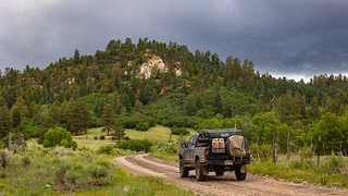
As we traversed Abiquiu Ridge, the sun finally broke through the clouds and things were looking fine; to our west. We were, of course, headed north.

The 'expert' trail was - clearly - rated by someone other than us.
Fifteen miles later, we were pulling into El Rito, our last expert section of trail completed. From here on out, there was only one track to follow as we trekked the final 100 miles to the border. It was 2:30pm and the clouds were looking fancy.
Fancy clouds.
The fancy clouds didn't last long. The strong winds from the night before had persisted all day - and were forecast to continue for several more - and as we headed out of El Rito, things were once again looking ominous. Maybe even a little more-so than previously.

The pavement is dry and there's a shadow, but I'll be darned if it doesn't look a little blustery up ahead.
I took this photo mostly because of the bright orange stripe that's peeking out through the trees. Turns out, the "let's ignore them now that we're on dirt" clouds add some nice drama.
We continued along for 30 more minutes with little-to-no rain hitting the Tacoma. It was surreal, actually - our trail seeming to thread the needle between storm cells, lightning flashing to our left and right. Even the ground was dry, as though some hidden force field was working in our favor.
Until it wasn't.

At least the truck was getting ... a nice wash?
With nothing to do but carry on, that's exactly what we did. And, except for the fact that we couldn't see very far into the distance, and that the "car wash" was in a constant battle with the "mud puddles," things proceeded as usual. Heck, I even braved the elements - and didn't melt when the huge rain drops hit me - to check out an old cabin we happened to come upon in the middle of the storm.

Run, run, run to the covered porch.

Pretty clean in there, actually, save for that missing piece of drywall.
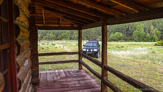
Run, run, run back to the truck. (And I'm soaked.)
After 40 minutes or so the rain stopped - or at least became intermittent - and the clouds in the sky began to break up a bit. We still had a good 30 miles to go before the end of the segment, and both of us realized that getting to Colorado in the dark - with nowhere to camp - might not be the ideal way to round out the BDR. Plus, we weren't in any huge rush to wrap things up, so we decided to start looking for a camp site even though it was still only 6:00pm.

I must say, the forests in New Mexico seemed well maintained - tree spacing and limbing was clearly a priority to help with fires, but there was no clear-cutting as there is in the Pacific Northwest. It was refreshing to see.
Not far from the logging - but far enough that we wouldn't be able to hear anything if they started work - we found a nice little knoll that we could call home for the evening. The ground was still pretty wet, and we had no idea what the rain situation would be in the coming hours, so the first order of business was to setup the tent and get dinner taken care of while there were patches of blue in the sky above our heads.

Though there was no view, this camp site - and the colorful knoll we were on - was rather idyllic and radiated "spring time."
A leisurely, no-cook, dinner ensued - pasta salad for me, and Spanish Tortilla for the lady - and we lazily prepped for bed, before I grabbed the laptop to transfer photos from the microSD card, and @mrs.turbodb grabbed her knitting to keep ourselves occupied for an hour in the tent.
It was 8:30pm - just after sunset - when we set our hobbies aside and broke out our reading materials. I think I lasted a sum total of 8 minutes before falling asleep, just as the rain started to pelt us from above.
The Following Morning...
We had a few showers through the night, but nothing that lasted for more than about 15 minutes, and perhaps 40 minutes of showers in all. By the time we woke up - just after sunrise now, even without an alarm - it was still cloudy but it was also pretty obvious that the rains were done... for a while.
All that was left was the 45 minutes it took to dry off the tent with a towel, before we could get under way.

Everything seems brighter after a rain.
From our camp site, we had perhaps three miles to go until we crossed US-64, and then we'd climb to elevations near 10,000 feet - near San Antonio Mountain - and duck in-and-out of high-mountain meadows, to round out the remainder of the trip into Colorado.

Not too muddy!

Good morning sleepy head, err, horse.
At one point during our ascent, there were a series of watering reservoirs for the local steak population. As we sped by the first one, I noticed the crazy green color but thought it must have been a reflection or that my mind was playing tricks. At the second, I hesitated to stop because I had some nice uphill momentum.

I couldn't pass by the third pool without stopping. Glad that's not my drinking water! At least the steaks are getting plenty of veggies, I suppose. 
Popping out to the high meadows was cool experience. I'm sure it'd have been even more dramatic with blue - or cloud-puff - skies, but it really felt like spring up here at 10K feet.
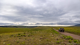
Meadows for miles.

I picked a few flowers for my sweetie, but wary of bug infestations that have entered the truck this way in the past, I showed them to her and then tossed them back on the ground.


The roads got a little muddier up here - it must have rained a bit more.
A few times, relatively large puddles covered the road. Like a good driver, I took these slowly, keenly aware that the internet might scold me for plowing through them. "Setting a bad example," and "tearing up the road when I should really be notifying the land owner so they can fix it." Finally though, I couldn't resist. At what would turn out to be the final puddle, @mrs.turbodb hopped out and snapped a few photos as I gingerly worked the speedometer up to 20mph.
Boy, what a rebel. 

Everyone needs to have a little fun now and then.

And seriously people, relax.

No roads were harmed in the taking of these photos.
From the high meadows, we dropped down only slightly into groves and groves of aspen. Their leaves fluttering in the wind and their bright white trunks rising toward the sky, we couldn't help but to comment on the fact that this place must be magical during the fall months. Even now, the green grass and red Indian Paintbrush made for a stunning display.
Prepping for fall.
The final few miles of trail threaded their way through a relatively narrow canyon before crossing the historic Cumbres and Toltec Scenic Rail Line just a stone throw away from the Colorado border. We savored these last couple of miles, even playing around - on what we thought were decommissioned lines - for a few minutes, before continuing on.

The final stretch along Rio de Los Pinos.

This was a mistake - this line is still in operation, so don't drive on the tracks. Interesting though to see the narrowness of the gauge, compared to standard gauge that we fit on perfectly in the Mojave Preserve.
Before we knew it, we were done. It was only just 9:30am and we'd reached the Colorado border and its always-friendly-and-strikingly-true welcoming sign. Of course, looking the opposite direction, there was nothing indicating the transition to New Mexico!
We made it! Welcome to Colorful Colorado. 
From here, the route winds its way down to a little town of Antonito, where fuel and food can be had before the inevitable trip home. For us, however, this would not be the end. We had grand plans for the next couple of days, and none of those plans included filling up with gas right away! 
The Whole Story


Love Backcountry Discovery Routes? Check out the
BDR Index
for all the routes I've run - they are fabulous!


")
")
")


")
Beautiful ride!
I loved the scenes with the poofy (cumulus) clouds, striking contrast. At least the mud was not the Owyhee gumbo. Thanks again for sharing your adventures.
Thanks Kenny! Glad to hear you enjoyed this one, even a little out of your backyard.
I sent you an email with a couple homestead photos with the gun port
You’re inspiring me to get off my asphalt in NM. Thanks
Absolutely Joe, glad you're enjoying the stories! You can always get more in your inbox by signing up here: https://adventuretaco.com/subscribe/
Great read, thanks for taking the time to share. Awesome pics
Hello,
we also enjoyed NMBDR.From the desert to the mountains.We did not imagine it like that, so now we do not guess anymore .
Few hours before antonito we got stuck in the mud . We were so happy to finish that i was not paying attention.
After 6 hours of digging we used our little red garmin and sent a sos.
The state troopers could not reach us but they found a rescue company. 18 hours latter we were free tired and poorer.
home , the first ting i bought was a winch!