
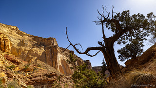
Initially making our way northwest along Temple Mountain Road before turning southwest through McKay Flat, I was glad we'd found a spot to camp so close to Temple Mountain the previous evening. In so doing, we'd avoided driving into the setting sun and now had the blazing ball of fire at our back, illuminating the road before us.

With the sky clearing and sun shining, the buttes of the San Rafael Swell were out in their full glory.

As we turned south toward McKay Flat, Family Butte rose colorfully to the west.

A group of three wild horses were curious, but kept a wary eye on me as I circled to the sunny side for a photo.
Where the roads most of the previous day had been slow going, McKay Flat was - for the most part - wide and smooth. Before we knew it, we were approaching the southern-most point of our loop, near Tomsich Butte, the huge monolith on the edge of Reds Canyon rising up before us as we approached.

A prominent landmark.

As we reached the edge of McKay Flat, the road continued on, descending into Reds Canyon between the plateau and the Wingate Cliffs to the west.

As we descended, a short spur led to an overlook that we both realized would have been a fabulous place to spend the previous evening.

There's no wondering why this is called Reds Canyon.
Following the road around Tomsich Butte, we got our first glimpse of the Hondu Arch. Located high in the Wingate Cliffs, this is the largest arch in the Swell, and one that I hope to hike to - starting from Mussentuchit Wash and approaching from the opposite direction - in the future!

The Hondu, towering above the landscape.
Within a few hundred feet, we reached the reason we'd come all this way - though in retrospect, it seems to pale in comparison to the surroundings - the largest of the Dirty Devil Mines, the Hannert Mine. Set back into a fold of Tomsich Butte, its long ore chute still towers above the wash, though access to it from the nearby shafts has been eroded away.

A monstrous ore chute that once carried radioactive material carved out of the mountain.

From the state of the ore bin, and the camp fire rings strewn around the site, this structure may not have much of a future. Not that I'd want to camp - and have a fire - at the base of a uranium mine!
Uranium was first discovered on the southern slopes of Tomsich Butte in 1951 by W. J. Hannert and John Tomsich. Several mines - known collectively as the Dirty Devil Mines - were opened by the two men, and for a few years they were successful. However, by 1956 most of the high grade ore had been extracted - to the point that Tomsich committed suicide as his initial success turned to bitter disappointment. Mining below Tomsich Butte briefly picked up again in the 1970s but quickly faded given the lack of high-grade ore.
Located in the Mossback Member - one particular part of the Chinle Formation - the uranium that fueled these mines started as random deposits of ancient organic matter that were deposited during the Triassic Period (200 million years ago). When the area was flooded by an inland sea, the organic material acted as a reducing agent, causing concentrations of mineralized uranium to precipitate out of the seawater.

Access to the main shaft - and all shafts in the area - has been sealed off. Nature has also eroded the road that once led to the opening.

Utah Abandoned Mine medallion.

In the tailings pile, some old det(onation) cord. I wonder where it leads. 

A look down the chute. Except for the whole radiation business, this would have been quite the view from the office.
Having arrived a couple hours before the sun would really be in the right spot for some well-lit photos of the mine, we explored the site for a while, hoping - a futile endeavor - that a few minutes might be enough for the sun to move a good 45° in the sky! Of course, that wouldn't have been ideal for the rest of our day's plan, and before long we continued on our way toward (what we thought was) the end of the road at Muddy Creek.

Along the way, we ran across this dugout. As I've previously mentioned, I don't know why, but I'm a sucker for dugouts.

At Muddy Creek, we had another spectacular view of Hondu Arch.
Planning to turn back at this point, we noticed that the road seemed to continue around Tomsich Butte - and given that a loop is always more enjoyable than an out-and-back, we continued forward. The road itself didn't end up being all that interesting along the north side of the butte, but it did spit us out at a junction where we planned to turn north for a run up through Reds Canyon on our way back to the center of the Swell.

Old mining sites the world over have one thing in common: abandoned vehicles. Anyone need an engine?

Perhaps an old pickup cab?
With the sun still behind us, we headed north, the iron-rich soil and sheer walls of the Wingate formation rising up to our west. It was a spectacular trail to say the least, and it seemed that as we rounded each bend in the road, I found myself wanting to stop for more photos.

This is what I was expecting from the San Rafael Swell.

Mineralized layers.

Wingate Formation panorama.
As we headed north, we made one - perhaps our only - navigational mistake of the trip. Reading about the area in a book that she'd downloaded for her Kindle - Hidden Treasures of Utah's San Rafael Swell - @mrs.turbodb assumed that a spur road I'd marked on the map wound up toward the Lucky Strike Mine. With an old cabin to coax us in, we soon found ourselves off the main route and walking around the base of an old ore bin - a sure sign that we were getting close to the Lucky Strike.

This old ore bin had seen better days, and like the Dirty Devil Mines to the south, its uranium mine shafts were sealed with a combination of rebar and concrete.
Continuing to follow the road, we eventually found ourselves at the head of the canyon, but the cabin we were looking for had evaded us. No worries, there were a few spur roads, and we assumed that it must be along one of those, a bit higher on the hillside. It wasn't until nearly an hour later - still empty handed - we finally decided to cut our losses and give up the search. 

Somehow the amazing views at the end of the canyon - which we'd gladly have come to see on their own - lost a bit of their flare as we struggled to find the cabin.
Stone and wood.
Not five minutes after exiting the canyon spur, we found ourselves passing another spur road. Leaning heavily into the brakes, we immediately realized our mistake as we looked at the GPS to see this one labelled as Lucky Strike Mine - we'd been in the wrong canyon! 

More Reds Canyon glory.

A cabin and two fridges at the Lucky Strike.

A second cabin and loading ramp used to fill trucks with uranium rich material that would be transported to processors.
In the end, we spent significantly less time at the Lucky Strike Mine than we had in our search for the same, just a mile or two south. Looking back now, I think I actually enjoyed the empty canyon - and it was definitely more visually appealing - than I did the one where we found what we were looking for.

Back on the Reds Canyon Road, now trying to make good time given the rest of what we had planned for the day.

As we passed Family Butte it was just after noon - about the time I'd hoped to finish up the loop and head back to the north side of I-70 as we continued our adventure through the Swell.
The remainder of the route - travelling the opposite direction on Temple Mountain Road than we'd done the previous afternoon - was a high-speed experience as we passed several of the RVs and toy-haulers making their way home from a weekend tearing up the roads and terrorizing the terrain in their UTVs. Before long we were headed east on I-70 for a few miles, descending much of the eastern flank of the Swell as we took an unmarked dirt road off the side of the highway and looped back under the pavement to enter Black Dragon Wash.

At the head of Black Dragon Wash, the San Rafael Reef was looking strikingly similar one of my favorite geological formations: Comb Ridge.
Having not yet eaten lunch, we decided that we'd push past a hike that I had planned in the area - to Spirit Arch and Petroglyph Canyon - and save them for after we visited the Black Dragon Pictograph Panel and filled our bellies. It was only a few miles to the parking area, and even stopping to enjoy a water-streaked sandstone bend in the wash we arrived within fifteen minutes.

Nature's rock art.

Did the striped walls draw in the Native American Indians in the same way it draws us in today? I'd like to think so.
Pulling up to the panel just a few minutes after 1:00pm, I grabbed the camera as @mrs.turbodb grabbed the plates - a familiar prioritization of activities for the two of us, and one that seems to work well, since I'm the slower one when it comes to gazing at the images plastered on they rocky canvas. Plus, I can't really complain one bit when I hear our whistle and know that lunch is ready for consumption!

The Black Dragon looks remarkably red to me.
Unique because of the unusual modernistic style, the Black Dragon looks so much like something out of a fantasy book that it is startling to realize it was painted centuries ago. Interestingly, this pictograph has - for the last couple decades - been the subject of a great deal of controversy. Creationists - who believe that the earth is less than 10,000 years old, interpret the image to be of a pterosaur, a winged reptile that went extinct some 66 million years ago. This, they say is proof that humans inhabited the earth at the same time as dinosaurs - in a much more recent time. Scientists, however, believe that the Black Dragon is an example of Barrier Canyon style of rock art, likely painted by the Archaic Peoples that lived in Utah some 2000 to 4000 years ago.
The roots of this controversy can be traced back to the late 1940s, when a man named John Simonson traced what he thought were the edges of the faint pictograph in chalk, thus revealing what appeared to be a winged monster. Recently, however, the painting has been studied using x-ray fluorescence technology, and it now appears that the winged monster is actually a compilation of five separate, more mundane images. Unfortunately, the technology still does not allow us to determine how old the painting is.Hidden Treasures of Utah's San Rafael Swell

A man and his (howling) dog.

Howling at a sunstar.

A second nearby panel with more traditional Barrier Canyon Style figures.
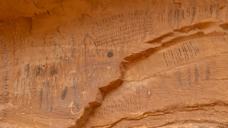
Besides the BCS panels around the Black Dragon, there is a very long Fremont Style panel nearby. Its use seems to have been primarily for counting various things as there are thousands of marks, high up the canyon wall, which would have required a ladder for access.

Fremont ledger.

Feather and lollipop detail.

Arch detail.
Necklace and hand detail.
Not realizing that there was another - albeit more modern - panel a little further up Black Dragon Wash, we returned to the truck after enjoying these older panels and soon we were on our way back towards I-70 and the trailheads to Spirit Arch and Petroglyph Canyon. As we arrived, we noted a van that we'd seen earlier in the day as we'd arrived at the Black Dragon panel. Apparently, someone else had the same good idea we did!
It was nice to set off on foot after what had largely been a day of driving so far. And, as we worked our way along the trail, we soon rounded a corner with another great view of the San Rafael Reef.

San Rafael Reef anticline. The cool thing is that - since the entire San Rafael Swell is a bulge in the earth's surface, both sides of the formation angle up toward the center.

Spring runoff.
After about a mile, we reached the shared mouth of the two canyons we were after. With no real preference for which to investigate first, we simply chose the one on the right - to Spirit Arch - because we happened to be approaching from the right. You could say that we made the right decision. 

I always love the anticipation that comes with entering a canyon like this. Somehow, the colors on the walls and the form of the sandstone are always so fascinating.

To our surprise, we didn't see many spring flowers on this trip - but this cactus, getting an early start on his buddies, was definitely showing off!

After winding our way up the canyon, we found eventually found Spirit Arch. Note the second arch just below the first.

My favorite part of the hike to Spirit Arch was actually the water staining along the walls of the canyon.
I think Spirit Arch was a little underwhelming for both of us, so we didn't spend long gazing up at it before we beelined it back to the convergence of canyons and headed up Petroglyph Canyon, hoping for something a bit more interesting. Almost immediately we were rewarded with a little bit more spring color - this time in the form of new growth on a Cottonwood tree.

Brilliant!
A bit more walking and soon I spotted the panel for which the canyon was named. Not large, it was in great shape - the figures pecked into the darkly patinaed surface, as bright as could be.

I wasn't sure whether I should call this panel "Footprints" or "Echo."

The left side of the panel with a sheep, man, and dog. I've never seen a panel before where the figures were trailed by footprints.

The right side of the panel, an echo of the left.
We didn't find any more noteworthy art in Petroglyph Canyon, but we did explore our way a little deeper into the reef to a - too narrow to navigate - slot canyon, and we also admired another display of water stains on sandstone where a spillway must have existed above.
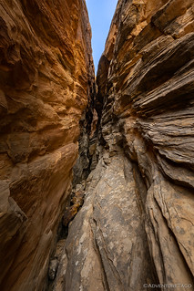
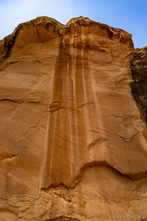
Narrow passages and wide waterways.
Eventually of course, it was time to go. We'd enjoyed this short stroll into the eastern edge of the Reef, and as with every other place we'd visited so far, I'm sure we only scratched the surface. With countless canyons and washes, this is a place we could wander the weeks away, poking our heads around corners and climbing our way up slickrock surfaces.

Headed back down the trail to the well-concealed Tacoma.
For now though, we knew that there was plenty more to see before the day came to an end. And it was then - at the end of the day - that I hoped we'd find ourselves at the most dramatic camp site of the entire adventure. High over the Swell, looking down from the Wedge over Utah's Little Grand Canyon.


For anyone interested, here is some additional information - from a BLM informational sign - about the Tomsich Butte Uranium Mines:
For anyone interested, here is some additional information - from a BLM informational sign - about the Lucky Strike Uranium Mine:
More wonderful photos and lore, next best thing to being there for those of us who can't make the trip, thanks so much! BTW -"In the tailings pile, some old det(onation) cord. I wonder where it leads," and with those words I'd say a true adventurer would fire up that det-cord and see what happens! LOL! Although it might be the end of the world as we know it, LOL ?
Hahahaha! Maybe not the end of the world as we know it, but perhaps the end of the "true" adventurer, and I couldn't do that to you - after all, I need to get out on the next adventure for you (but really both of us) to enjoy!
Thanks as always for the kind words, I really appreciate them. They put a smile on my face every time.
(and sorry for the slow reply, I just found a bunch of comments that were incorrectly marked as spam, so I'll need to dig into the guts of the site to figure out what's going on)
Enjoyed your writings about the Temple Mtn side of SR Swell.
It’s after the fact now because you have probably already written your next segment on the “Wedge”. Unfortunately, the best part of the wedge is now closed to camping as you must have found out when you passed the outhouse and started to turn left. For many years we would camp at the very end of this road where there is a metal picnic table and an incredible view of the “Little Grand” with the San Rafael River flowing through it Alas!
The multitudes have taken over. We were there two weeks ago and there were 25 atv’s parked at the spot where we used to camp.
Going to be spending more time on the south side of 70 from now on.
Hey Greg, (sorry for the slow reply, I just found a bunch of comments that were incorrectly marked as spam, so I'll need to dig into the guts of the site to figure out what's going on)
We did find out that the "best part" of the Wedge is now closed to camping - bummer, but understandable I suppose. We still got a pretty nice spot (as you may have seen) on the other side, away from the overlook.
The south side of I-70 - as long as you don't end up over at Temple Mountain (which was PACKED with UTVs) seems like a pretty cool place. I've already got another 2-3 trips worth of stuff lined up for down there... as soon as the weather cools a bit! ?
Great commentary and pictures, as usual!!
I vote for "Footsteps".... In case you are asking!!
David
P.S. that area ... looks like even I can do in my truck!
Thanks David! I like "footsteps" too! And you can definitely do this in your truck - in fact, this entire trip with the exception of Devil's Racetrack, would probably be doable.
(and sorry for the slow reply, I just found a bunch of comments that were incorrectly marked as spam, so I'll need to dig into the guts of the site to figure out what's going on)
Wow, I just relived the story of my Dad discovering uranium in 1949, and of all things I was with him. The pictures and facts are perfect regarding the Dirty Devil and Tomsich Butt. It was very sad that he committed suicide over it, I was in my teens.
Thanks for a great story.
Wow Josephine, I hope that the experience of reliving that wasn't too painful - I can't imagine what that must have been like, to experience such a loss. At the same time, I hope I did justice to how beautiful I (and you) thought the area was, and how amazing a site exists(ed) there at Tomisch Butte.
I'd love to hear any stories - no matter how short or long - you have of your time there. Little things that stood out about the operation, daily activities you remember, anything that you look back on, if you're willing to share!
I just wanted to let you know that our last name is pronounced with a SICH, not SICK, my Dad was Austrian. The DOG in the story was not my Dad's, he disliked dogs very much and so it must have belonged to my brother, John.
Men from the boarding house worked in the mines and on building of the roads.