
It was four years ago when we ran our first Backcountry Discovery Route (BDR) - or at least, we attempted to run a stage of the Oregon BDR and failed miserably. Later that same year, we successfully conquered the route, and since then we've tackled one BDR every summer - Washington, Idaho, and Nevada now under our belts. This year, we decided that New Mexico would be a good state to tackle on what has become a fun tradition.

Starting in Dell City, Texas - finishing some 1,200 miles later in southeastern Colorado - the NMBDR is unlike any route we've driven in that it begins more than 24 hours - of highway driving - from home. We were going to need a full two days of driving just to get there!
Day 1, 2, and 3
For that reason, we decided that we should take advantage of some of the places we'd otherwise just "pass by," on our way to - and from - our primary route. And so, on a Sunday morning we headed south under sunny skies, our goal to make it just south of Salt Lake City by the time we stopped for the evening.
Soon enough we were in Oregon. Splendid weather continued, and we listened to podcasts as we were passed by all manner of vehicles that are speedier than Toyota Tacomas.

If this driver only knew... 88mph - not 75mph - is the optimal speed for a DeLorean.
Ten hours or so into our trek - a little more than halfway for the day, we crossed into Idaho. And a few hours later, Utah.

So central. A good place to live if you're an explorer. Though, I hear it's full.

Utah really does have the best border signage. Unfortunately, also a full state, apparently.
It was just after midnight when we pulled into our creek-side camp site - one that we frequent on long trips south - and just after 6:00am when we packed up the tent and pointed ourselves toward New Mexico. It was already hot - the middle of one of the hottest heat waves to hit the southwest and west coast in the last decade; the haze hanging heavy across the landscape.

We could barely see the Book Cliffs north of Green River, UT.

The haze did make for a peel-back-the-onion view of the layers of cliffs.
We pulled up to our first pit stop at the south end of Cedar Mesa just before 11:00am. It wasn't a month earlier that we'd hiked much of this area as part of our Forty-One Miles of Mesa trip, and I'd visited the main rock art panel at this very location just a month prior to that (Utah, Re-Ruined). But this time we were at the Sand Island Petroglyphs for another reason - the Upper Petroglyphs.
It is not only a disgrace but a federal crime to destroy of deface rock art. Please respect these images from our collective past. It is our responsibility to preserve these enchanting messages. No one comes to these places to see your name.BLM sign
We found a spot to park in the shade, and nearly had the wind knocked out of us by the heat as we exited the truck. It was already in the mid-90s °F and would only get hotter. We grabbed our water and set out along the trail towards the panels.

These glyphs are nearly invisible again, the years and patina taking their toll.

Some of the panels were more than 40' off the ground!

Quite the array of anthropomorphs. A band of dancers, and earrings on several of them!

Bird in the belly.
The highlight - by far, at least for me - was a panel that's reasonably well hidden from the trail, and we only happened to catch a glimpse of as we were walking along. Ultimately, I maneuvered for a better angle and found myself face-to-face - literally - with some of the most interesting glyphs I've ever seen.

Faces, bright against the sandstone.

Hunchback.
We continued along, hurrying due to the heat and yet not wanting to miss a thing - these rock art images depicting over 3,000 years of history by people who lived, farmed, and travelled through this land. Archaic (3000 BCE - 400 CE), Puebloan (1000 BCE - 550 CE), Navajo (1500 CE), and Ute (1500 CE) people left their imprints etched in stone, preserving their memories through centuries of time.
Eventually though, we were ready to turn back and find respite in our air conditioned cab as we headed into Bluff for lunch at the Twin Rocks Cafe where we ordered our first ever Navajo Tacos. It was our first time eating at an establishment in 15 months, and to ease ourselves back into the experience, we opted to eat outside.

The fried bread was fantastic. I think we could have done a better job with the toppings we ordered however.
An unfortunate story unfolded in front of us while we were partaking in the local food. The restaurant - run by locals, but of course getting most of their business from tourists - still had a "masks required until seated" policy for those eating inside the establishment. This caught nearly everyone who came to the door by surprise, but most of them understood and respectfully returned to their cars to grab a face covering. However, one older woman stood outside the door and complained loudly that, "We should've bombed China a long time ago!" Interesting that she felt that way, given the country of origin of the purse she was digging in for her (internationally sourced) mask and the (made in China) sneakers she was wearing.
Seriously though - the world would be a much better place if we all showed just a little more respect for one another, no matter what our beliefs. If we looked for common ground rather than conflict. Hope and happiness over hate. I wonder if a visit to Manzanar would benefit Americans who have forgotten how good we have it, and what we can become.
Off my soapbox, we finished up lunch and headed about half a mile out of town to one final petroglyph panel that I'd not gotten around to seeing the last time I was in the area. Only a few feet from pavement, we arrived at the Atlatls Panel with the sun in a terrible spot for good photos, but I climbed up anyway to get a better look.

Most everyone just drives on by.

The atlatls held by these two figures were spear-like hunting implements.
And with that, we pointed ourselves toward New Mexico, crossing the border a little more than one hour later - to perhaps the most appropriate border crossing sign I've ever seen.

We never saw any "Welcome to New Mexico" signs until the very last day of our trip. Seemed appropriate though.
Still pounding the pavement, we continued south and east - doing our best to carve a path through the state that wouldn't overlap too much with the BDR that we'd be running over the coming week.

New Mexico's colors were looking promising!
Ultimately, we found ourselves tiptoeing over the border into Texas as we pulled into the Dog Canyon Campground - part of Guadalupe Mountains National Park - a little after midnight. We climbed into the tent exhausted, the temps still in the low 90s. This was definitely going to be interesting.
As morning dawned, we were up with the sun - a full day ahead of us. I'd planned to get a couple additional stops in before lunch, and then kick off the first stage of the NMBDR by noon at the very latest. 

Fantastic fog rolling over the Guadalupe range.
Eager to get going, we skipped breakfast for the time being and pointed the Tacoma towards Sitting Bull Falls. Located not far off the first leg of the BDR, I'd wanted to make the detour as part of that leg, but was convinced that the more efficient route would be to visit the falls - and our second stop of the day, Carlsbad Caverns - prior to actually starting the official trail.
As we wound our way back along NM-137 - having seen essentially nothing in the dark the night before - we reveled in the morning sun, the yucca and agave reaching for the sky.

Even at our leisurely pace, it was only 8:15am or so when we arrived at the gates to Sitting Bull Falls - a few minutes before the gates opened. We ate breakfast in the shade as we waited for the NPS ranger to grant us access, our day use fee covered by our America the Beautiful Pass!

A quick hike from the parking lot - a quarter mile or so - and we reached the falls. #WorthIt.
Archaeological evidence indicates that this canyon has been occupied for the past 10,000 years beginning in the Paleo-Indian period. The first written account came in the 1860's when soldiers encountered a group of Apache Indians camped near Last Chance Canyon. Soon after the tum of the century, the water was being used to grow fruit trees and raise livestock on a small homestead at this desert oasis.NPS Information Sign
I nearly had to drag @mrs.turbodb away from the falls - this was, I think, one of her favorite parts of our entire journey. But drag I did, and soon we were underway again - though still towards another "distraction," rather than the BDR.
In fact, we never even made it that far. As we sped along a gravel road, I noticed a lizard scurry out of the way. This, however, wasn't just any lizard - the body shape wasn't right - and I may have stopped a bit too abruptly for my passenger. Again however, it was worth it.

Doesn't look like he's a morning guy. Little grumpy generally, perhaps.
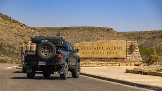
Finally, 90 minutes after leaving Sitting Bull Falls, we reached Carlsbad Caverns. I'd always heard that these were cool, but I really had no idea what to expect. Actually, I was a bit worried, since I'd only been able to secure one (the last) reservation to see the caves and it was going to be a bummer if only one of us could go in.
Screwing up the BDR schedule again. Oh well, adventure! 
After waiting in line for a few minutes - it turns out that the reservation simply allows the reservation holder to reserve a ticket into the caves - we approached the NPS agent and I explained our situation and asked if there was any way for us to both go in. To our delight, not only were we both able to go in - again, for "free" with our America the Beautiful pass - but we were able to get in an hour ahead of our scheduled time! Maybe we could get back onto our BDR schedule after all. (Spoiler: nope.)

Down, down, down. The entire path through the cavern was rubberized asphalt - a pleasure to walk on.

Goodbye daylight.
Soon, we were in another world. A fantastic world. For nearly two-and-a-half miles we wound our way through stalagmites and stalactites - wondering if the path and lighting built nearly a century ago by the CCC would even be contemplated today, or if preservation of such a cave would win out. Surely, anyone able to visit this cave is lucky to have it in our folio of National Parks.

A brilliant hall.

Whale's mouth.

Cascading fountain.

Cave bacon. (Actually called curtains.)

Mirror Lake (note the reflected sign).

A chandelier of stalactites.

Sleepy dog (foreground).
In the end, I think Carlsbad Caverns were one of the highlights of the entire trip for me. If you ever find yourself in the area, this is a must see place. Take your time as you walk through the caves, enjoy yourself. It's totally worth it. Oh, and don't forget your tripod. My shortest exposure was about 8 seconds!
Making our way back to ground level, we'd found that we'd spent nearly three hours exploring in the cool, damp caves - a great way to escape the 107°F temps outside! Now it was early afternoon and time for a quick lunch - in the shade - before our final push south towards the start of our route.

Texas is giving Utah a run for their money as far as border signs go.
It was 4:30pm when we finally rolled into Dell City, TX - definitely not an early start to the first leg of the New Mexico BDR!
The Whole Story


Love Backcountry Discovery Routes? Check out the
BDR Index
for all the routes I've run - they are fabulous!


")
")
")


")
Amazing as always!
Thanks Verlan, glad you're enjoying them! ?
Texas Horned Lizard, commonly called a horny toad by us Texans, and the mascot of Texas Christian University-TCU. BTW, love your Taco blogs! Keep up the good work!
Hey Coach, thanks for the identification! Man, that's a cool little lizard! And, happy to hear you're enjoying the stories; more to come of course!
Thanks once again for a lovely trip. Hot enough here in so cal that I felt yr pain thru whole trip. Thanks for Carlsbad info and pics. Now i am dying to go there. I thought it was all about the bats. lol great shots good narative as always. thx yall.