
I have organized this story a bit differently than most.
Some of the locations have little or no reporting on the internet and I feel they should remain that way or someone I respect has personally requested that I not share them; as such, locations have been redacted and/or not mentioned, I've used non-official names for local landmarks, and the order of the trip has been randomized.
Please, if you know the locations shown here, I encourage you to enjoy them as much as I did - and follow my lead by not mentioning their names or locations in order to keep them a little less well-known, and special.
For more on my approach, you can read Do you have a GPX for that?.
The last couple years have been tough on the forests of California. According to data from the California Department of Forestry and Fire Protection, 2020 saw more burned acreage - 4.4 million acres - than any recorded year in history. More than 2.5 million additional acres have already burned as of September 30, 2021.
Two of these fires - the 2020 █████ Fire, and the 2021 Dixie Fire - had the largest impact on me, the █████ Fire burning through my Dad's favorite camp site, and the Dixie Fire nearly destroying the homes of two of my Uncles (and their families).
These fires are, of course, due to several compounding factors. An unprecedented lack of water has left more than 97% of the state in drought, with more than 20% of the entire western region in severe drought - significantly higher than any other time in the last 20 years.

Drought data for the U.S. West from 2000-2021, NDMC, NOAA.
Additionally, forests have become increasingly dense. For years, forest management practices focused on extinguishing fires in order to protect living trees. Over that time, the encroachment of structures into the forests meant that - even as management policies adapted to acknowledge the benefit of fires to a healthy forest - we often continued to fight fires in order to save those poorly located structures.
As if an almost total lack of water wasn't enough stress on the trees, overly dense forests have meant less water for each tree, weakening them further and making them even more susceptible to beetles. Bark beetles, are native to the United States, reproducing in the inner bark of trees, spreading a fungus that eventually kills the entire tree. Massive outbreaks of beetles since the mid-2000s have resulted in the death of millions of acres of forests.

In an unburned forest, brown-needled pines are a sure sign of beetles.
Of course, the combination of record drought, closely packed trees, and more dead wood that we've ever had in history, means that the fires that do break out are larger and more intense.
It was with a sinking feeling that my family watched the █████ Fire burn through a favorite camp site - one my dad has visited hundreds of times over the last 40+ years - as it consumed 379,895 acres between September 4 and December 24, 2020. The surrounding area has been closed ever since due to cleanup efforts and unsafe conditions.
Even after that experience, none of us expected that the 2021 would hit even closer to home. The Dixie Fire - started on July 13, now 94% contained as I write this at the end of September - began heading in the direction of family members homes. On August 21, fire encircled the property. Ultimately their residence survived - thanks to extensive preparation they'd performed over the years, the hard work of dozens of fire fighters with heavy equipment, and a lot of luck - but not before the fire burned through over 963,276 acres. Several hundred homes - and entire towns - have been lost.
And so, when my Dad and I learned that the National Forests of northern California were finally opening up on September 14, 2021, we immediately made plans to pack up our chainsaws and do our best to reach his camp site. Regardless of our success, we wanted to see the situation with our own eyes. And, at the same time, I also decided to make my way home through the heart of the forest burned by the Dixie Fire.
Day 1
I pulled out of the garage just before 10:00pm, opting to start the 19-hour drive in the dark and cover as much ground as I could through the night. Not only would this result in less traffic, but since Pops was only going to be able to camp for one night, it would allow me to arrive with enough time to hang out a little bit. Or - perhaps more likely - spend a few hours of quality labor, working with him to clear the road to camp!
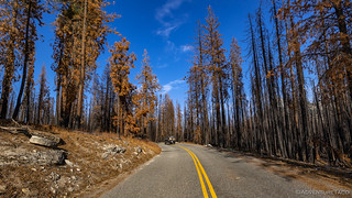
It was 3:40pm when I initially headed up into the ██████ National Forest along ████████ Road.

Anticipation and trepidation.

A few weeks earlier, the KNP Complex had started up in Sequoia National Forest, and it was quite smoky as I looked out over the valley.
It was along ████████ Road that I got my first look at the destruction. Entire hillsides that had once been covered in trees and vegetation were but blackened skeletons of their old selves. Stumps - of once-grand oaks and pines - reduced to charcoal as the fire burned through.

Not a good sign, but likely representative of what was to come.
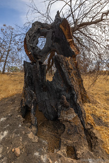

Charred remains.
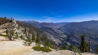
As I climbed in elevation, the oak giving way to pine, my views of the valley faded and views into the mountains opened up before me. Shocking views, really - so different than they'd been the last time I'd come this way.

My view of ████████████ the last time I'd been through.

My view, from the same spot, today.
The local scenery was no less dramatic - some trees entirely devoid of needles; others clearly dead but still maintaining their previous form, for now.
Yesterday's soldiers.
Eventually I found the turn I was looking for - now devoid of any signage - singed post bases now the only indication that something of interest may have existed this way. To my delight, however, there was no sign of Pops, and I could see his tire tracks leading down the trail.
At least he'd had a chance to clear a little bit before I'd arrived!

Now on dirt, the view eerily similar to what I'd seen so far.

Truck-sized trees, no match for the inferno.
As I progressed further and further along the trail, it was clear that the good folks from the USFS (and anyone else assisting in the cleanup) had been hard at work. Trees - some with diameters of 6 feet or more had been cut and cleared off the road, and the road itself was in significantly better condition than I've seen it in the past.
And then, a quarter mile from camp, I ran across Pops, out scouting the botanical and aviary situation in this new landscape. We said quick hellos, and he headed cross-country as I traversed the last few thousand feet to camp and pulled my truck in what has become "reserved parking," whenever I am around.

Evening light on ████████████, rising up in the distance.

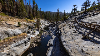
My spot. Still breathtaking.
By and large, the immediate area around camp had been spared the total destruction that I'd seen on the way in. The site - which is nestled into the edge of the treeline as it transitions to granite outcroppings - was in relatively great shape. The fire ring was still there, several of the trees along the treeline were only partially scorched, and nearly all of the trees that dotted the granite slopes were completely unscathed!
As I marveled at how lucky we were, Pops wandered into camp and we shared our wonder at how much better the situation was compared to what we'd pictured in our heads. The sense of relief was, I think, a huge weight off his shoulders, and something we'd been wondering about for nearly a year.
We spent the rest of the evening in our camp chairs, around the fire ring. Naturally, there was no warmth from the rocky structure - fire bans were still in full effect, and sitting in the middle of a burnt forest, having a fire just didn't seem appropriate anyway. Still, the conversation was lively as we discussed all matter of topics as the sun set and the moon began its journey across the sky.

I wondered if I could get a photo similar to the one I'd recently gotten on a trip to Rady Creek.
Having been awake for 24 hours straight, I bid Pops good night around 10:00pm and quickly fell asleep to a light breeze and the anticipation of what tomorrow would bring as we investigated the area around camp.

I pulled myself out of bed at 4:00am for a quick photo of the brightest stars, a full moon and smoky skies obscuring the rest.
Day 2
It was 8:00am when I climbed out of bed. I was sure that Dad had been up for an hour or more - birding - and was surprised to catch him walking down the trail from his bed-down location as I was capturing the morning sun on ████████████. As quietly as I could, I shuffled myself behind a few trees and began stalking him - like the ninja I am not. 

Looking quite smoky this morning.

Binos come in handy not just for birding, but also to see if your kids are still in their tents!

Having discovered the tent was empty, even Pops couldn't resist a truck shot.
Remaining out of sight, I skirted a few larger rocks to continue my stealthy stalking. Of course, I was lucky that Dad didn't have his hearing aids in - it's nearly impossible to be quiet when walking on disintegrating granite, the crunch of even the softest footstep, enough to alert those around to my presence.
A burned mosaic on the slopes of Sleeping Bear.

Birds on the brain.

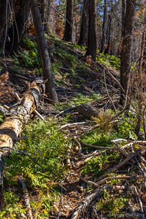
Still so much green right around camp!

The smoke was a constant reminder that danger remains just a lightning strike away.
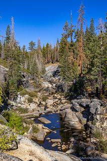
My no-ninja skills only lasted about 10 minutes - a random glance in my direction, and I was spotted. I headed over to say good morning, and we decided that there was no better time to take a walkaround than the present. Our route would take us down to the creek - and to a swimming hole that offers a cool respite on hot, dusty, summer afternoons.
This year however, things were... a little different. First of all - and not totally uncommon for this time of year - the water level was quite low. More troubling - though I suppose not surprising as I think about it more - was the color of the water. It wasn't the clear, seemingly clean, water that we were used to - nope, it was an orange murky mess, the result of all the charred debris that'd washed down through the winter and spring.
Not much water down there.

The swimming hole has definitely seen better days. Not too appealing this year. And shallow!

Usually, there's very little silt, and the rocks aren't covered in orange algae.

The culprit. All around the banks, charcoal nestled into the river rock. Washed into the creek after the fire, and carried down in the high waters of winter, it will take years for this creek to recover.
After winding our way down and around the swimming hole, we started making our way back to camp. Eager to explore a bit more, I left Pops to his birding and I went back to grab some water, a granola bar, and a bit more camera gear for a hike to a nearby ridge.
Little did I know - because we couldn't really tell from camp - but my experience hiking up to Lost Knife Knoll was going to be an eye-opening one to say the least!
The Hike
As I set out across the ███████ Bridge, things still looked relatively normal. Sure, there were some dead trees, and many of the trunks were black with soot, but in general, the granitic ground in the area around the bridge meant that many of the trees had survived. Coupled with the condition in which we found camp, I figured the rest of the hike would be similar.

███████ Bridge, unscathed by the fire.
You can see here again, how dark the bottom of the creek bed is due to all the charcoal in the water.
When I got to the other side of the bridge, my first surprise was only a few steps away. This is a reasonably popular trail, but having been closed for nearly a year, and with the USFS attention turned to more immediate and pressing routes to get open, it was in complete disrepair. Grasses and shrubs grew up in the path, and of course downed, charred, trees were everywhere!
Usually a well-beaten path, nature has reclaimed the trail quickly.

Soon, I was entering the ███████████ Wilderness.
As I transitioned from granitic surfaces to more forested ground, so too did the experience above ground change. More and more trees - perhaps even the majority of them - were burned. Some, to a crisp. I was, quite literally, walking through a graveyard.

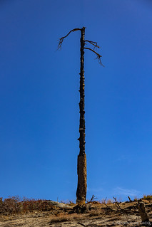
A once tall and majestic pine, now scarred and barren.

As I walked through the brown, I quickly realized how lucky we really were that the camp site - and area around it - was still relatively green.
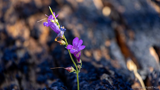
Even in all the destruction, life was poking through - in this case, growing out of a downed tree.
To reach Lost Knife Knoll requires a cross-country trek up a several-hundred-vertical-feet hillside after a relatively leisurely stroll along the access trail from the bridge. And, ever since the first time Dad and one of his buddies took me to this place of theirs - I've used an ancient juniper that they pointed out on the side of the trail to indicate where to veer off. In fact, it had become one of my favorite landmarks - one I always look forward to when I visit.

Dad standing at the juniper in 2018 on our Somewhere in the Sierras trip.
Unfortunately - though perhaps not surprisingly - the juniper waypoint is no more. Clearly caught in the heat of the fire, it burned thoroughly enough to collapse, and likely continued to burn even once it'd fallen.

A sad sight, as nature reclaims this beautiful tree.
After a short pause, I continued up the slope. Here, the impact of the fire was significant - much more so than it'd appeared from camp. Almost all of the underbrush had been burned, and the trees were in tough shape to put it nicely.
Fire got into the canopy, but the lowest 10 feet were nearly unscathed.

The view behind me as I climbed toward the ridge.

A well-known rock - previously covered by manzanita but still the easiest route up - is now much easier to climb, and only one of several paths on the way to the ridge.
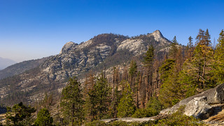
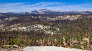
Things changed again as I reached the ridge and Lost Knife Knoll. While the hillside I'd hike had been decimated by fire, the fire line seemed to peter out before making it too far down the other side and into the ███████████ watershed. Of course, smoke from the nearby KNP Complex was visible here too as well, but the views were generally familiar to previous years.
The ridgeline acted as a natural fire break.

A favorite tree under which many-a-lunch has been eaten.

It continued to get smokier throughout the day.

Of course, I made sure that the lost knife was safe under its stone shelter.
Besides the fantastic views, one other feature of Lost Knife Knoll is that it's high enough to provide cellular reception - something unavailable in camp. As such, I took a few minutes to check my email, text @mrs.turbodb, and firm up my plans for my return trip through some of the forest burned by the Dixie Fire. And then, it was back down the hill to camp so I could relate my findings to Pops.
My view as I started back down the hillside - a mosaic of burned trees.

As long as I've been coming to Lost Knife Knoll, there's been a cool decaying tree trunk, its bright orange contrasting with the surrounding green.

No longer.
The trip back to camp was significantly quicker than the trip out, since there were many fewer photo stops along the way, and soon I was enjoying the splendid view from my reserved spot as I dropped the camera and my pack into the cab of the Tacoma. I decided that I ought to pack everything up and then head into the camp site proper where I could make lunch and lounge around a bit in the shade before Dad had to head home - at which point I planned to investigate the condition of the road to ██████ Mountain.

Wows me every time.
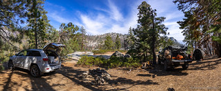
Two trucks in camp for lunch.

Two bozos in camp for lunch.
It was somewhere around 4:00pm when everything finally got packed away and we headed back up the trail. Dad was nice enough to let me lead the way, "So you can take care of any trees that fell over the road while we were here." 

Heading out.

Our final view of ████████████.
We'd been in camp for only 24 hours, but I think we were both relieved and excited to know that the site will - hopefully - be both visit-able and enjoyable for years to come.
The Whole Story


Hey Dan, thanks for the trip report. As a recent immigrant to California, I began educating myself about the topic of wildfires. One aspect that I find remarkable but that is rarely mentioned in debates about the issue is that prehistoric levels of wildfires before firefighting interventions of western civilizations were likely multiple times higher than what we experience today in a "bad" fire year.
Estimates prehistoric fire areas [1] are between 4,484,009 and 11,955,682 acres annually. Smoke-filled skies have been a part of California even before humans settled here. As you said, proper forest management (including prescribed burns) seems to be the way forward. There are a multitude of reasons for fighting climate change, but blaming the pure magnitude of fire seasons on it is a little disingenuous I think.
[1] https://www.sierraforestlegacy.org/Resources/Conservation/FireForestEcology/FireScienceResearch/FireHistory/FireHistory-Stephens07.pdf
Hey Jupp, Glad you enjoyed the trip report, and thanks for weighing in. I haven't read through the PDF you linked yet, but it's certainly interesting to take into account when considering fire sizes today, so I'm going to spend some time reading through it this evening. I agree with you that prehistoric burns are rarely (I've never heard anything at all) mentioned. As for blaming the pure magnitude of fire seasons on climate change, and that being disingenuous - I don't believe I blamed the magnitude on climate change. In fact, I never used the term in the story at all. Rather, I said that drought was a contributing factor to size - which it surely is, as are beetles (dead wood) and our building of dwellings (that we feel must be protected).
Regardless of prehistoric fire sizes, those things are surely contributors today. And, while I don't know that we should get into a whole discussion about the reality (or not) of climate change (full disclosure, I think it is a real thing), my main point for this story is that the last couple years have been tough ones on areas of the California forests that were special to me. I was simply trying to give some context that could have contributed to those tough years.
Hope that makes sense!
I visited this place in July so I could finally find the lost knife and the tip of the spear you had mentioned in your previous trip reports. A family with young kids had already claimed "your Dad's site" when I got there. I saw them enjoying the swimming hole on my way up the ridge. The water level at the time was a bit higher compared to your pictures, but seemed lower compared to my previous visits... I also noticed the color of the creek and some algae build up that made it less appealing than before. The conditions in the area as I made my way up the ridge looked practically the same as the photos you posted. Looking at your pictures literally brings me back to that day. Still shocked and saddened at the amount of destruction cause by the fires...
Hi Joe, Thanks for sharing your experience. I'm surprised you were able to get to the site in July - it was my understanding that the area was closed at that point, but I certainly could have misunderstood. It will be a while before the area recovers, obviously, but it's all part of the cycle I suppose. Thanks for keeping references vague and the place "a little less known," I appreciate it. 👍
Being a tree-hugger, it was hard to see that beautiful tree laying in a burned heap on the ground where you had previously taken a great photo of your Pop. Brought tears to my eyes. Thanks for the update on how bad/ and not-so-bad it has been thus far. Our beautiful, impressive, georgeous, west coast is losing so much and it's heart-breaking hearing the news of it daily. Hang in there Turbo.......keep on keeping on.....I need to see all I can while I can.....living thru your great adventures here at home masking up and trying to stay safe , but enjoying the days thru your trips doing what I love most. thx
It's hard for me to understand why the US government can't spare funds to start planting lightning-catching poles, grounding them to the earth.
It won't prevent wildfires completely but can reduce them by a lot.
Covering all forests is probably impossible but with some weather statistics, the government can target areas with great risk for lightning fire.
Thanks for the comment Yaniv, I hope you enjoyed the story, even in its "painfulness."
Your comment got me thinking - as I'd never heard of installing lightning rods in the forest to prevent fires. After some reflection, I'm not sure that fighting nature is the right path forward. Already, the forests are not healthy in many situations (as I've touched on at the beginning of the story) due to excessive amounts of dead wood - both standing and fallen. For all their destruction, fires also do a lot of good to forests - in addition to cleaning out much of the dead wood and fertilizing the soil, certain flora even rely on fires for propagation - and have been around just as long as the forests have been.
Perhaps there is some way of both preventing fires and maintaining healthy natural environments, but simply preventing fires isn't - in my opinion - the way to do it. And, the forest stewardship is probably orders of magnitude more expensive than the lightning poles.
I'm sure that there are ways that US government money could be better spent than it is today, but - again in my opinion - this isn't it. There are a lot of people - both in the US and the world at large - that need help in one way or another. That are starving or homeless or living in conditions that those of us talking about the aftermath of forest fires likely don't have to deal with. They might be better recipients of the funds in many cases.
Anyway, just my thoughts for now. I hope you continue to enjoy and I always appreciate the comments!
I often think about the recreational value of these areas and how they influence people. I live in Colorado and the Cameron Peak fire destroyed a large area that my family had enjoyed for four generations. I'm saddened by the fact that my grandchildren will not have the same enjoyment of these areas for many years to come.
I agree that better forest management and the clearing of dead and diseased trees is key to helping preserve our forests. My grandfather was a career forest ranger and worked in the 1940s in Colorado to mitigate the beatle kill damage to our forests. We need to work to fund the protection of our forests.
Thats such a bummer! I found your camp earlier this summer on google it def took me some time. I still look forward to heading up there but what a bummer to see it all burnt. The dixie fire is my back yard and pains me to see it the way it is now.
Hey Dan, your dad alerted me to this posting when he recently sent me his journal from the same trip. I read both his notes and your account with a mixture of sadness and joy. Thank you for this wonderful description and the fantastic photos. Of course I recognize every scene and am intimately acquainted with every step and turn you wrote about. So glad to learn of the relative intact nature of the campsite and Lost Knife Knoll. Tears came with the sight of the burned Juniper at the turning point, joy with seeing the "lunch" tree on the knoll, and other trees I know so well around the campsite.
I hope that I may be able to join you again as "dad's buddy" on a trip up there before too long.
Cheers!
Hi John! (sorry for the slow reply, I've been down in Death Valley for the last 5 days!) Glad you got by to read the story, I'd assumed that dad sent it to you when I'd originally posted it. Of course, I know all the feelings you mention as I have the same even as I re-read it this evening. Pretty cool place, and I think it'd be awesome to see you there again any time!