
Having missed all the sunrises to this point, I made a point of actually getting up when my alarm went off after a calm night up on Snow Flat. Turns out, that's a good way to actually see a sunrise - who knew? 

Layers.

Looks like it's going to be a nice day!

Comb Ridge silhouetted into the distance.
Up early, I took care of breakfast and got the tent all packed away by the time rose up over the eastern horizon. I wasn't sure exactly what I'd get accomplished today, but I'd decided overnight to make one final run at Lewis Lodge - my ego slightly bruised from two previous failed attempts (one in 2019, and one just two days earlier). Third time's a charm, right?!
Before that though, I had several other places to visit, so I was happy to see that it was only 7:30am when I was nearly back to South Comb Wash and making my way to the very southern tip of Comb Ridge.
Note: Visiting Comb Wash requires a pass. For more information, check out BLM Utah Cedar Mesa Permits and Passes Information.

Comb Ridge and I had become good friends.
With only ten miles or so to the end of the ridge and the San Juan River, I arrived early - just as the local residents were waking up and enjoying breakfast themselves.

Good morning sunshine.

Nom nom.
Destined for a(nother) Ancestral Puebloan ruin known as Riverhouse, I was surprised as I rolled up on a fenced area containing only a small ruin. Hoping that this was only a part of a larger complex, I popped out of the truck to discover that it was - in fact - something entirely different. It was the Rincone - ruins from a more recent white settlement - an old trading post with a storied past.
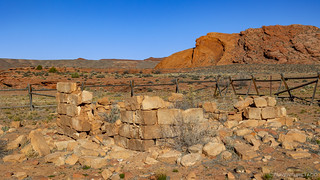
Spanish for corner, Rincone was the name given this bench land which forms a right angle junction of Comb Ridge and the San Juan River. Being a popular site for the fording of the river, William Hyde established a trading post here in the early 1880s to trade with the Indians. In 1885 Hyde's son-in-law and partner, Amasa Barton, moved to the Rincone to run the enterprise. Barton built a log home, warehouse, blacksmith shop, corral and established a garden. For irrigation, water was brought up from the river by a water wheel.
Early one morning in June 1887. two Navajos came into the store and began arguing with Barton. In the heated confrontation that followed, one of the Navajos pulled a gun and accidentally killed his companion and fatally wounded Amasa Barton. Tense hours and days followed the shooting for it was feared that it could lead to a major confrontation. Through the diplomacy of the settlers in Bluff and Navajo leaders, further bloodshed was prevented.
Following the Bartons, cowboys of the Elk Mountain Cattle Company moved in, making this the center Of their operation throughout the late 1880s. Today the walls of the milk house and the platform for the water well (east of here)are all that remain of the trading post. Hole-in-the-Rock Association
Relieved that I hadn't travelled the length of Comb Ridge for this - though, let's be real, I'd really enjoyed Comb Ridge! - I followed the road a little further until I found exactly what I was looking for. There, nestled in the cliff, was Riverhouse.

Found it!

As usual, well sheltered from weather.
Situated under a larger overhang, the first thing that caught my attention wasn't the ruin itself, but rather a pictograph drawn onto the sandstone wall above the dwelling. A bit more curvy or wavy, it wasn't identical to the one over Moonhouse, but it was darn close.

A similar pattern to the markings over Moonhouse.
Perhaps this dwelling was made by the same - or at least by a related - family to the one a few canyons away. Perhaps the wavy line had a special meaning - a symbol to ward off evil spirits, or one of welcome? Whatever the relation, it was a cool find as I began my exploration of the area.

This dwelling was clearly multiple stories.

I wonder if the original residents appreciated the orange glow of the cool sandstone as much as I did.

Age old cobs, still here after so many centuries.

Pictographs, many of the figures recognizable - crosses, snakes, spirals, and dozens of tiny hands.

Always a favorite, anthropomorphs and big horn sheep.
As one does - or perhaps learns to do - I eventually wandered off from the main ruin, looking for other nearby evidence of its ancient residents. Some pottery perhaps, or even other ruins nearby. I didn't find any of those things, but I did find several petroglyphs etched into the well patinaed sandstone cliff - some of them high enough that they likely required a ladder for creation!

Spirals represented life, apparently.

This triangular pattern as similar to some I'd recently seen in thousands of miles away near Las Vegas.
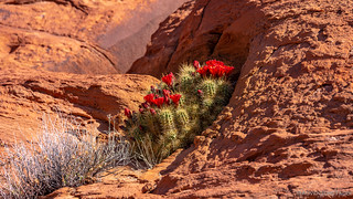
I also came upon this blooming cactus high on the wall!
And with that, I retraced my steps to the truck, took a quick look at the GPS to determine my next destination, and began navigating my way north. From here, I had a few miles of dirt to UT-163, but then I'd have a long stretch of pavement - long enough that I figured airing up was worthwhile.

They should really call slickrock, stickyrock. I love this stuff.

Airing up to cover some pound some pavement; the next few sites were light on the dirt.
A dozen miles east on UT-163 was all it took for me to arrive at my next stop. I knew this one was going to be a bit different then the rest - what with it being a camp ground immediately next to the highway - but I figured I was so close that it'd be silly to not drop in.
The main Sand Island Petroglyph Panel is over 100 yards long, and is part of a series of panels that span nearly half a mile of patinaed sandstone. The rock art found here covers virtually the entire time that humans are known to have inhabited the four corners area. In fact, carbon dating of a sandal found in the showed that this spot was likely occupied as early as 6,500 BC. During each wave of habitation - the early Basketmaker period through the Pueblo III period, new art has been added to the panel. Even in more recent times, the Utes and Navajo left records in this spot that clearly had a special meaning to them.

A literal football field of art.

Newer glyphs, chipped in on top of the older, patinaed art.

An interesting mix of old and new. Patinaed art is old, but a man on a horse and the letters AE are likely much newer additions.
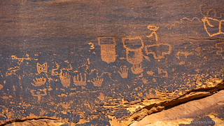
A series of hands. I found the differing number of digits, intriguing.

Coyote?

I really liked this group of deer, big horn sheep, and a frog.

There were several examples of an anthropomorph with three lines above its head.

Bighorn sheep, always a popular muse, it seems.
I think most people only really check out the main, well-signed panel that the BLM has fenced off and directed traffic towards. If you visit, I highly recommend walking the entire cliff side - from the large panel to the campground entrance - to enjoy the glyphs spread out along its length. They aren't nearly as prolific as the large panel, but they are nonetheless striking, and worth a few minutes of time.

Geometric shapes from a nearby panel.
Even exploring the nearby panels, the entire stop at Sand Island probably didn't take more than half an hour or so, and soon I was cruising my way back west on UT-163 towards Mexican Hat. I didn't know much about this section of road, except that following it would take me to Goosenecks State Park, so when I realized that my view for much of the time would be of the Valley of the Gods, I was quite thrilled - enough that I found myself a little perch along the way to snap a photo.

An unexpected delight.
Where UT-163 meets UT-261, I had a decision to make: head for Goosnecks first, and Mexican Hat (for fuel) second - to ensure a topped off tank as I continued on my way - or swap the order and save a bit of backtracking. I mistakenly opted for the former, thereby retracing my steps a few times in order to keep an extra half gallon of fuel in the Tacoma.
Obviously, it didn't matter all that much - I think we're talking something on the order of six miles of backtracking - so I tried to put it out of my mind as I pulled up to the Goosenecks entrance station. It was $5 for a day pass - about 23 hours and 45 minutes longer than I'd need - but it didn't take me long to feel like the entrance fee was money well spent.

Meandering.
The meandering pattern originated several million years ago when the San Juan River was flowing on a relatively flat plain. It became entrenched when the entire Colorado Plateau was slowly uplifted. Cutting downward, the San Juan followed its initial pattern, a process that - obviously - continues to this day. It's a slow process though - there's only about 7 inches of rain here, annually!
With nothing else to do at Goosenecks - literally, the park brochure states "Please note: There are no hiking or bike trails within the Park. Intensely hot during the summer months, there is no shade." - I headed out just a few minutes after pulling in. With a wave to the attendant, I headed south towards Mexican Hat to fill up the Tacoma and snap a few photos of the photogenic rock that gives this place its name.

I had no idea that there was an actual rock that gave this place its name.

An upside down sombrero?
Now, had I made it to Lewis Lodge on the first day of this trip, Mexican Hat would have been my last stop before pointing the truck north and heading home. However, given that it was only a bit after noon, that I hadn't made it to Lewis Lodge on the first day of the trip, and that I hadn't seen any snow on the trails I'd travelled so far, I'd hatched a plan the previous evening to work my way north on UT-261 in order to give Lewis Lodge one more shot.
I'd approach it from Bears Ears, via the route - one may recall - I'd been told was impassable. Hopefully, everyone was wrong.

This was the reason I'd attempted access via Hotel Rock.
If nothing else, the drive north was fantastic. Initially heading past Valley of Gods, I approached the Moki Dugway with incredulity.

The road goes up that cliff, somewhere.

Switchbacks and an 11% grade.
Upon reaching the top, the skyline opened up and there in the distance was a landmark I knew well - Bears Ears National Monument. As the road undulated up and down over the rolling landscape, the buttes grew larger and larger, the lack of snow not lost on the guy behind the steering wheel.
Note: Visiting Bears Ears National Monument requires a pass. For more information, check out BLM Utah Cedar Mesa Permits and Passes Information.

My confidence was building.

I was going to make it!
My confidence continued to build as I climbed up Maverick Point Road - not a lick of snow to be seen, and the roads - which I knew could be impassably slick in muddy conditions - were dry as a bone. It was only about a quarter mile below the summit that I realized every view I'd had so far - and the road over which I'd been travelling - had been from the south. Of course there was no snow on this side!
And then, I crested the summit. Uh oh.

Was I going to make it?
Flipping the truck into 4WD, I continued on cautiously. There was nothing about this snow - only 1-6" deep at this point - that would pose any sort of problem, and the road underneath was muddy but not overly slick, so I continued on. And then, about a mile past the summit I crested a small rise and my heart fell.

Well, this is a problem.
I knew immediately that this poor Ford hybrid was stuck - there was no way it couldn't be. My initial thought - to throw it in reverse and head out the way I'd come - was strong, but stronger was my understanding that this person could be in real trouble - and there were few (if any) in a better position to help than me.
I stopped the truck, tromped through the snow, and introduced myself. The relief on the 67 year old woman's face was obvious. She hadn't been stuck long - luckily - but there was no way she was getting out under her own - not with a tupperware to dig, and front wheel drive.
I asked her where she was headed, and her answer - "Bears Ears" - was unfortunate. "Oh man," I said, "You passed it a mile ago!"
Turns out, it was a situation where directions given via Google Maps to Bears Ears National Monument result in a destinatino at the middle of the monument, rather than the actual Bears Ears. With a little understanding - or even reading of signs on the side of the road, rather than blindly following the GPS - this entire situation could have been avoided.
Completely high centered on the flat underbelly of the vehicle, I spent the next two-and-a-half hours with a shovel, USActionTrax Recovery Boards, and a tow strap getting her pulled out and to a spot where she could turn around safely.

Not an easy extraction.
After a lengthy recovery, and the subsequent clearing of the road, I was able to continue on - for about another half mile or so until the road became impassable for me as well - this time, due to mud. 
I'd failed at reaching Lewis Lodge, again! The third time was most definitely not the charm. (Though, I suppose it was good I'd made the attempt.) And so, tail between my legs, I barreled back down the way I'd come - all the way to UT-95 where I'd turned off onto Maverick Point Road. I had one more trick up my sleeve, one more shot at redemption: I was going to attempt the same route to Lewis Lodge that we'd tried nearly two years earlier!
That meant a few miles of pavement - east on UT-95 - through the Comb Ridge road cut and to Cottonwood Wash Trail. This, I knew from experience, was a nicely graded road - so even though I was getting a late start, I hoped that if I did finally reach the trailhead, I'd have just enough time to complete my mission before heading for home.
As I climbed up Cottonwood Wash, I eventually turned west onto South Elk Ridge. So far, things were looking good - there was no snow to speak of as I climbed through 6,500' and the location we'd previously been stopped in our tracks.
Our turnaround point in 2019.
With each hundred feet of elevation - I had to make it to 8,000' before my turn off on Milk Point Road - I waited to see snow. Again and again, I was surprised and delighted that none of the white stuff was present on the trail. And then - my turn off! It was all downhill from here until I reached the parking area with a huge grin on my face. It was a little after 4:00pm - plenty of time to scramble my way down the side of a canyon, I hoped.

Well hello there, what good taste you have in vehicles!
The trail to Lewis Lodge was slightly longer - but significantly easier - than the previous evenings excursion to Moonhouse. There was really only one spot - a narrow ledge that looked more difficult than it was - that was any cause for concern. And the views - well, they started almost as soon as I reached the edge of the canyon.

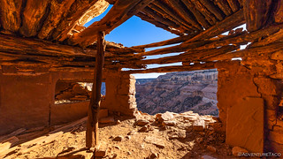
There it sat - high up in the canyon wall - in a seam between the harder, lighter top layer and lower, softer bottom layer of sandstone...

The elusive - for me - Lewis Lodge.

A long way down.
Like Moonhouse, descent to the level cliff dwellings took place on the opposite canyon wall. This afforded me some nice photos, and likely afforded some amount of early warning to residents if trouble was approaching. Making my way around to the main ruins, several smaller structures caught my attention.

Appetizer ruins.
Eventually, I reached an entrance wall of sorts. Built across the entire width of the ledge, a single pathway allowed access to the main structures. I must say, it was unnatural to step on and through this structure - so trained am I to keep off of these historic ruins.

The way in.
On the other side of the gate, the thing I was most struck by was the sheer size of the land mass that Lewis Lodge covered. The ledge extended for a good quarter mile or more, and in several places was 30 feet deep from the back wall to cliff edge. As expected, many buildings once stood here, though visitation must be relatively high as they weren't in nearly as good shape as others I'd seen. Still, how often does one get to wander through history such as this?!

Inside a kiva; again, shelves built into the smoothly finished walls.
Kiva view.
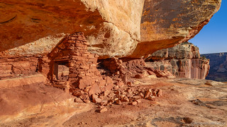
Crumbling ruins.

Protective covering.

A village.

Watch your step.

Sunstar through stone.

Morteros - only a few of dozens overlooking the valley.
The ruins weren't the only thing that captured my attention. The canyon walls too were not to be overlooked - not due to pictographs or petroglyphs, which I was slightly surprised to see absent - but due to the sandstone itself!

Swoosh!

Stripes.
I spent a good forty-five minutes poking around the site before pulling myself away to start the journey back to the Tacoma. While it might seem that the uphill return would be less fun, I always find it more enjoyable than the descent as I'm leaning into the hill and thus feel a bit more stable. Plus, there's less route finding and thus faster progress.

Nature's ladder.
It was 6:15pm when I reached the Tacoma - still before sunset, but a little late late to be starting a 21 hour journey back to the Pacific Northwest. Only briefly did I consider spending the night - after all, besides the dark and lack of food stuffs, night driving is quite pleasant - there's less traffic, no daylight wasted, and a fabulous reward at the end of the journey.

Heading down and out, redeemed!
I couldn't believe my luck, really - the trip had been a huge success. With three full days of exploration, I'd accomplished all I'd set out to see - despite several roadblocks along the way.
And I knew one thing for certain as I pointed the truck north and headed toward Moab - there was no way this would be my last trip to Cedar Mesa!
The Whole Story


While at the Lewis Lodge, I read through a packet of information stored in an ammo can at the site. I felt like these several paragraphs were worth sharing, but didn't know where to put them in the actual story:
I am amazed at all the petroglyphs, I always wonder what they mean. It is amazing what people will do in a town vehicle, what was she thinking? oh yeah right, she wasn't. Good job brother for getting her out. A few years ago two people in a minivan trusted their GPS in the Owyhee mountains and go stuck, the lady stayed in the van and the guy thought he would walk out but no luck he died trying.
I ran into a Prius in on a crappy dirt road in the Owyhees and told him to turn around and get back on the highway that this is no a place for a yuppie car. I am totally amazed at what some people will do.
On a better note, I love your night photos, have you ever tried light painting? An incandescent sends out a soft yellow light and an LED is a bright white light. I have done lots light painting out on the Leslie Gulch road.
Happy Trails!
The petroglyphs are fascinating, for sure. It would be great if there was some sort of written record/dictionary of their meanings, but perhaps the mystery is just as fun, ultimately. Will be interesting to see if the same is true of our writings, way off in the future.
I've done a bit of light painting, but I'm by no means an expert. The next trip I'll post was down to the Black Rock Desert, and I took a few night shots there that were fantastic, so keep an eye out for those ?.
And speaking of the Owyhee's - we're just back from a few days on the west side of the river. Much more barren/remote, it seems - though we did find a ton of cool stuff over there to keep us busy. And a few roads along the river that were too narrow for a Tacoma. Oh, to have an ATV at times. LOL.
Safe travels!