
Where did we leave off? Oh yes, ...as we pulled out our Kindle Paperwhites and snuggled down in the comforters, I looked at @mrs.turbodb and mentioned to her that if the cloud cover brought rain during the night, we should probably get ourselves out of bed and make a run for the plateau - so we weren't stuck here should the road become impassable.
We dozed off around 8:30pm and slept soundly until 12:04am - when the pitter-patter of rain on the tent awoke me from my sleep...
Not the least bit thrilled with the situation, I shook @mrs.turbodb awake. "It's raining," I said, as I hunted around for my headlamp and sweatshirt. "What?" she said, still mostly asleep. She got the picture pretty quickly the next time I said it though, and soon both of us were hunting around for our clothes, neither of us really wanting to believe that we were going to drive out in the middle of the night.
"Should we just stay here? Worst case is that we can't make it out tomorrow, and we just need to wait an extra day or so here for things to dry out." I said as I pulled on my pants. "Let's do that." was the reply I got - and I think it was a relief to both of us, the thought of more sleep a strong lure. So, it was off again with the clothes, and back under the covers - perhaps five minutes having passed since the rain had started. A few minutes later, as I was dozing off again - light rain is such great white noise - the pitter-patter stopped, never to resume for the remainder of our trip.
Thank goodness we hadn't decided to leave!
And, we couldn't really complain about the view out of the tent in the morning, either.

Having gone to bed reasonably early, both of us needed to go to the bathroom, and there's no better time to do - in my opinion - that at sunrise. You know, because the best view from the worlds awesomest outhouse is at sunrise or sunset. Next, we took the opportunity to head on down to the hot spring and enjoy them with steam rising up into the cool morning air - and just a little bit of color bursting from the horizon.

The sun was a little higher (obviously) as we headed back to the Tacoma, the high clouds now softly illuminated with a purple glow. These are the moments that make me glad to be a morning person.

However, as great as the early morning may be, 5:30am is too early to start the day on a trip like this, so we climbed back into the tent - under what were now essentially clear skies - and promptly fell asleep for another 90 minutes. When we awoke again a bit before 8:00am, more clouds high clouds had rolled in - a pattern that mirrored the days before - a bit of a bummer after such a peaceful sunrise.
Knowing that we'd have no trouble getting out, there was less urgency as we packed up camp and ate heaping bowls of Cheerios for breakfast. The good folks on the east side of the river were just beginning to stir as we got the Tacoma turned around and started back the way we'd come, up and out of the canyon and onto the high plateau.


With flat-and-cloudy skies and the sun to our back as we continued to climb were a good reminder to me that it's always better to stop and take a photo whenever one presents itself - never wait for "later," because you can always take one "later too." In our case, we should have spent the time the previous day to photograph our trip down into the canyon, when the (afternoon) light and poofy-clouds-in-the-sky were significantly more cooperative.

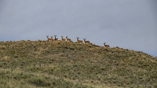
Halfway up or so, a group of deer bound up onto the road. Content to watch us from there as the truck moved forward, they quickly scampered to higher ground as I brought it to a stop for a photo. C'mon deer! We continued on.

By 9:30am we'd passed through the gate at the top of the climb and pointed the truck west. We'd planned to use the better part of the day heading that direction - all the way to Highway 95 and then on through the Alvord Desert to the small town of Denio, Nevada, where another adventure awaited us. But, I'm getting ahead of myself.
You see, here in the present - where we sat on top of the plateau, we actually had four directions we could go:
- Back down the way we'd come - to the hot springs.
- North towards Rome - the way we'd driven in the day before.
- West towards the Alvord - our planned route.
And south. A road that we hadn't planned to take. A road that was - as far as I was concerned, unknown. We headed south.

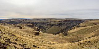
Now, I'd be remiss if I didn't also add that we could see the road to the south was a reasonably short one according to our offline maps in Backcountry Navigator XE. And, it seemed to terminate at a meander in the North Fork of the Owyhee River - a place where the river essentially loops back on itself as the result of running into some harder-than-everything-else-around rock in its path.
In less than a mile we arrived at the overlook. It was in fact a meander, and if we'd had an extra 90 minutes - yes, those same 90 minutes that we went back to sleep - we could have hiked down to the lower plateau to bask fully in its glory. As it was, we admired the view as best we could from our high location.
As we walked back to the truck, we also noted - as is often the case in places like this - dilapidated fire rings and evidence of previous campers. It was a nice place for sure, but we both remarked that there'd be no reason to ever camp here - the nearby springs offering so much more with relatively little effort! And with that, we pointed the truck west, continuing to follow Skull Creek Road to its western terminus, halfway to Highway 95.
The land here was monotonous. Rolling hills and flat plateaus; sagebrush and grass; rocks and mud. We pushed forward, distracted only now and then by cows chewing their cud, the calves skittery as the Tacoma drove by. Gradually - over the course of a couple hours - the road started to improve, and our speeds started to pick up. Still, the landscape around us was the same.
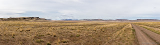
Glorious monotony.
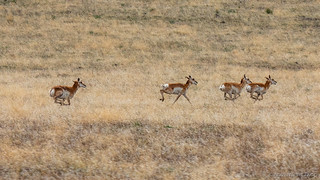
And then, to our left, we caught sight of four pronghorn just as they too caught sight of us. Hemmed in by the road on one side, and hills on the other, they paralleled the road, covering ground at a cool 40mph for more than three miles as we chased along side. It was a beautiful sight to see - one where we just happened to be in the right place at the right time!

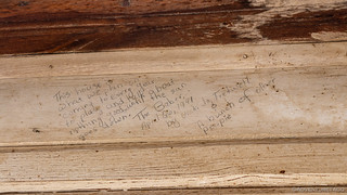
Not too long after our race with the pronghorns, we found ourselves at the old ranch - one that we were unable to determine the name of.

Perhaps it was Beber Ranch - matching the road we were travelling of the same name, or Eiguren Ranch - matching a small plaque nailed to its wall. Whatever its name, one thing was clear - it had gone unoccupied for decades, and yet it was clearly loved by many. Its condition - especially the interior - was better than 95% of cabins we've encountered on our journeys; the notes scrawled lovingly on the front wall by repeat visitors were a testament to the effort and good times they'd had there.


We spent a good amount of time looking around the ranch - inside an out. With two outbuildings, there was plenty to see, and we enjoyed it all - the sun just now starting to win its daily battle against the clouds in the sky. We also encountered two of the ranches current residents - one of the blackest lizards I've seen, and a small squirrel-like creature, burrowed into the wood bin on the front porch - hoping that we weren't going to eat him for lunch!

Leave me, I am mini-dragon, king of the ranch chimney.
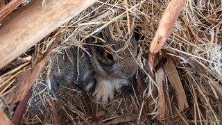
Maybe they won't see me if I just sit very still.
Of course we weren't going to eat him for lunch - but that didn't mean it wasn't getting on toward lunch time - and we decided that we'd look for a good place to eat in the next hour or so as we continued west, the familiar Steens Mountain rising up in the distance.

It was right around 12:30pm when we finally popped out on Highway 95 and made our way a few miles north to Whitehorse Ranch Road - a gravel superhighway that we've travelled several times on previous excursions in the Alvord Desert. This route would deliver us most of the 55 miles southwest that we had to travel to the teeny tiny town of Denio, Nevada - but not before we stopped to eat lunch on a bluff overlooking Steens Mountain and we-know-it's-there-but-can't-see-it Alvord Playa.
We pulled into Denio just before 2:00pm - the furthest south we'd ever been on the Fields-Denio Road and snapped this picture of what was essentially the entire town.

The entirety of interesting things in Denio, Nevada.
Now, the entire reason that we were in Denio in the first place was that it was the jumping off point to a destination to our north - in Oregon - that was only accessible from here in Nevada: Propeller Meadows, the site of a B-24bomer crash in 1945. At an elevation of 7000+ feet, we had no idea if we'd make it to the crash site, but I knew we needed to try.
Almost immediately we were distracted. An old, abandoned, copper mine a few hundred feet off the side of the road caught our attention and we pulled in to take a look.
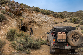
The "decoy" shaft that we spotted from the road, and that drew us in.

The main shaft. 50 feet deep, with a 15 foot diameter.

Kazow!
Continuing on, the road to Propeller Meadows was better than I think either of us expected. Part of that, surely, was due to the fact that much of it is currently used for ranching. Some of it, also, is likely due to the fact that nearly the entirely of the road is on the southern exposure of the Pueblo Mountains, enabling it to stay warmer and drier than a similar road on the shadowy north might fair.
Here and there we would cross springs as we made our way up, the view behind us getting better all the time.


With less than a mile to go, we ran into our first snow drift. Luckily for us, it was easily bypassed - otherwise its slushy depth of 18" would have meant we were walking the rest of the way.

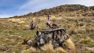
And with that, we'd arrived. High along the ridge of the Pueblo Mountains, the 75-year old remains of a WWII plane, that crashed on February 2, 1945 - a clear night - scattered across the landscape. Eleven crew members lost their lives. A few years ago, a group of adventure motorcycle riders placed a plaque at the site to remember the brave men who gave their lives for our country (full trip report).

I forget exactly how I'd learned about this accident site, but however it was, I wasn't able to find a great deal of information available about it online. Luckily - and completely coincidentally - Craig over at AviationArchaeology.com happened to contact me on another - non-plane related - topic a few days after we returned from the trip and I asked him if he'd been there. He hadn't, but he did have some spectacular information to share, including the full 60-page accident report taken by the military at the time.
![This aircraft took off at 1744MWT on a "Round Robin" navigation training flight from Gowen Field, Idaho to Hamilton Field, California to cruise at 12,000 ft and 11,000 ft respectively. On the return leg of the trip, as the aircraft approached the vicinity of Denio, Oregon, 165 miles SW of Gowen Field, at approximately 2200MWT, with weather CAVU, a nearby rancher observed it to proceed normally in a northeasterly direction and fly over the crest of a mountain ridge located 5 miles from Denio, Oregon. According to his statement, he continued to watch the aircraft, saw it make a turn and head back in the same direction over the route it had just come. As the aircraft approached the top of the mountain ridge again, it was seen to pull up sharply in an apparent effort to gain altitude and clear this mountain ridge which was directly in the immediate flight path of the aircraft. After just barely clearing the top of this ridge, the aircraft was then observed going into a dive out of sight beyond the ridge. A few seconds later, the roar of the engines stopped and a bright flash lit up the sky which indicated to the rancher that a crash and explosion had occurred. He secured the assistance of a neighbor and together they proceeded up the mountain in an attempt to reach the crash. Due to darkness and terrain, they were unable to reach the scene until daylight. After inspecting the wreckage and nearby vicinity for any possible survivors, of which there were none, they came back down and made their report which was turned in to Gowen Field. Examination of the burned wreckage by the Accident Investigating Officer, evidenced a terrific impact caused by [a] head-on collision with a rocky shelf of the snow-covered mountain peak at an altitude of approximately 7500 ft which resulted in disintegration of the airplane and instant death to all crew members. Further examination of parachute harnesses worn by the crew members revealed the fact that none of the parachutes were snapped on; thus presenting further evidence which would indicate no occurrence of trouble prior to the crash. The #'s 1, 2, and 3 propeller governors were removed from the wreckage and taken to the local Air Corps Shops for examination and testing. All three governors were found to be set to control engine RPM at approximately 2500. There was no evidence of mechanical failure. No. 4 governor was damaged and burned to the extent that it was impossible to determine the RPM setting.](https://live.staticflickr.com/65535/49860142861_455f0a86ac_n.jpg)
Army Air Force incident description.
![It was about 9:15 on the evening of Feb. 9th when I left the main ranch house to retire to the bunk house. I heard the sound of an airplane flying above but did not see it. I then went into bed and a few hours later Mr. Burke Hollowny drove up and got me out of bed saying that an airplane had crashed up on the peak back of Denio. We then came to Denio and got horses and proceeded to climb up the mountain about four o'clock in the morning we got within about a quarter mile from the wreck which [we were] unable to see but we could smell the smoke. Due to the deep snow and high wind, we were unable to go any further, so we waited for daylight. At daylight, we were able to reach the wreck. We looked around as best we could but did not touch anything. We could see four bodies. We then came back down to Denio and reported what we saw.](https://live.staticflickr.com/65535/49860454142_d803ed6542_n.jpg)
Eyewitness account from Harvey A. Wise of Denio, NV.
We spent some time walking around the site, contemplating the various bits we saw strewn across the hillside, wondering what could have caused the situation to occur.

One of three radial engines still on the site.

A landing gear. Note the discolored piston in the center of the image.

Engine internals.
Another engine.
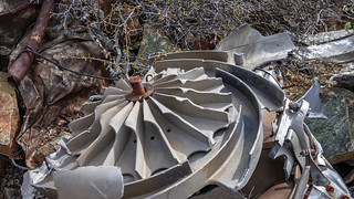
A supercharger.
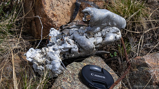
Melted aluminum; the fire was intense.
After exploring the crash site, which was just below the ridgeline, we wondered what would have happened if the pilots could have gained that last 150 feet of altitude they'd have needed to clear the ridge, so we made our way up to a rocky outcropping to look east. Smooth sailing all the way to the Alvord Playa, where perhaps they could have set down in a more controlled fashion.

Looking northwest from the top of the ridge.

The view back down to Propeller Meadows.
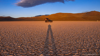
Our exploration complete, we made our way back down to the truck and returned to Denio via the same winding route that had delivered us high into the Pueblo Mountains. The terrain familiar now, we made excellent time and it was 4:00pm when we put the last of the bumps behind us and aired up on the side of Highway 140 before turning north towards Fields and our designated camp spot for the night - the Alvord Playa. An hour later - and with the fuel light on - we swept around the broad turn that marks the southern end of the playa. As always, it was a beautiful sight.

While I took a few photos, @mrs.turbodb pulled out her binoculars to count the number of campers already spread across the flat surface. There were the most we've ever seen - even on a weekend - with 24 groups claiming their own little slice of the lakebed. We made it an even 25 as we found one of our favorite spots right under Steens Mountain. Or odd 25, I guess.

While the location was familiar - the Alvord Desert being one of our favorite spots in the Pacific Northwest - the lakebed surface was different than we've ever seen it. Usually the surface is flat and nearly white - nearly devoid of any moisture whatsoever. This time however, it was clear that it had only recently become drivable - the crackled edges of the surface pulling up and away like so pieces of confetti.


The skies overcast and the winds in the 15mph range once again, we had a quick dinner of hot soup and read our books for a few hours (in a noisy tent) before brushing our teeth and putting in our ear plugs. We hoped that the forecast - winds stopping around midnight - was correct as we were rocked to-and-from sleep atop the back of the truck.
The following morning...
The winds did eventually die down a bit, but it was definitely our windiest night of the trip - understandable I suppose with such an exposed location. As morning light came, I kept looking out the door of the tent for that orange glow on the horizon, surprised as the time got later and later and there was no such light. Turns out I'd estimated the location of that light by about 90° on the horizon, and by the time I realized my mistake, I'd missed my opportunity. Even still, the location leaves little to be desired even in that case, I'd say.

Always a great place to wake up.
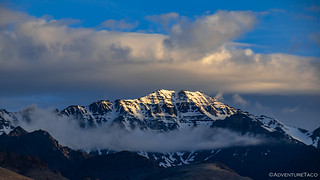
First light on Steens.
I waited a final few minutes for the sun to finally hit the playa before climbing back up into the tent.
Our last morning out, we'd spend most of the day driving home, but there was no need to rush - surely we could enjoy a couple more hours here in paradise, the sun warming us in the tent.
The End.


Another great episode. The 24 campers reminds me of last year in Wyoming. We took what looked like a fairly unused track from Atlantic City to Lander. Every little nook and cranny had a fifth wheel parked in it. This went on for about 30 miles. We finally found a spot to camp but it was not ideal. Some of these folks leave their trailers and just use them on the weekends.
It is getting increasingly difficult to “ get away from it all” unless you have a rock hopper which I do not.
Beautiful. The pictures are amazing, and your writing is so enjoyable
Cool headstone multiple marker!
And the mini dragon ?
Not to mention all the side adventures.
Great storytelling!
Another great write up! Thanks for sharing.
Hello, I was in the large black Ford van you met as you were coming down from the crash site, it was very helpful having your tracks to confirm I was on the correct road! Got a little sporty in the big van, 4x4 low wasn’t low enough coming back down! ?
Great trip and nice write up!
Hey, awesome - so glad you found the post about the trip. Was great running into you on the trail, and I hope you enjoyed the site as much as we did. I can imagine that the van could have gotten interesting there - even we were a little off-camber at one point.
Have fun out there!
Awesome report. I've done my fare share of tooling around in that area. Did you stop by willow hot springs? How was your drive up out of Three Forks? I had planned to drive it out last time i was there but reports said it was sketchy. Doesnt look to bad to me though LOL. Full size chevy 33s limited slip.
Thanks Keith, glad you enjoyed it! We didn't stop by Willow Hot Springs on this trip, but have in the past - check out Alvord Desert 2 - We Don't Want to Pull Anyone Out (part 2 of our Alvord Desert - We Return to Explore trip).
I'm not sure how getting to Willow could be sketchy - seems like Whitehorse Ranch Rd. is essentially a highway, LOL. Keep on enjoying the trips, and by all means, Don’t miss the next adventure!
Sorry but I was talking about 3 forks how’s the East side
Ahh, East side to Three Forks was in great shape. We saw a lot of folks come in that way - no full size, but some 2nd and 3rd gen Tacomas made it in with pop-up campers so I bet you'd be fine. Just that final descent down to the water that's a little narrow and off-camber would be the only sketchy part. Take it slow and I'm sure you'd be fine.
I have been going to Three Forks nearly every year since the mid 90's. Great place, but nowadays getting pretty busy. Came down the west side in 2005. At that time, you could barely see that there was a road near the top. Grass as high as the hood was growing there. The grass was a different color where the road was otherwise you would have been lost. Now it is like a freeway and after last trip, not sure how many more will be in the future. Just too much traffic.
When we came down in 2005 we camped at the same spot you did.
I tried to get to the crash site a few years ago. Unfortunately, it was snowing pretty good when we got to Bog Hot Springs. I was going to drop off the trailer there and then continue on. Figured we would not make it with the snow though, so we just stayed and enjoyed the hot spring.
We did get to drive on the Alvord with about 3" of water on it on that trip. It was a hoot!
Fun read! Thanks! George.
It'd have been great if I'd discovered this whole area in 2005. Shoot, I was still 11 years away from my first trip in the Tacoma though, so I suppose knowing it "before" was sort of impossible. Gotta love work/career, hahaha! (Not that I can complain, given that I'm now able to do this to my heart's content.)
There is quite a bit of traffic now, and it's only getting worse. Alvord is the same way, though the playa is big enough that quite a few people can be there and you can still feel like it's not too crowded.
The crash site (IMO) is worth visiting. The snow does persist quite a while into the spring and there are a couple steep climbs that stay soggy until it's gone, but at that point, getting to the memorial is quite moving. If you have a chance to try again, of course.
We've not been to Bog yet; were planning to visit on our last trip to SE Oregon, but weather intervened, and we headed home. Just another reason to return, as if there weren't enough already!
Yes, Alvord was pretty unknown in the 90's except for the wind car group. We pretty much had the whole area to ourselves back then. The road through there was similar to railroad bed rock and was murder on tires. I think that alone kept a lot of people out. Last time in I was doing 45 and felt like pavement. It was a real treat to drive last time in on the water. Very strange sensation in a vehicle and beautiful. You can check it out in the Have You Steen It! series on my channel.
I visited a crash site near Whickahoney a few years back. I found out later that two airman lost their lives in that crash. Made for a lot more emotion and respect for the area. My Grandfather use to own Grasmere, Id back in the early 70's and I remembered them talking about that crash when I stayed there as a young child. My dad had always wanted to go find it; he never did. I finally found it with my daughter a couple years ago. Stage Road and Fighter Crash on my channel. George.
Speaking of plane crashes in the area - have you visited these two a little further east?
I know of them, but have not ventured over to see them as of yet. On the Bucket list for sure. Thanks for the trip report. George.
Do you have the grid coordinates for the plane wreckage in OR. My paternal grandfather, Anton Pecnik , was the flight officer. My oldest son lives in southern Oregon and we would like to try and visit the site.
Hi Nathan,
In general, I don't share GPS coordinates directly. This is an approach that I've come to over the years after more and more sites become overrun when it simply becomes too easy for the masses to find them.
I've outlined my approach, here: Do You Have a GPX for That?.
I will say, I do make exceptions in some cases, and yours - should it pan out (apologies, but it's so easy to say you're related to a flight officer on the plane) - is one that I would like to help with.
Feel free to contact me via the contact form on the site, and we can go from there. 👍
Thanks for the reply, I understand your concern. I was hoping that my antique email address would help to verify my identity. My father James Pecnik was Anton Pecnik’s son. I’ve never met anyone else with the last name. I’ve been doing genealogy research and came across several articles and videos and the wreck. I’ve reached out to Scott Thomas, the archeologist that did the original dig of the site hoping that he can guide us to the site. I found the coordinates after reaching out to you. They were in his original report that DOD sent to us.
Ironically, my oldest son moved to OR and is about 300 miles from it. My dad is still alive and lives in FL. I’m trying to get him to make the trip. We had four generations at the Arlington funeral. My grandmother passed since then.
I’m hoping that my two sons and my dad can make the trip together.
Nathan