
The wind that had picked up just as I went to bed continued all night. In fact, it stopped nearly on cue as my alarm went off just before sunrise. This was actually fine by me - I hadn't been bothered all that much by the wind, and it would be nice to have a calm day as I was out and about.
I wandered away from the Tacoma - stretching my legs and admiring the nearly cloudless sky above - as the sun finally broke above the horizon.

While I'm not usually a fan of freezing temps overnight - I'd much prefer milder weather - the mid-20°F air had left behind a nice side effect: all of the sloppy mud was frozen solid. I decided to skip breakfast and get underway in order to take full advantage!


I got a good several miles behind me - rolling up and down through the hilly landscape - the going so much easier than the previous evening. Despite the nagging in the back of my head of snow on the mountains in front of me, my confidence level - for the time being - that I'd make it through the route was increasing dramatically.

A herd of deer crossed the road in front of the truck and once they got to a safe distance, they seemed as curious about me as I was about them. Our standoff lasted a good several minutes, before I climbed back in the truck and continued a little further down the road.

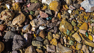
Soon however, I was stopped again. This time, I'd spotted an interesting outcropping of rocks to my south and I figured I might was well explore them a bit - after all, slowing down and enjoying where we find ourselves - vs. rushing to complete as many roads as possible - is the best reason to do a trip like this.


My first destination for the morning was a hike at Three Fingers Gulch, so after getting my fill of rocky formations, I continued to make my way south - to what would be a 5 mile hike that I hoped to complete before lunch. Again, it was up and down through rolling hills - a really pleasant drive, save for the cow shit everywhere - with the roads still frozen into a nearly-paved condition.


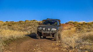
It was still before 9:00am when I started my descent from the plateau down into the Three Fingers Gulch area. The sun had been out long enough now - a couple of hours - that parts of the road were starting to thaw, but it was still plenty solid enough that I had nothing at all to worry about from a traction point of view. I had no idea if that would be the case later in the afternoon, but took solace in the fact that if traction became too poor, I could always wait for the following morning to drive out when it was frozen again.


With the Tacoma parked at a nice little camp site at the end of the road, I gathered up my camera equipment, a bit of water, and no snacks - an oversight on my part given that I'd already skipped breakfast - and set off down the gulch towards a finger of Lake Owyhee.
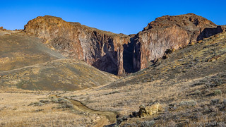
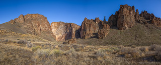
On a map, this gulch - a great fissure in titanic rock - appears to be the primary drainage of Three Fingers Caldera. According to recent radiometric dating, the caldera spewed ash and lava fifteen million years ago to create much of the fascinating topography I was seeing today. Almost immediately, I spotted an old cave that I'd learned about in my research, and I headed that direction.
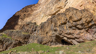
I'm not sure what I expected to find in the cave, and while I was unsurprised to see the ceiling covered in soot, all of the writing on the walls caught me a little off guard. I probably should have expected this as well - humans have a way of not being able to leave well enough alone - but nevertheless, I mumbled some disappointment to myself as I looked around.

Soon, I was back in the gulch, headed down stream, admiring the colors all around. The tall orange cliffs rose up all around me, and the river rock along the drainage was a rainbow of color. Most of the trail was easy going - meandering down the canyon, with only a couple tricky dry falls to navigate along the way.
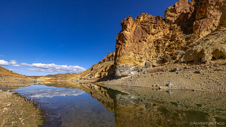
With two-and-a-half miles to cover, it probably took me an hour or so to reach the mouth of the gulch and the shallowest finger of Lake Owyhee that one could imagine. A few clouds had started to form to the north - and all around, really - making for some wonderful reflections on the glass-like surface of the water.

I continued on, the "trail" now consisting an infinitely long scree field that circles the lake, a testament to the low water levels, until I reached the main body. It was tough work and while I was hoping for expansive views, they turned out to be significantly less photogenic than those at the finger from which I'd come. Still, I was still glad to have made the trek as I slipped my way back along the scree field and up the canyon.
It was at this point that I had a decision to make. I could either head back to the truck for lunch, or continue up the canyon from the trailhead in search of two more items of interest that I'd uncovered in my research: a geocache and a wild horse trap.
Predictably, I decided that lunch could wait.


Within the corral, I immediately spotted the geocache. I forget exactly how I learned of its existence, but anyone visiting the area is likely to see it regardless of previous knowledge - its home quite obvious amongst the rocks. Inside, the usual geocache trinkets, which I picked through and admired as I left my mark in the log.


It was 1:00pm by the time I wrapped up my time at the horse traps, and upon returning to the Tacoma, I enjoyed a chicken sandwich, some tasty potato chips, and one of the best Cosmic Crisp apples I think I've ever eaten. I still had quite a few miles to rack up on the odometer before the day was done, so as nice as the warm sun felt as I sat on a comfy rock overlooking the gulch, I stowed things in the bed of the truck and continued my trek south.

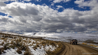
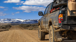
It was at this point that things got just a little bit dicey. For the three hours or so that I'd been enjoying my hike, the sun had been warming the previously frozen roads - drying them some, but mostly - returning them to their gooey state of slime. Wheel spin and plenty of over-steering were the order of the afternoon as my progress slowed. There was even a point at which - had I not known that one of the roads I was about to merge with was a well-graded gravel road - I might have turned back rather than continue deeper into the muck.
Boy was I glad to finally make it onto the gravel of Leslie Gulch Road. I could see where several vehicles had turned onto the road I was exiting, only to stop and back up about 30 feet in, after realizing its condition.
Even so, my victory was bitter sweet. My earlier concern - that my track would take me through the snow covered mountains - was clearly well founded, and I knew that any secondary roads through this area were surely impassable. I could have just re-routed at this point, but I figured I didn't have much to lose by continuing on just a little further.

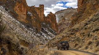
Even as I wound my way down Leslie Gulch and the snow began to thin, I knew it was irrelevant - the trail I'd mapped, climbing to over 8000' after it split off from the main route. Still, I couldn't help but enjoy the views outside the truck, the colorful rocks of this gulch really are some of the most striking in the area.

When I arrived at the road up Dago Gulch, I found it gated and locked. And so, regardless of the snowy conditions, I'd have been re-routing at this point anyway - this, as far as I could tell from my research- the only road that connected from this section of the Owyhee Canyonlands to the Jordan Craters area, without heading east to Highway 95.


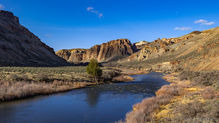
Rather than turn around immediately, I continued down through Leslie Gulch to a boat launch on the edge of the lake. I've never been all the way down this road - having previously stopped to hike at Juniper Gulch - and it was worth the drive, each turn revealing rocky outcroppings of orange, yellow and black.


Having come as far as I could, I headed back the way I'd come, stopping only twice as I made my way to Succor Creek Road and along a short section of Highway 95 in order to re-join my track a little way south.
The first was for a milestone of sorts.
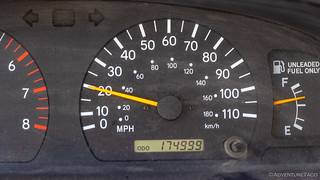
It was less than five years ago that I hit 60,000 miles, and I was at 120,000 some 23 months ago. Lots of great memories and exploration in that time though, so I can't say that I have any complaints about the miles racking up!
The second stop was along a side road up into the snow. I wanted to see what the traction was like had I been able to make a run at Dago Gulch, and the answer - at least once the snow started - was that I'd probably have been OK. The snow provided a layer of protection from the underlying mud, and helped to keep the ground (more) frozen - my traction actually quite good as far as I could tell!

And with that, I adapted to the cards I'd been dealt, the gravel bypass roads making quick work of several dozen miles.
As I mentioned, my plan had been to connect Leslie Gulch at the north with the road that leads to Jordan Craters at the south. Interestingly, as I sped along towards Jordan Craters, I noted that the road I'd hoped to use was not gated on the Jordan Craters side. Perhaps in the future - when the roads are a bit drier - I'll head that direction to see if I can find a way through - it would be a beautiful journey, I'm certain.
For now however, it was getting later in the day and I decided that I'd work my way past Jordan Craters and to the historic Birch Creek Ranch - situated on the Owyhee River - before deciding where to camp for the night.


I think there was a 1900' elevation difference over six miles of dirt road, all of it dry, which was a relief. I was surprised at the condition of the BLM-owned (since 1988) Birch Creek Ranch when I arrived; it's clearly well cared for and still regularly used, for something.


The Birch Creek Historic Ranch buildings and rubble remains give you a glimpse of the earliest Euro-American settlement in Owyhee Canyon and the significant role of Basque immigrants in Malheur County. Evidence of much earlier settlement on the site was unearthed when the Owyhee River flooded its banks in the mid 1990s, exposing artifacts and triggering excitement in the archeological community. Archeological evidence indicates the river setting is located in a transitional area with cultural traditions of both the Great Basin and Columbia Plateau regions.
For approximately 1,000 years, this area was used by the Mono-Bannock-speaking Northern Paiute and Western Shoshone Indians. The cultures consisted of semi-nomadic family groups who traveled independently. They subsisted on hunting, gathering and fishing. Evidence suggests that family groups were small, probably a reflection of available resources. It is believed that spring and fall were used to fish the rivers. In summer and early fall, seeds and berries were collected. In winter some of the Shoshone groups were known to join Flathead expeditions to the Plains to hunt bison. Those who stayed in this area during historic times came together in groups of 2 to 15 families, pooling resources to live on cached fish, roots and seeds, along with some game. BLM Brochure
The road continued for a mile past the main ranch house, and there was no way I was coming this far without driving to the very end! I didn't make it far before a badland-style hill across the river caught my attention, an old barn adding to the intrigue of this old place.


I continued on, the river now seeming to pull me along as the road hugged the narrow spot between the rushing water and steep orange cliffs. And then, to my surprise, I spotted an old water wheel, this one apparently used for irrigation, several buckets and troughs still intact enough to discern their purpose.

And then, eventually, I reached the end of the road. Now a boat launch - or landing, I'm not sure which - there was also a nice field, some fire rings, and the sound of the river rushing by just a few feet away. It was enough to convince me that I shouldn't push on any further for the night - I'd found the perfect place to camp.
And, I had the whole place to myself.

With a couple of hours of light remaining, camp setup, dinner, and a walk along the river were leisurely and enjoyable. Two small planes came barreling through the canyon at one point - too fast and low for me to grab the camera - to add a little excitement to the evening.
It was almost too peaceful as I went to bed - the wind non-existent and the rhythmic white noise of the river lulling me to sleep...


Another incredible trip you've taken me on. Thank you. I wish I was 20 yrs younger so I could cram in all you've shown me .....and do it myself. I am loving this site and these lovely rock infested views that make me drool over wanting to see the real thing. I have sent your site address to my kids and grands because in my family, we are rock-hound-nuts like you are. We take lil trips here and there and take loads of photos. enjoy and please don't stop!!!
So glad you're enjoying Jeannie! There's one more part to this trip that I think you'll really enjoy, but I won't get to post it until Monday since I'll be snapping some more photos between now and then ?. I totally understand the desire to be a bit younger - I'm starting to feel that way myself. But, as long as you can still get out for the lil trips here and there, life is still great! And, even if you're just enjoying through photos, that's better than not! Have fun out there!
Another great ride, the reservoir looked to be low enough the go up the river trail, which is unusual for this time of year. The area where you stopped at the green iron gate at Dago gulch is a short section of BLM. This road takes you up to the top of Mahogoney mountain which is privately owned by a friend of mine, they run their cows on the mountain.
I have ridden ATVs all over Mahogonay mountain, with spectacular views. There is a small runway on top of the cow camp. Not likely it can be reached this time of year though.
Great adventures!
That road at Dago Gulch seems to go all the way through, once it goes up over Mahogoney Mountain. I saw it come in on the other side as I went to Birch Creek, so I hope to explore it from that end next time. You probably know where it's gated on that side as well, don't you. Man, I'm slightly jealous of all your travels in the area! Keep it up, and I hope I do it some justice by you! ?