
As the third rain shower of the night hit camp, we all decided it was time for bed, and the fire got put away as we retired to our respective perches to the pitter patter of raindrops - which, along with the nearby gurgling of the creek, lulled us to sleep.
It rained on and off through the first half of the night, but by morning the rain had passed and the skies were mostly clear - a great way to start the day.

In a depression and with clouds still on the eastern horizon, there was no point in getting up early, so I waited for the sun to hit the tent and then made my way down the ladder - only a few minutes before Ben @m3bassman did the same to let Venice and Milo out for the morning. As I wandered around camp, a bright spot caught my eye in the distance. Downwind, I was able to get reasonably close to a lone pronghorn checking out our camp.

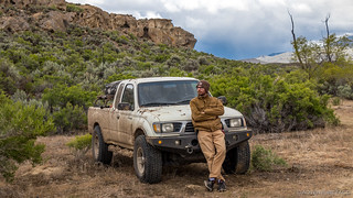
Breakfast and coffee ensued soon after I returned to camp, Mike @Digiratus and Zane @Speedytech7 now up as well. For most of us, it was just the normal routine, though I don't know if that was the case for Ben and Kirsten. It appeared that Ben was getting a cooking lesson.

Tents were good and wet after a night of rain, so we lazied around a bit waiting for them to dry - at least mostly - before stowing them and getting ourselves ready to go. The plan for the day was to fuel up in Jordan Valley, then head east toward Silver City, Idaho. Since we'd attempted the Silver City Road just a couple weeks earlier (full trip) and been turned around by snow, we decided that this time we'd see if we could make it by routing ourselves through the nearby Delamar Mine - something we hadn't had time for on the previous trip.


We covered the 20 miles or so from the campsite near Jordan Craters to Highway 95 in no time, and since we knew the road to Silver City was in reasonable shape - and that if it was unpassable, that the re-route on the Owyhee Uplands Backcountry Byway was an extremely nice gravel road, we decided we might as well air up to go easy on the trucks and allow - a slightly, since I was leading - faster pace on pavement.

In no time, we'd filled up with fuel and set off east into Idaho. In the distance, the snow situation to Silver City seemed worse than it'd been a couple weeks before.

Not long after we started up onto the plateau leading to the Owyhee Mountains - within which Silver City sits - we found ourselves stacked up behind a caravan of 9 or so full-sized pickups and trailers, all obviously headed to the Delamar Mine! We followed along for a while, thinking that - perhaps - we could just follow them in - but a couple miles before the fork to the mine, they pulled over to let us pass. Curious what they could tell us, I stopped to ask if we could make it to Silver City through the mine, and the answer was an immediate, "No."
Well, "Could we go look at the mine?" I asked.
"This is the best view you're going to get," the guy I was talking to responded. "We don't have any overlooks or anything." Then he added, "I know it sucks that Google routes you through the mine, but we've got a lot of equipment working up there, and it's a private road, so we don't allow folks through."
Of course, we all totally understood that, so we bid the miners farewell and then pulled over because we had a decision to make - whether or not to go look at the old ghost town of Delamar, up the Silver City road, before turning around and heading back to the Byway, to scoot around to the east of Silver City, hopefully to make it in from that direction.

Everyone was interested in the ruins of Delamar, so we continued the five-or-so miles up the road to the old town and mine ruins. There is still one resident that calls this place home - at least for part of the year - but otherwise everything here is reasonably run-down, but still fun to explore.


And then, we made what I think we'd all later feel was a bit of a rash decision. See, at this point we were no more than about 7-10 miles from Silver City, but knowing the conditions from a couple weeks earlier, and seeing the snow level much lower than it'd been, I was pretty sure that we'd encounter snow if we continued on. In need of new tires - to say mine are on their last legs is really overlooking the blame I deserve for letting them go so long - I told Ben he could lead and do the snow bashing.
He declined.
Mike also mentioned that he wasn't really up for snow - so without even checking the situation out, we turned around immediately and headed for the Uplands Byway.
Looking back now - we should have at least checked out that road; because if it was clear, we'd have saved the remainder of the day and 150 miles of track. But hey, hindsight and all that - we were on an adventure and having fun!
Plus, even though the Byway is the long way around - at 104 miles - it passes quickly and offers expansive views nearly the entire time. Hard to complain about this route too much!


This would be a good place to mention that just before we climbed up onto the plateau that lends the "Uplands" moniker to the Owyhee Uplands Byway, we'd all been ready for lunch. It was a little after noon for us from the RealTime Zone™, and after 1:00pm for those from Mountain Time. There was just one small problem - snow. They were just flurries, but none of us really wanted to eat in those conditions, so we pushed on, hoping to drive through the flurries to something much more pleasant.

It took a good 45 minutes, but as we rounded a bend just past a reservoir, the sun on a spectacularly green field with snow-capped mountains rising in the distance was exactly what we'd been waiting for. It was lunch time!


It was still chilly of course, but nice to be out of the trucks an in the sun for a few minutes while we wolfed down our sandwiches. Much to the dismay of those who were unable to participate.


Our bellies satisfied once again, it was back on the road with relatively few stops for the remainder of the Byway. Even so, it was 4:15pm when we found ourselves turning north on the Poison Creek Cutt-off towards what we hoped would be our camp for the night. See, at Ben's suggestion, we'd scrapped a second attempt at Silver City in the afternoon - the trip from the east taking a good 3-4 hours round trip from his recollection. Instead, we'd get to camp a little early, and then check out Silver City the next morning.

Camp for us was a few miles up a wash that crossed Poison Creek Cutoff, and as we neared our destination, it was immediately apparent that this was a special place - time and erosion having worked their magic, spectacular slot canyons left for us to enjoy.

It turned out that the exact spot Ben had in mind wasn't going to work - tucked in at the mouth of the slot, it was really optimized for a single truck - but we found a spot that would easily fit our vehicles nearby and settled ourselves in.


Keen to explore the area, we all got ready to go just as a rain shower passed overhead, so it was back into the trucks for a bit of reading, perhaps a bit of napping, and probably a little snacking. Soon enough, the sun was back out and we set off on foot for the mouth of the slot canyon.

I forget who it was, but as we made our way through the canyon, someone mentioned how the sand here was super strange. "It's like a bunch of little balls," they said. It was probably Ben or Kirsten or @mrs.turbodb, and sure enough, after a bit of inspection, we realized it was Oolite.

Oolite is a sedimentary rock made up of tiny ooids that are cemented together. Most oolites are limestones - made of calcium carbonate - formed into spheroidal grains. The nucleus of the grain is usually a mineral or biogenic fragment around which the mineral cortex forms, increasing the size of the grain spherically until it reaches the size of a grain of sand - usually with a diameter in the .5 - 1 mm range.
We continued our hike through the slot canyon, eventually making our way up and out the top (a nice, reasonably rare occurrence with slot canyons) where we were greeted with a splendid view of camp, and winds gusting to 30 mph.


What was really nice was that the winds in camp - below the canyon walls - were much calmer - so we headed back down to setup and relax, the view and light reminiscent of our time in City of Rocks the previous year (full trip).

With an hour or so to kill before dinner, @mrs.turbodb and I decided we'd also go explore the other side of the canyon - there were no slot canyons there, but plenty of cool wind caves, oolite, and fossilized shells were enough to draw us in.


The views of camp from over here weren't too shabby either!


Now hungry for dinner, we eventually headed back down and enjoyed bang-bang chicken wraps around a camp fire that had been personally delivered by our newest cohort - Will @willhaman21. See, we'd burned nearly all our wood the night before, and had been unable to find more in Jordan Valley.
Ben made a call - or text - or whatever those younguns do to contact each other these days - (tic-tac or something? ) - and Will made the couple hour trek down to meet us - originally planning to return home after having a bite to eat and some time around the fire, but as the light left the sky, he eventually deciding to stay the night (thanks Angie!)

With plenty of wood, lots to talk about, and perfect weather, we stayed up late into the night. It was after midnight - for sure - when we finally called it an evening when we headed up our ladders.
I found myself wondering what that would mean for our adventure the next day - would we have time for everything we'd planned? We had a lot of great places on that agenda, but hey, no need to get ahead of ourselves...
The Whole Story


Love Owyhee? Check out
more Owyhee trips
for all the amazing places I've been in and around this special place over the years.
I am amazed at how many not so common places you have been in the Owyhee. I know exactly where you were camped at the end of this day. Pretty cool place. George.
I try to poke around a bit. Still a lot to see, for sure. I've got a northern route between Owyhee and Alvord (I've already done a southern dirt route) that I want to try out later this spring!
I did a trip a year and a half ago. We started in Owyhee, Oregon and came out at Stinkingwater Pass on highway 20. If we would have turned South, we would have come out just east of Crain on highway 78. Nothing but dirt for 3 days. Some of it pretty rough, but it was a lot of fun. If interested it is the "Stinking Water" series" on my channel.
Hey I live in Idaho and want to check it out. Can you send me a pin of where they camped?
Hey Cody, I'm not sure where you're wondering about camping since there are a couple nights of camping covered in this post. Regardless, here's my approach to sharing specific locations and how you can find where we were.
Do you have a GPX for that?
Sorry I didn't mean to be rude. I just have spent countless hours mapping out slot canyons and potential areas within a few hours of Boise. So, I was just intrigued by this. My apologies.
No worries at all man, it's 100% fine to ask, and I think that with the trip report, you should be able to follow the roads and find either of the camp sites (though, it's a bit more work).
That one you're looking for (I know what you're talking about now) is on the east end of the Owyhee Uplands Backcountry Byway.
Have fun finding it, and checking it out!