
I don't know why exactly, but the Alvord Playa holds a special place in our hearts. Perhaps it's because it was the first big playa that we ever drove out onto and camped on. Maybe it's due in part to the history around the women's world speed record and our search for the final tracks left by Jessi Combs after her death there several years ago. At least partially, it's due to the surrounding landscape - full of hot springs, old mines, vast ranches, and of course, the ever-present Steens Mountain.
We've ventured onto Steens Mountain before, trying to make our way - on dirt - over the southern end in order to explore the Steens Mountain Loop, but were turned around by locked gates. What we've never tried to do is explore the flank of this gigantic behemoth that extends 50 miles to the north.
Until now.
Anyway, we got started around 8:00am. With a relatively short 10-hour drive - at least, compared to some of our 20+-hour jaunts - and with the days getting longer, it was still light as we approached southeast Oregon to some very windy conditions.
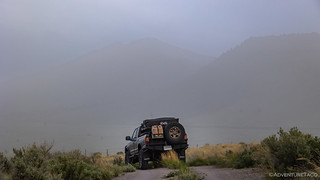
That's not fog or snow, that's dust stirred up by the steady 25mph winds and 45mph gusts!
Luckily, we had one final pass to navigate, and as we dropped down on the leeward side, it was a little less dusty - though definitely not the clearest day we've had - as we sped down Fields-Denio Road toward the Alvord Playa and Steens Mountain.

It might have been a little dusty, but it was also so green!
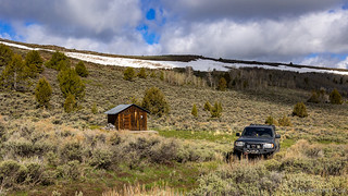
My plan had been to head all the way to the Alvord Playa to camp for the evening, backtracking to Stonehouse Canyon the following morning - where our adventure along the northern slope of Steens Mountain would take place - but from 30 miles away we could see that the playa was a disaster of dust, so instead we opted to nestle ourselves into a spot in Stonehouse Canyon where we hoped to be sheltered from the worst of the wind.

Searching around in Stonehouse Canyon for a nice spot to call home for the evening.

Eventually we found a nice little site off the side of the road; the long spring grass completely enveloping the fire ring that would go unused for our short stay.
After enjoying a beautifully pink-and-purple sunset, we deployed the tent to relatively calm conditions and climbed under the comforters, hoping that the wind would die down even more over the course of the night.
Day 2...
As we'd climbed into bed, the westerly wind and shape of the canyon meant that the majority of the wind was blowing down the north side of the canyon - to the extent that I even commented to @mrs.turbodb that it was "nice" to hear the river of wind running through the trees and grass - while we were in the relative calm in our little eddy.
Around midnight, that all changed. Instead of blowing from the west, the winds became northeasterly and we were suddenly caught in the line of fire. The shaking and buffeting of the tent became relentless, and though I'd secured the ladder with our 5-gallon jerry can of water - so we didn't need to worry about the tent folding up on us - even with earplugs, it was too chaotic for a good nights sleep.
And so, even as the sun rose to the east, I decided to hold off on my usual photos, opting instead for a few more minutes of rest.

Eventually we got up to a beautiful - though still windy - day.
Longer days meant that - even with our lazy morning - we were under way just before 8:00am, headed west up Stonehouse Canyon Road as it climbed the eastern escarpment of Steens Mountain.

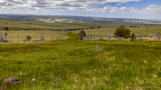
The green grass of spring made all the roads nearly disappear.
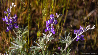
Lupine going strong at the lower elevations.

The basalts of Steens eastern escarpment really remind me of the geology in the Owyhee Canyonlands, not too far to the northeast.
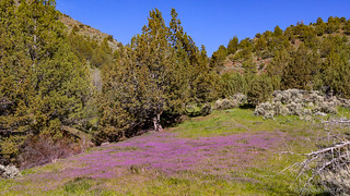
We didn't even get out of the Tacoma to investigate these purple blankets that popped up here and there along our trip, but we certainly admired them from the comfort of the cab!
Eventually, we reached the top of the canyon and popped out along the eastern edge of Steens Mountain. This mountain - the largest of Oregon's fault-block mountains - rises from the west side of the Alvord Desert Playa and stretches more than 50 miles to OR-78. A single mountain, rather than a range, Steens is shaped like a shallow wedge - the northern end feathering into the landscape at 4,200 feet, the southern end rising dramatically over the playa at 9,738 feet.
Where we'd popped out at 6,375 feet, we crossed our fingers that the patchy snow would stay patchy, allowing us to explore the middle-elevations of this amazing place.

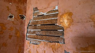
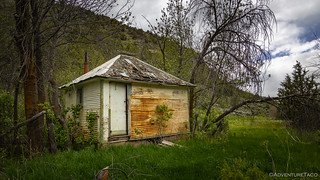
Before long, we came to our first cabin.
Every cabin that we came to was interesting in one way or another, and this one was no exception. While it wasn't in great shape, it was obvious that was someone (or someone's) who was trying to keep it from completely disintegrating, some newer lumber now supporting the opening in the stone where the door once hung. The door itself was inside the cabin, and affixed to it were two patent deeds of the surrounding land, signed by the presidents at the time - Calvin Coolidge and Woodrow Wilson.


Not originals, but I've never seen a patent deed at a cabin before, so these were a great find!
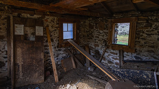
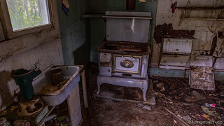
The rest of the cabin interior was a little worse for wear.
With little to see, we were soon on our way. Climbing a few hundred feet in elevation - just enough to traverse a couple of snow drifts - we passed through the second of what would end up being a dozen or so gates over the course of the day, much of this land a mix of leased Bureau of Land Management (BLM) and private holdings. A few minutes later, we were dropping down into a meadow that contained our second cabin of the day!

I have to say, a smile crossed both our faces when we saw this sign.

This second cabin was once much more elaborate than the first, but is quickly deteriorating due to lack of attention.
Lathe and plaster - this was a fancy place!

Outside, even with patches of snow on the ground, spring was breaking through.
After wandering around the second cabin for a while - checking out some of the graffitied names and dates on the interior - we were back in truck for less than a mile when we stumbled upon our third cabin. I'd not noticed this one as part of my route planning, so it was with a bit more excitement that we climbed out to inspect the situation.
A small hunting cabin nestled into the hillside.

Well-constructed and sealed up tight, this cabin was - unfortunately but understandably - locked.
A little bummed that we couldn't admire the insides - surely nicer than the cabins we'd previously encountered - we were soon back underway. Headed south again, our first loop of the day was nearly complete - only a climb out of the meadow and a short overlook spur remaining before we'd head west - across the Steens Plateau - towards the small town of Diamond.
As usual, plans are more easily made than executed! 

Climbing out the south end of the valley meant we were climbing the north-facing hillside. And of course, north-facing means snow. And this late in the spring, it's slushy and slick.

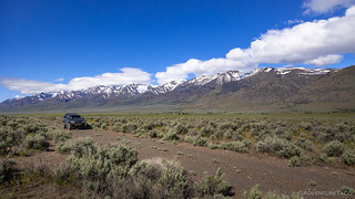
Luckily, we were able to make it around the drift, and upon reaching the rim of the valley, we were faced with 20 miles of Steens Mountain, gradually rising in front of us.
Hoping that would be the last of the white stuff to present itself along the trail for the day, a half-mile long spur that led to the edge of Steens Mountain - some 20 miles north of the Alvord Playa - was a place I'd considered to be a camp site when I'd first planned the trip. With a constant 40mph wind ripping over the ridge as we arrived, it was obvious that there'd be no camping - at least this trip - but we still worked out way out to the edge to admire the view.

In the distance, dust blowing across the Alvord Playa.

The other direction, our shelter from the wind!
Even with all we'd seen so far, it was still only 9:30am, but rather than feeling confident about the rest of the day, our brief encounter with snow had us on edge - especially since I hoped to reach the head of Kiger Gorge, at a mere 8,900'.
Hmm, right.
Anyway, I tried to push that elevation out of my mind as we rambled up and down along the plateau-like mountain-side. We were headed west now - across the Kiger Mountain Mustang Viewing Area - on our way to Diamond and the trailhead that would lead us to the mouth of the gorge. Or at least, we were headed west until we came to the Snow Mountain Cabin.

Looked like it could even be occupied.
This cabin is quite clearly still used on a regular basis, everything buttoned up with care and signage noting that occupancy was by reservation only. And of course, to make a reservation, you probably have to know the owner! I was careful to leave it just as nice as I found it, only snapping a few photos so that I could contact the owner and let them know the condition of their oasis atop the mountain.

It was not a warm day.

A hunting cabin, as evidenced by the racks, as well as the entries in the logbook.

I read a few of the stories of past visitors, and thought this was a great one. We all have days like this, but my sense is that these kids handled it better than most!
From the Snow Mountain Cabin we continued west through the wild mustang viewing area, our hopes high that we might see some wild mustangs roaming the hillside. Maybe because it was too early in the season, or just because the day happened to be on the cold side, we didn't run into any - though the lush green landscape helped to keep our spirits high.
Spring on gently sloping side of Steens Mountain.

Another cabin!

Small windows through massive rock walls that were more than two feet thick.
Well, despite nearly losing the trail in a couple of places, we eventually hit Happy Valley Road in Diamond and turned towards the unnamed road I'd routed to take us to the top of Kiger Gorge. Over on this side of Steens Mountain, what we thought initially to be blown dust was actually fog piling up against the ridge, making for an eerie sensation as we began our trek east.

Green under grey. If this pea soup didn't clear, we weren't going to have much of a view at Kiger Gorge!
Where we nearly lost the trail across the Kiger Mountain Mustang Viewing Area, it completely disappeared about three miles into our 27-mile climb through rolling pastures and thousands of cattle. With problems stacking up - the fog was only getting thicker, our bellies were grumbling for lunch, there was a 99.999% chance of getting stopped by snow (even if we were able to find a road) - we pulled over to solve the most pressing issue - with a liberal application of PB&J sandwiches and potato chips.
Then, we made the responsible decision to turn ourselves around and show ourselves back down the mountain. We'd been beaten - this time - by a long-forgotten route to Kiger Gorge.

Heading back off of Steens Mountain - if only for a moment.

Well hello, marmot!
With our attempt at Kiger Gorge squashed, we briefly contemplated running over to Diamond Craters to explore a bit and find camp - except that we quickly realized that with all the fog on this side of Steens Mountain, we weren't really going to see anything there. Of course, we had no idea of the conditions on the east side of Steens, but we figured we might as well head that direction and hope for the best!

Heading east along Little Kiger Creek.
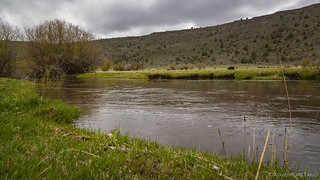
High water this time of year!
For a while, the road along Little Kiger Creek was fabulous. Like all of the roads over Steens Mountain, it was nearly 30 miles long, and I'd say that for the first five of those miles, it seemed like we'd made a great decision - only a few gates to be opened and closed as we progressed quickly up the gentle western slopes of the mountain. It was 2:30pm and I thought we might make it back to the Alvord Playa within an hour.
Except, with each gate we passed through, the road became less and less travelled. Eventually, the well-defined road became a two-track, and then - as we passed yet another old hunting cabin, a no-track, the entire road covered in 16-inch-tall grass, trees and shrubs encroaching from both sides.

Another surprise cabin.
Not frequently visited, but appears to be structurally sound.
Well then, could use a bit of work.
With the deteriorated roads - which I wouldn't run again myself, or suggest to anyone else - our progress slowed dramatically for the rest of the climb, but we pressed forward, knowing that at any time, we could run into a locked gate, forcing us to turn around, retracing our path to find another route.

Climbing up and out of Little Kiger Creek.
We probably ran into half-a-dozen gates over the next three hours. Luckily, none of them were locked, though several were so overgrown with sage that it was tough to pull back the barbed wire in order to get the Tacoma through.
Perhaps three miles from the end of the road, conditions slowly improved. It was a reassuring sign - one that gave us hope that we'd make it through. But then - as the road wound through a grove of aspen - we ran into the inevitable.

I hadn't even considered bringing the chainsaw, so we were lucky that the Japanese pull saw was enough to get these cleared.

I bet this is beautiful in the fall.
Finally, with less than a mile to go before we re-joined one of the roads we'd travelled earlier in the day - one that would lead us back down Stonehouse Canyon - we encountered our final cabin of the adventure. And it was a nice one!

A working cabin, with new fencing, a solid roof, and an interior that smelled of the countless fires that have kept its occupants comfy.

This cool old California license plate, and a small revolver were on the mantle. Plus, I always like seeing the brands of these ranches, though I couldn't find this one in the Oregon brand book.

An abandoned project? Weird.
With that - and with the cold foggy skies beginning to spit a little bit of snow - we made a beeline towards the trail that would shepherd us off of Steens Mountain and onto the Alvord Desert. We'd come up this way just 12 hours earlier to decidedly different conditions, and as the wind rushed through the canyon, blowing the snow continued to fall, we hoped that we'd be able to find suitable shelter for the night.

A cold, stormy evening as we descended Stonehouse Canyon.
Our plan was to camp at a little spot just north of the Alvord Playa, nestled into the trees and sheltered from the winds at the base of Pike Creek Canyon. We'd never camped there before, but on previous trips we've parked at the camp site and hiked up to the uranium mine, so we knew it'd be a good location - if someone else hadn't gotten to it first.
As we pulled up to the turn off of Fields-Denio Road, we noticed a steel cable across the road and looked at each other with surprise. In the last year or two - since we visited last - the BLM has closed the road (to vehicles) in order to protect the sensitive habitat. Well, dang!
And so, hoping that the 30mph winds would die down once the sun set, we headed for our usual spot - the playa itself.

It was windy out here, but at least we were out of the snow!
The Alvord Playa really is a special place, and with the truck pointed into the wind, we prepped dinner and climbed back into the truck - the tent not yet deployed - to read our Kindles and wait out the gusts as best we could.
At 9:00pm - having already fallen asleep several times - I couldn't wait any longer. I re-oriented the truck as best I could to ensure we wouldn't get folded up in our sleep, and within minutes we were brushing our teeth and climbing into bed. After two days of driving, with a blustery night of no sleep in-between, we were both exhausted.
Day 3...
Thankfully, around midnight, the wind did actually die down, and when I awoke the following morning, it was calm as could be. Having parked near to the edge of the playa to keep the blowing dust down, I now wanted a different perspective, so a few minutes before sunrise, @mrs.turbodb was transported a little more than a mile out onto the lake bed, the tent once again proving itself in 15-20mph winds.


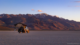
What a beautiful morning.
Leaving the camera setup to snap photos every 15 seconds, I headed back into the tent and enjoyed two more hours of sleep followed by another hour of reading as the sun warmed the tent and we had nowhere to be.
Eventually of course, we decided to get up, eat breakfast, and get on our way. Having run most of the roads - that we could anyway - the previous day, we decided to head home early after a little playing around on the playa.

Zoom zoom.
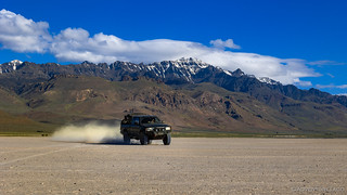
We weren't setting any land speed records in a 1st gen Tacoma!
Headed home; a little more snow on Steens than when we'd arrived the day before.
Usually when we're headed to - or from - a place, we do our best to make reasonably good time. Stopping only for gas, food, and bathroom breaks, our days are long and borning - podcasts, naps (for the passenger), and geology books, our sources of entertainment. But, a day ahead of schedule already, we made an exception on the way home, to check out an old car we've passed countless times in the middle of a field just north of Steens Mountain.

Watching time tick by.

Two hunks of metal, one of them fifty years older than the other.
And with that, we headed home. I have to say that I was a little bummed to not have made it to Kiger Gorge, but looking back on it now, it was another great trip with all sorts of unexpected discoveries. And of course, Kiger Gorge will be waiting, when we head that direction again!
More in this Area
")


Well well well, once again not on an actual road at times! Look at what you've become! 😉 Unbelievable! I enjoyed this story over a cup of coffee before work watching the morning sun through my window. Excellent story telling and photos! If that saw didnt work you'd have been winching that tree to the side! Way to keep the trails clear.
Looking forward to the next one!
Glad to hear you enjoyed the story! I suppose our first camp site was next-to, as opposed to "in" the road - no need to block traffic - but otherwise I don't know of anywhere that we were off the road. With everything I post, I'm pretty careful to stay planted on the trail - so many internet vultures out there looking for little infractions. ? Probably, the tall, green, spring grass is what makes it look like we're off-trail in some places, but I assure you that's not the case; though, we were the first through for the year on many of the trails this time! And for the tree - a tow strap or winch line certainly would have been my next tool of choice. The only choice with larger trees, as we found out the first time we tried to run Section 3 of the Oregon BDR back in 2017. That was a Mission Impossible, it turned out.
Another fine adventure, always enjoy your reporting and photos since most the places I will never be able to visit. I can sympathize with the blowing dust. We've had blowing sand here for weeks with 40+ mph winds. Winds (usually much stronger) we have every year but some guy plowed 40 acres just west of us and removed all the scrub that held down the sand so it all blew over this way covering driveway and vehicles. Only way to clear it is to blow it off and then sweep it up. Finally a few calm days without sand.
Thanks John! Speaking of blowing agricultural dust - we've seen quite a bit more of that recently than I feel like I've seen in the past. Perhaps it just coincides with trips we've been on and the wind conditions during those trips, but it sure seems to me that the dry weather in the west has been a big contributor the last several years. Glad you were able to get a few days respite to get it cleaned up. Can't be good for breathing, either.
the wind.....is a force
Another great trip on the Toyota, you did well as the Steen's can be brutal. Surprised not to see any cows ranging in the area. The wildflowers this year is spectacular, the late spring helped. Happy you all made it home safe.
blessings,
Kenny
Thanks Kenny! Have fun (and stay safe) out there when you test out the new wheels!
Great story. Loved the cabin log entry. Thanks for taking me and all of us along for the ride.
You're welcome! Nice to hear when folks enjoy the stories!
Is the ███████ road open to head up from the valley floor? Takes you right to that cabin with the new fence. Awesome trip report I've been itching to do this side of the Steens.
Unknown. We tried going that way off the mountain originally but ran into snow drifts across the road that were impassable. Also, ███████ is very populated at the bottom (at the ranch compound) so I'm not sure if they'd be open to people crossing through that portion of their (private) land. I think if I were to do it again, I'd probably drive up ███████ from Fields-Denio Rd, so I could ask permission to head up that direction.
Note: road name redacted, since I've not mentioned it previously in my story, and it's private land.
All good on the road name. Thank for the info. I figured i would try from bottom too and see if you can go through the ranches. Ive done the loop and and bunch of other areas around there but the north side of steens i didnt get to down across to alvord.
I'd still like to do more on the north side. I think there's a way into that area from OR-78 closer to Burns, where you can be "on the mountain" the entire time. Then, I'd like to find a route up to Kieger Gorge from the north (I know the loop goes by there, but I want something a little less developed). I'd also love to spend more time there and - hopefully - see some of the wild mustang herds that roam around.