
In all the years I've been exploring the deserts of southern California, I've never made it to Joshua Tree National Park. The reason - if a little lame - is also simple: it's just too far away.
Now, I know what you're thinking - they drive 20+ hours from Washington to Death Valley on a regular basis - and Joshua Tree is too far?
Yes. It's a few more hours, and even I have my limits for what are usually 5-day trips where we leave at 8:00am and need to get at least a few hours of sleep before starting the first of three days exploring before a maniacal drive home.
This time was different. Not only is the Tacoma - which lives in Las Vegas - less than three hours away by plane, but I'd just finished exploring the nearby Dale Mining District with a buddy. With four solid days in front of me - and a long list of places to explore - I figured that I could get a good introduction to this park that I'd only heard about from others.

I am so accustomed to Death Valley that it didn't seem at all strange - at this point - to enter Joshua Tree National Park on dirt roads and without seeing a pay station.
Not really knowing what to expect, I figured that since Joshua Tree was in the desert, it'd be a lot like Death Valley - low visitation, plenty of spots to "get away," that kind of thing. And, as I headed south - away from the heart of the park and towards a remote corner of Pinto Basin - that's exactly what I got.
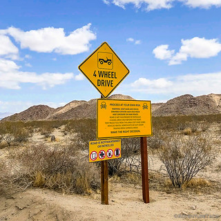
I guess the National Park Service (NPS) tries to scare most folks from heading this way. Fine by me!

Boy, this road sure is nicely graded. Must not see many visitors! 
I'd later find out that my introduction to this park was not at all normal, but for now - making my way east along Black Eagle Mine Road - I was looking forward to my first hike. It'd be a six-mile trek - trailless and across open desert - to find an Arrastra at the Lucky Turkey Mine, and an old cabin at the Blind Mule Placer Mine. Of course - as usual - I'm getting ahead of myself; first I needed to reach the trailhead.

Pinto Mountain, from the south, was a colorful backdrop as I sped east.

Skirting the park and the Eagle Mountain Mining District, I couldn't help but to marvel at the landscape unfolding before me.
Only about two-thirds of the 12-mile-long road was graded, and after bumping my way to the park boundary, things got a little interesting. Here, the road dove into a wash. Already lightly traveled, I wondered - as the last of the tire tracks faded away after a less than a quarter mile as soft sand in the wash got deeper - was I making a poor decision?
Pushing on, I followed the easiest path I could find - winding my way through boulder fields, following the route that the most recent rains had carved, and hoping that I'd pick up the road somewhere up ahead.
I never did, everyone else had turned around.

Making my way down the wash, a (dead) smoke tree looked so graceful against the blue sky.
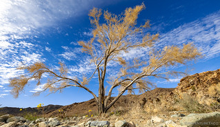
Another one. I think the wispiness of the trees and clouds was what got me.
New life with the old.
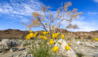
(Desert Poppies, Eschscholzia glyptosperma)

Beside smoke trees and poppies, I also spotted this guy eyeing me warily. It looks like a Desert Spiny Lizard, and those scales are very pointy!
Halfway down the wash - or at least, the section of it I was travelling - I hit the boundary between the Eagle Mountain Mining District and Joshua Tree National Park. Denoted only by a few fenceposts across the sandy wash, I found an out-of-the-way spot to park - as if anyone else would be coming along - and gathered up my camera gear. It was 3:15pm - less than two hours before sunset - and I had six miles and some picture-taking to go - I'd be cutting it close to get back before dusk!

The wash was wide and easy to hike, and while the hills weren't dramatic, I enjoyed the subtle color variations.
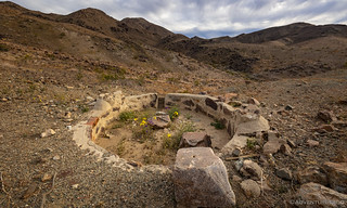
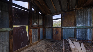
Pretty quickly after setting out - perhaps only a little over a quarter mile from the trailhead - I got my first treat. An old stone cabin stood guard on the side of the wash. Whoever built it - and for whatever reason - those details have been lost to time. Still, it's always fun to come upon an old structure like this.
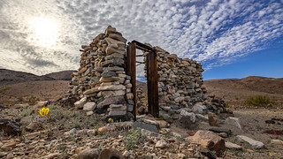
Wood-framed door.
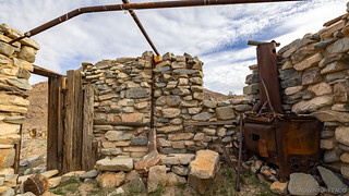
It was interesting to see how the metal frame was built into the cabin - note the vertical post - when the rockwork was constructed.
A bench on the shady north side.
I was really looking forward to the next waypoint on my journey. Not far away, it was an arrastra from the Lucky Turkey Gold Mine. Perhaps because arrastra aren't all that common, or because they are such a low-tech way to coax gold from the ground - or perhaps because I'm easily intrigued - I'd highlighted this hike as one that I didn't want to miss when I'd put together the Joshua Tree trip. Funny thing was, I had several arrastras marked on my GPS, so maybe they aren't as uncommon as I might have thought!
Heading down the wash - and then up into the nearby hills - there were plenty of reminders that spring was right around the corner. Or - I suppose - already here.
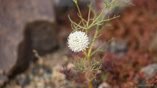
Fremont's Pincushion. (Chaenactis fremontii)
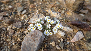
Desert Star. (Monoptilon bellioides)

Desert Sunflower. (Geraea canescens)
The Lucky Turkey arrastra was right where I expected to find it, and - like the hike - full of wildflowers! With a commanding view of the wash, it sat some 30 feet below the (now covered and sealed by NPS) vertical shaft from which ore was mined, its wooden drain gate and drag stones seemingly ready to be pressed into service at a moment's notice.
This is one of the cleaner arrangements I've seen - perhaps it was never used very much.

The drain gate looked to be in great shape.
I'd dawdled enough that as I picked my way down the hillside - following a few old miner's trails - from the Lucky Turkey, I'd already used up 45- of my 105-minutes before sunset. With five miles left to go, I needed a little less distraction and a little more move-on.
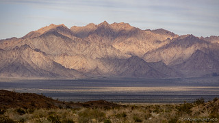
As I reached the mouth of the wash, the Coxcomb Mountains loomed in the distance.
After hitting the southern border of Pinto Basin, I followed the base of the Eagle Mountains to the left. This - I soon realized - was a lot like the hike that @mrs.turbodb and I had done to Military Canyon at the base of Death Valley's Owlshead Mountains: it was the direct route, but one that required a near constant up-and-down as I traversed wash after wash that cut through the alluvial fan.
In other words, pure torture. 
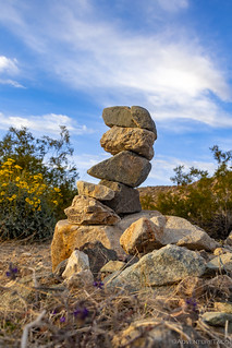
Apparently I was not the first to travel this trailless route, though I may have been the only in quite some time. This cairn has been here since at least 2008 when the dzrtgrls came this way and found it.
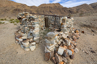
I reached the Blind Mule Placer Mine - or at least, the old cabin - only a few minutes before the sun fell below the horizon. Some might say I'd timed it perfectly - to capture the sunset, to take advantage of the warm light - but the reality was that I'd severely overestimated my ability to cover ground without stopping for photos. Seriously dude, will you ever learn? (No.)
Happy to be there, I figured that the walk back - even if it was partially in the dark - would be straight forward - so I set about enjoying myself. Live in the moment, you can always regret it later. Or not. 
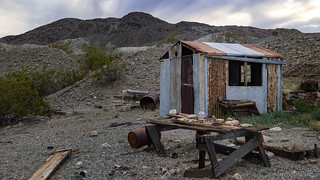
The little cabin was nestled onto a small shelf a few feet below the bottom of the wash. Probably kept the inhabitant out of the wind, but was certainly living "on the edge" should a heavy rain come through!
Not much left inside, except for the obligatory box spring.
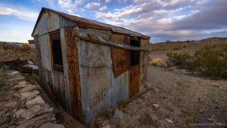
Everyone needs gutters.
Ultimately - cognizant of the time - I only poked around the little cabin for ten minutes or so, since there wasn't a lot to see. With the sky changing color, it was time for me to high-tail it back to the Tacoma, and figure out where I was going to stay for the evening.
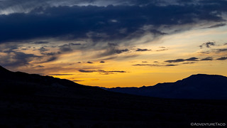
Orange and blue.

Purple delight over the Coxcomb Mountains.
I made great time hoofing it back to the Tacoma - covering the 2.5 miles in a little less than 40 minutes - only reinforcing the poor timing decisions I'd made earlier in the afternoon. Natural consequences be damned. In fact, there was even a bit of light left when I reached the truck, and I took full advantage - getting dinner prepped and cleaned up before a headlamp was required.

My first night in Joshua Tree was - by far - my most relaxing.
It'd been a full day - wrapping up one trip and starting right in on another - but one that I'd thoroughly enjoyed. Little did I know that my real introduction to Joshua Tree wouldn't come until the following day - when I'd come face to face with that which I'm always trying to escape.
And it wasn't trouble - I love trouble. It was something much less enjoyable.


I very much enjoy following your adventures. ?
Awesome, thanks Harold. It's nice to have you along! ?
The picture of the Coxcomb Mts. is beautiful. Looks like another 'Rear Locker' destination for me. I also like the dead tree pic's. I got a few of them in Lovell Canyon Last month. The wind changed and blew the still attached dead bark in the direction of the camera. One can only see these things if one gets out there, it's all happening. Cow Camp Rd. in the Wildlife Preserve is next. Happy Trails!....https://www.youtube.com/watch?v=INuhObJxAaQ
Thanks James! I didn't even realize those were the Coxcombs when I snapped that photo, but I was pleasantly surprised when I looked it up when I got home. Turns out that after exploring the "usual" bits of Joshua Tree, I made my way home via the other side of the Coxcombs, with a fun hike up their rocky escarpments to cap it off.
Have fun out there exploring Cow Camp Rd!
Great job on the flower I.D. ! (although the genus is properly capitalized the species should not be: ie: Chaenactis fremontii . You have properly put them in italics. No italics and underlined is also correct). And looked like another great adventure!!
Thanks, I'm trying to get more and more IDs into the stories because... well, I have a crazy family of botanists to live up to, hahaha! ?. I'll go through and update the capitalizations now, and I'll probably need check other stories as well - I'm sure I've gotten it wrong in them too.
Thanks for sharing, great photos.
I been there but never to the cabins. Can you provide the Google GPS Coordinates and also include the wash you were in? We're adventurous.
Thanks.
THANK YOU AGAIN....GREAT PHOTOS....ALMOST AS GOOD AS BEING THERE!!