

It took us longer to find a lunch spot than we expected, swarms of mosquitoes attacking us as soon as we ventured into the shade along the side of Currant Creek. While the pesky little buggers didn't seem to phase the deet-drenched RVers, we prefer almost anything else - wind, rain, and cold - over those damn blood suckers, and so we pushed on to higher ground before breaking out the sandwiches that @mrs.turbodb has prepped before leaving camp just before sunrise.

Our bellies no longer grumbling, we wound our way along well-graded forest service roads that ebbed and flowed through the tall trees and high mountain meadows. It was hot here at 8,000 feet - in the upper 80s °F - but the green grass and bright wildflowers suggested that this was a new phenomenon. Only days earlier, spring had not yet given way to summer.
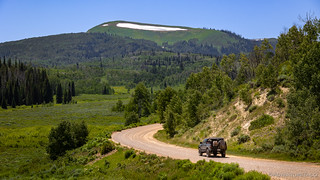


The driving here was nothing like we expected from a state that we generally associate with slickrock and desert mesas. Gone were the ruins and rock art, snow and rambling streams decorating the hillsides. Only the license plates of those tucked into the trees and nestled into shady nooks reminded us that this wasn't Wyoming or Colorado.
We continued to climb.

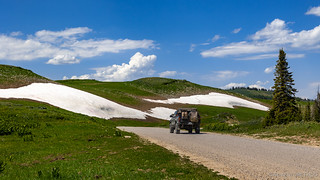
As we neared Soapstone Mountain we had a decision to make. It was 3:30pm and we'd covered about half the stage since lunch. While we could - likely, if we pushed into the evening - cover the remaining 70 miles or so before sunset, we knew that camping above 9,500 feet would be significantly more pleasant than baking in the oppressive heat at lower elevations near the end of the stage. Still, we figured that we'd take a slight detour - one that @mrs.turbodb had found - to the top of Soapstone Mountain, and then we'd find camp somewhere a bit further along the route as we climbed even higher through Bald Mountain Pass.
But of course, I'm getting ahead of myself.
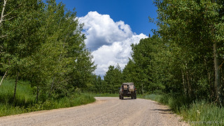
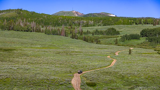
Unlike all the roads that had allowed us to cover half a stage in a quarter of a day, the road to Soapstone Mountain was slow going. Nothing difficult, it was simply narrow, uneven, a little bit muddy, and just technical enough to keep the weekend warriors from toting their trailers and hauling their UTVs the couple of miles to the top.

What we discovered at the top threw a wrench into our plans. It was way too early to stop for the day, but how could we not stop when we found a place - at the end of a road - where the generators, SxSs, and constant parade of RVs could not be heard?
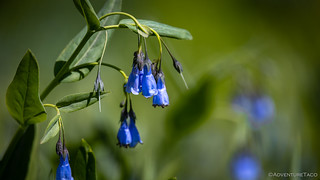
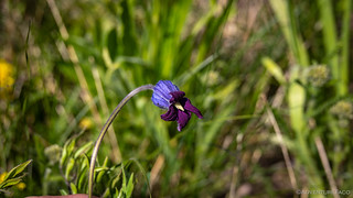
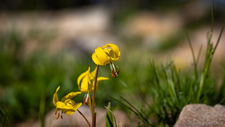
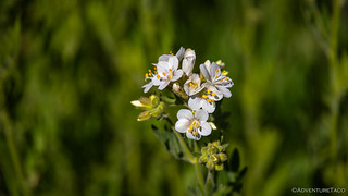
It was, we decided, time to slow down. It was time for a nap. And then dinner. And then sleeping. First though, we admired nature's garden that flourished around us.

Gathering up our Kindles and opening the tent as wide as could be - every screen called into action - we lay with a gentle breeze blowing through the doors, whisking away the heat of the afternoon sun. I read for a full five minutes before the weight of my eyelids was too much to resist; @mrs.turbodb only a little longer.
Ninety minutes before sunset seemed like a good time to make dinner, my alarm chiming gently a few minutes before that. Like us, the mosquitoes - thick here in the water-rich environment - were in search of nourishment, forcing us into the cab for a delicious pasta salad as we watched the clouds roll by.

Just as the sun set to the west, we climbed up the ladder for the final time. It'd been a lazy evening, completely out of the ordinary. And it'd been fantastic - a reminder that slowing down and enjoying those special places is worth so much more than speeding to the next destination.

The Following Morning...
My favorite sound when I'm sleeping in the CVT tent is the pitter patter of rain on the fly, especially when I know that the storm will pass in the night, a breeze moving it along and drying the tent by the time I need to put it away in the morning. It's also nice - in a slightly different way - to hear mosquitoes buzzing around while knowing that it's perfectly safe on "this side" of the netting.
It was midnight or later when I finally pulled the covers over my body, the refreshing breeze making for an even more pleasant sleep. And with no alarm, we didn't wake again until well after sunrise.

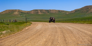
We - or at least, I - hadn't realized it the afternoon before, but a reasonably long stint of pavement began only a few miles further along the BDR. Winding through a high-mountain pass under the watchful eye of Bald Mountain, the place was buzzing with people, even at 7:30am in the morning.
Had we tried to find a spot to camp here, we most certainly would have been disappointed - but having enjoyed our own private peak, our spirits were high as we pulled into the Provo Falls parking area for breakfast.


Swatting mosquitoes as we shoveled cereal into our mouths, we hung around just long enough after eating for a few photos. In that time, five vehicles carrying 17 people cycled in and out of the parking area, each of them spending even less time than us, as they hurried along their way.
Soon enough, we did the same.

Here, we were travelling the Mirror Lake Scenic Byway - a stretch of pavement that reminded us of our time in the Snowy Mountains exactly a year earlier as we explored the Wyoming BDR. With high peaks - at 11,943 feet, Bald Mountain is one of the highest peaks in the western Uinta Mountains - and glassy lakes, there was much to admire, and we didn't hesitate to get out and look around.


Soon enough we were back on dirt for a short alternate section of the route designated as "expert." Certainly more technical than pavement, it was mostly just a bit bumpy, though an 18" deep water crossing might be more difficult for a dual-sport bike than for a four-wheeled machine. Regardless of the difficulty, the route was - once again - full of fantastic views - as we followed the meandering trail.


Now nearly through the Uintas, @mrs.turbodb raised an issue that she'd been thinking about - and frankly, mentioned a few times - since she'd gotten her first look at the route and each of the stages: for some reason, the Utah BDR was about to, not only enter Wyoming, but end (and then start) a stage there.
Certainly seems a bit fishy to me.
However, we'd have plenty of time to dwell on the question of whether we were running the final segment of the WYBDR when we actually got there; for now we had a few more miles of mountains to cover. Albeit, not as quickly as we expected.

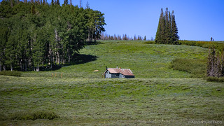
As we crested the final ridge, I spotted a wagon-looking-trailer-camp tucked away in an adjacent meadow. "A sheepherder's hut." I mentioned nonchalantly to my copilot, and something she didn't pay much attention to.
Until, that is, we were stopped in our tracks.


Driven by herders with the help of their dogs, we'd eventually discover that these tasty snacks were dropped off more than 30 miles - and 2,500 feet lower - than their preset position. No idea how long it took to drive them that far, but at least there's plenty of meat for dinner. We proceeded cautiously.
We didn't get dinner, but it was certainly an experience being in the middle of a herd that size, and though I joke, I was glad to get through without running over a lamb or starting a stampede into the Tacoma. Certainly the herders seemed glad that we proceeded so slowly through their flock.
Now picking up speed, we lost elevation quickly as we dropped down through the Thousand Peaks Ranch, sheep shit whizzing up onto the wheel wells as I tried to avoid the worst of it. Still, we were lucky, not everyone riding the road today had wheel wells to catch the crap.

A few minutes later, we entered Wyoming. The roads here were wider, and we couldn't quite put our finger on what was different... until we could.

Evanston, the end of the stage - and the spot where we were fixing to have lunch after suffering through all those tasty kabobs and chops and meatballs that had teased us on the road - was only ten miles away and with wide roads giving way to pavement, we covered that ground quickly.

After filling up with fuel and popping into the local grocer for a few supplies we'd exhausted over the first five days, we found some grassy shade near the high school and pulled out the camp chairs. As I munched on Fritos, @mrs.turbodb assembled turkey-and-salami sandwiches and we pondered the final leg of our journey!
The Whole Story


")


Love Backcountry Discovery Routes? Check out
BDRs we've run
to find your favorite.


")
")
")


")
")
Another fine post, but
"Where there are people, it seems there are crows"! Those are certainly Ravens (Corvus corax), a superior corvid, who tend to be in pairs, not flocks, and much more often than crows to be in wild country. Note the very heavy bills, and the shaggy neck, especially on the bird on the left.
Ahh! Thanks for the proper identification, Anthony. Up in my neck of the woods (Seattle area) we have mostly crows (I think) and so I associate all "black birds of that type" with crows, but I am definitely familiar with the - usually also larger, if I recall correctly - ravens as well. I like your identification mechanism - travelling in pairs and in wild country - those will help me towards correct identifications in the future! ?
Yep, what I was thinking. Out here we have lots of ravens, usually in pairs, big ones always looking for a squirrel or other road kill for a snack.
Amazing that you saw only one motorcyclist on the entire UTBDR. Maybe the heat kept them away?
We were surprised as well. Could definitely have been the heat - which had to be a bear in all the motorcycle gear. Or, it could have just been luck of the draw - plenty of places on pavement or when getting fuel to pass without really noticing each other, I suppose. And, of course, there are "alternate" sections/routes to the main one (generally for more advanced riders), so they could have been on a main route as we took an alternate.
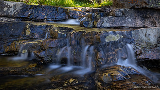
Another fine trip through God's country sprinkled with colorful flowers to calm the soul. I love the contrast of the stream of frozen water and the soft effects of the ND filter slowing the water to look like cotton candy.
Oh yes, the DP bike adventures, my buddy and I have traveled many miles on our DP bikes in the past. Loved the Salmon River area in the mountains.
Blessings!
Thanks Kenny! The ND filter was a Christmas present, and I haven't had a chance to use it much yet, so it was fun to try out on these falls.
The area in and around the Salmon had to be a lot of fun on bikes. I've only ever had a street bike (I rode a CBR600F2 for about 20 years), but I'd love to get something that will go on dirt once the kiddo is out of the house.
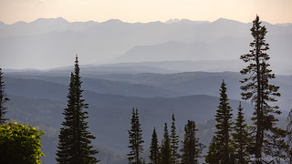
Another fine adventure and beautiful photos. The photos of green valleys/meadows and clear blue lakes reminds me of our backpacking trips in the Sierras, I really miss that long hikes. Out here in the desert we don't see much green but we do see sheep! Yep, herders and their large flocks and a dog or two to keep the critters in line. Main difference here is that herders are on foot not horseback. Even if you don't see a flock you'll see where they crossed the road with plenty of sheep dung marking the crossing.
Yes, we were thinking of the Sierra as we were at elevation in Utah. Actually, also reminded us of some of the elevation we got in Wyoming on that BDR as well. Such a nice relief to get into the green after the hot temps down lower (in southern Utah).
Haven't gotten into the Sierra yet this summer, but I've got a trip coming up to a favorite spot. You'll recognize the one when you see it.