

Having wrapped up our brief time in town with a quick meal and a refreshingly cold Coke - kept icy cold in my favorite stainless steel vacuum cup - and chocolate frosty from Wendy's - it was time to find some respite from the heat. A hotel room - with a shower - for instance.

Alas, there was no hotel room in our future, though we have been known to take a shower in the middle of a hot - or what we thought was hot at the time but was only in the mid-80s °F - Backcountry Discovery Route through Idaho. Being only the second day of our trip however, our "we smell like human," meter wasn't yet ticking off the chart, so it was straight to camp for us.

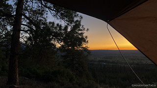
We passed through - or rather, by - the town of La Sal as we climbed into the foothills surrounding the La Sal Mountains, the sun sinking to our west. In the 45 minutes or so since we'd left Moab, we'd found a couple promising looking spots on the tablet that weren't too far off our route but were far enough from the highway to minimize any noise that might hamper our beauty sleep.

Nestled between the trees, and on a road that clearly doesn't see many visitors, we took a few minutes to wash our faces and enjoy the pastel sky before climbing up the ladder and onto our bedding. Even at 8,052 feet it wasn't exactly cool, but the 75°F temps sure felt fantastic after a long day in the sun.
I'm not sure how long @mrs.turbodb lasted, but I don't know that I even turned a single page on my Kindle before my eyelids closed and I was out for the count.
The following morning...
Though we planned to be at higher elevations - at least, for a few hours - we still wanted to get an early start to our day in the La Sal Mountains. We'd heard through the BDR grapevine that a couple of riders had run into snow along this section of route just a couple days earlier and figured that we'd be glad for a couple extra hours if we had to re-route in a significant way.

We rolled out of camp just after 6:30am, the landscape dramatically different than the red rock we'd encountered the previous day. As we continued to climb through the foothills of the La Sals, green grass and wildflowers were the name of the game.
Oh, and cows. So. Many. Cows.
I don't really mind cows. Frankly, I enjoy berating them through the windshield, and honking at the young ones that are not used to vehicles. "Dumb cows," I'll exclaim for no other reason than it makes me feel good.
I do mind all the cow shit on the road, however. Running over it sucks once because it gets all over the truck; twice (or more) when getting out of the truck to take pictures and having to smell it all over the undercarriage; and a third time when I wash the truck and the pressure washer blasts the wet-again cow shit back into my face.

The cows always seem to get the last moo. Or at least, their shit does.
Anyway, trying my darndest to avoid the liquid cow shit on the road, we continued to climb, the views getting better and better as the temperatures got milder and milder. It was fantastic!


Despite my ranting about cows - not the last of this trip, mind you - this really was a splendid section of trail. Spring was in full-force up here, and we stopped several times on our way towards Geyser Pass to revel in the colorful surroundings.

(Painted Lady - Vanessa cardui)


Climbing through 9,500 feet, the scrub oak and meadows gave way to some of the largest groves of Aspen that we've ever encountered. As beautiful as this place was - sunlight filtering through fluttering leaves - it must be truly spectacular come fall. A reason to return, for sure!


And then - as we suspected - snow. We'd hoped out loud that the warm temperatures of the last several days would have melted it, and I'm sure that it was melting faster than normal, but when there's this much of the white stuff and the road shrouded in shade most of the day, it's going to take more than a couple of days to make a meaningful impact.


Ultimately several smaller drifts gave way to one more than three feet deep that covered the entire road. With no existing tracks, we probably could have shoveled our way through in an hour or so, but as swarms of mosquitoes descended on our sleeveless appendages, we quickly concluded that - for us at least - this route was impassable. It was time to find another way 'round.
Taking another look at our maps, we determined there to be three choices:
- A couple miles back from our current position - and at 600 feet lower elevation - a series of roads peeled off to the east, eventually working their way back to Geyser Pass.
- Nearly back to the highway - UT-46 - the main road split. Our fork, to Geyser Pass, was clearly the primary route, but La Sal Pass Road would also take us up and over the mountains, albeit at significantly higher elevations.
- We could tuck tail and run a third option for stage 2 of the BDR - one we hadn't even considered in our planning - the "winter bypass."
While the smart money would have been on the winter route - a little ironic given the triple digit temperatures we'd been fighting - we're glutton for punishment and so opted to give the shortest reroute a try first.
Diving off Geyser Pass Road near Dark Canyon Lake, we failed quickly. Though much of the land here was public, a few private chunks were sprinkled throughout, locked gates blocking our passage.

With no other choice, we headed back the way we'd come - retracing nearly all of the 19 miles and 3,000 vertical feet that we'd climbed in the previous couple of hours. We ran into a group of dual sport riders - three weeks into riding the TransAmerica Trail - and gave them the low-down on the situation, letting them know that our heavy beast wasn't going to make it through, but that they might be able to walk their bikes over the white stuff if they got as much weight off as possible.
We never saw them again, so maybe they made it!
At any rate, we'd nearly resigned ourselves to taking option 3 - the "winter bypass" - but as we neared the turn to La Sal Pass Road, we took one more look at the map and decided that it was worth a shot, even if it was a long one. After all, we were on and adventure. Oh, and if it worked, we'd keep ourselves in the higher elevations longer - something we were definitely keen on doing!

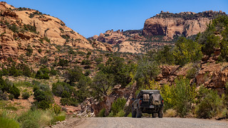
As had been the case on Geyser Pass, it was absolutely stunning to see the transformation from early summer to full-on-spring as we gained elevation. We'd reach just over 10,700 feet as we crested La Sal pass, our surroundings idyllic, and each of us questioning why the BDR route didn't utilize this trail. Even better, by following all the right undulations, the road remained in the sun nearly the entire time, its surface dry as a bone. Even 600 feet higher, it was smooth sailing!
Well, not smooth sailing - the bumpy, rutted descent on the west side of the pass was a little worse for wear, especially compared to the well-graded Geyser Pass Road - but that was just fine with us as we enjoyed the colors and temperatures at these higher elevations.


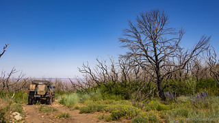
We'd later discover that La Sal Pass was the original route of the UTBDR, likely changed when the Pack Creek Fire passed through the region in 2021. Charred trunks still covered the hillside as we picked our way down through Dorry Canyon and Brumley Creek, the road - perhaps last used for fighting the fire - getting sketchier and sketchier.

Eventually, after one rather sketch-tastic off-camber section that I failed to snap a photo of, but insisted that @mrs.turbodb exit the cab as I crossed, we linked back up with Geyser Pass Road for the final descent back into Moab.


As we glanced at the clock, it happened to be lunch time. Convenient given that we were once again at 4,350 feet and it was hot! We found a tasty little taco truck - Tey's - and proceeded to order a few breakfast tacos and a carne asada burrito. Both were delicious, consumed ravenously as we reveled in the string of water misters that'd been strung across the canopy under which we sat. Naturally, we forgot any sort of photo, but we'll certainly be returning any time we're in town!
Having consumed two meals in the same town - and on the same trip - we were feeling a bit like the dual sport riders for which the BDRs are technically created. Those guys can't carry as much as we can - and certainly can't lug along a Dometic fridge - so stops in town for fuel and sustenance are required. It was pretty nice, all things considered!
But we couldn't postpone the inevitable and soon enough we were back on the route, heading into the Sand Flats Recreation Area just east of town.
I don't know if it has always been the case, but this is the first time I can recall a BDR taking a toll road, the BLM entrance station charging $5.00/day per vehicle. Well worth it, I suppose, for all the folks who come here for some of the most well-known trails in Moab.
And of course, we figured - while we're here, we might as well give one of them a try. So, throwing the BDR track to the wind, we peeled off the well-graded main road, and hit the slickrock surface of Fins 'n Things.


A fun little trail, I could see why folks flock to this place. Still, it was a little more commercialized than we prefer, so after speeding through, we were happy to get back onto the main route - into the northern La Sals - and away from the omnipresent crowds.
Our ultimate destination was Dewey Bridge via Onion Creek and soon we found ourselves retracing a route that I'd run in the opposite direction on The De-Tour - my very first adventure with Monte @Blackdawg and Mike @Digiratus as we attempted to escape the rain and snow of Montana. Though the rain had followed us south along the route we'd chosen to take - the Kokopelli Trail - Onion Creek left an everlasting impression on my mind, and I couldn't wait to show it off to @mrs.turbodb!
Of course, first we had to get there.


I must have told my companion a half dozen times that I recognized this turn or that, and as we followed a sharp bend in the route, I had this strange sensation that going the opposite direction - for less than a mile - might be worthwhile.


It was nearly 5:00pm as we started our descent into Onion Creek. With a route that runs mostly east-west, we were in the unfortunate situation of driving directly into the sun. That, combined with the fact that I think it's better to run Onion Creek uphill, meant that the experience wasn't quite as breathtaking as I'd made it out to be in my descriptions. Still, as we worked our way down the canyon, there were certainly highlights worth enjoying.


With no traffic to speak of and the sun in our face, we reached the bottom in a little more than half an hour, popping out onto UT-128 for the last few miles of the stage. This stretch of highway - hugging the bank of the Colorado River - is one of the most dramatic roads I've driven. It's fabulous in both directions, the towering walls and postcard quality views, never ceasing to amaze.


Just before 6:00pm, we reached Dewey Bridge and the end of the stage. Built in 1916 - and the only crossing of the Colorado in the area until 1986 - Dewey Bridge was destroyed by a 7-year old boy in April 2008. Camping with his parents about a quarter-mile away, he wandered away from camp and started a brush fire with matches. At the time, the bridge was the second-longest west of the Mississippi; only the Golden Gate was longer.


With Stage 2 in the books, temperatures in the mid-90s °F, and no nearby elevation to speak of, we contemplated what our next steps should be. We briefly entertained the idea of tucking tail and heading back into the La Sals, but calmer heads prevailed and we decided to tough out the heat a few hundred feet higher, where the route would be overlooking Dome Plateau.
But that is another story...
The Whole Story


")


Love Backcountry Discovery Routes? Check out
BDRs we've run
to find your favorite.


")
")
")


")
")
As I expected, am really enjoying this UT BDR series. And the photography continues to dazzle!
I had read about Dewey Bridge several times in the past. It's a shame it was never rebuilt. Not for utilitarian purposes, but for historic ones, and it could have been converted to a foot bridge. I wonder where the road on the other side continues on to?
Glad you're enjoying it, as always!
As far as "the other side" goes (to the north), it just reconnects to the highway on the other side of the Colorado River. The road on the south - eventually - leads to Top of the World (amongst other places).
Thanks for sharing another interesting adventure and beautiful photos. Can't wait to get out into the open spaces when the weather cools a little.
You're always welcome John! It's definitely been a hot summer (compared to the last several). Makes adventuring hard, but our tomatoes are doing great, hahaha! ???
Yes, I gave up on tomatoes, felt like all I was doing is feeding the bugs! BUT, our 3 jujube trees love the heat and also the cold in the winter and produce very well each year. Green onions also do very well in the shade of the trees.