")

Of all the stages on the Utah BDR, I was most looking forward to the expert route through Lockhart Basin. This stretch of road piqued my interest for a couple reasons: first, it skirts along the edge of Canyonlands National Park, an area that never ceases to amaze me, no matter which district I happen to be visiting at any given time. Second, it was a segment of the M~U~D trip that Monte @Blackdawg and Mike @Digiratus ran back in 2016, and - even though I didn't know either one of them at the time - I'd been captivated by the views they'd shared in their trip report.
We'd be running it in the opposite direction, and surely the trail would be a bit different some seven years later, but as we approached Canyonlands from Monticello, there was no denying that we were in for a treat.

Every time I've driven through Monticello, or into the Needles District, I've seen the signs for Newspaper Rock. Yet, it's always been after midnight on the tail end of a 20-hour drive, and I've been significantly more interested in finding somewhere to close my eyes than checking out some petroglyphs in the dark.
This time, however, was finally different! It was just before 9:00am, we just enjoyed our breakfast with a view, and we had the place almost to ourselves.


It was - as mainstream panels go - a nice one. Lots of recognizable images, spectacular contrast between the patina and figures, and relatively little vandalism over the years. Still, while this should most definitely be a pit stop, I urge anyone who is into rock art to venture a little further off the beaten path. There is so much better stuff out there, and all you need to do is look!
For us, it was back into the truck - already with the air conditioning running - for the 10-mile approach to Canyonlands along UT-211.


Even if it looked well-graded and smooth, I was excited as we turned off onto Lockhart Basin Road. I stopped a few times for photos - as the green valley gave way to red sandstone - a distant mesa getting closer by the minute.


From this point on, I think it's safe to say that the road got progressively trickier for the next 70 miles or so, until we eventually reached the northern end of the road where it forks off to Chicken Corners and the Colorado River. That was (mostly) just fine by me, though there were a couple places where I had to get out and scout a line, and by the end we were both ready for something a little higher speed. For now, though, we enjoyed the views.

One of the nice things about having a copilot on a trip like this is that as I'm concentrating on driving - and being distracted by constantly hopping out of the truck for photos - she likes to pan around on the map for interesting information that I may have missed in my route planning. It was exactly that in-the-field investigation that uncovered an arch just a few miles down a spur to our west. Only a little after 10:00am, it seemed like just the kind of thing we ought to check out.


From Pelican Arch, we continued generally north, the road hugging the base of the cliffs; fingers left to slowly erode by the mighty Colorado River.


Half-an-hour later, we came to a sign that I recognized from my brief perusal of the official movie of the UTBDR. It was one that - not really knowing the geography of this area - I'd expected to run into at the beginning of the trail. One that promised our first views of the river.


We made pretty good time as we headed down Lockhart Canyon, the temperature rising as our elevation dropped. Winding our way through towering walls, Cottonwood trees began to pop up here and there as we got closer to the river. A good place for lunch, we mused, though in the end we decided to push on in favor of getting a few more miles behind us before stopping to rest.


Ultimately - though there was a bit of excitement as a bighorn sheep galloped away from our squeaky steed, I'm not sure I'd recommend the 12-mile roundtrip through Lockhart Canyon. While the scenery was spectacular, it wasn't any different than what we were already experiencing in Lockhart Basin, and there was no good access to the Colorado River once we reached the bottom - not that we were planning to take a swim or anything.
Making our way back to the main trail, two things were on our minds:
- Lunch.
- Wondering how we were going to keep from dying in the heat when we stopped for lunch.
With no Cottonwood trees to provide shade, we began scouting the shadows of various rock outcroppings and canyon walls for enough room to set up our chairs. Unfortunately, shadows were few and far between at 12:30pm and it took a few miles for us to find something suitable.


Forty-five minutes later, I noticed a perfectly positioned outcropping that provided just enough shade to keep us from melting. Pointing the cab of the truck away from the sun, we left the engine running and the A/C on full blast as @mrs.turbodb rushed to assemble the turkey sandwiches - with In-n-Out peppers - that have become our favorite sustenance over the last several months.
It was our quickest lunch of the trip - from stop to start, not more than 20 minutes - so eager were we to get back into the mid-80s °F that our air conditioning struggled to provide.


Back on the trail, things were starting to get a little interesting as we found ourselves no longer meandering slowly along a bumpy road, but rather picking a line through several boulder fields. These are sections that I'm sure have always been rough, but that haven't gotten any better with what I'm sure has been increased in the last couple of years. Many of these areas sported bypasses, something we were having none of, as I got out here and there to make sure that I knew the proper line before proceeding.


For two more hours we carried on along the base of the cliffs. I'm not sure how, but @mrs.turbodb managed to sneak in her after-lunch nap as the truck jostled and bounced its way along the rocky terrain. Once distant views grew nearer. The La Sal Mountains peeked out of the haze. And all the time, we were surrounded by glorious formations.


The final section of trail was perhaps the sketchiest. Following a steep drainage, recliner-sized-rocks and three-foot-tall ledges were the name of the game. I turned to @mrs.turbodb and mentioned how glad I was that we were going downhill rather than up, "I'm not sure we'd have made it the other direction," as I hopped out of the truck to inspect the lines and snap a few photos.
I'm sure that instilled all sorts of confidence.

Ultimately - or perhaps obviously given the existence of this story - we made it to the bottom of the drainage without an issue, the Tacoma flexing in all the right ways, the tires gripping in all the right places. I was sweating, @mrs.turbodb had her hands on the oh-shit-handles, and we were both ready for something a little less exciting.
And some elevation. Mostly we wanted to gain some elevation.
Elevation wasn't in the cards - at least not immediately - but it did turn out that we were at the northern end of the technical section of Lockhart Basin Road. Marked by a trail sign to Chicken Corners - something we had no desire to explore - the rest of the route along the Colorado River and into Moab was nicely graded and significantly smoother.


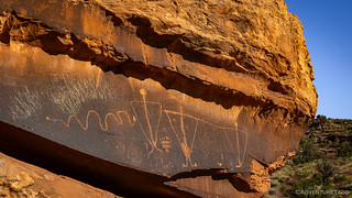
Only a few miles before crossing over to pavement, a marker for the Birthing Stone caught our attention. Reasonably near Moab, this site that was defaced in 2021, though the BLM has since removed the graffiti. Having recently visited the Birthing Cave in Mojave National Preserve, our curiosity was high as we pulled over to the side of the road to see how this site would relate to that one.
Almost all, if not all, of the rock art on Moab’s Birthing Rock was made by the Basketmaker people of the northeastern Colorado Plateau. The presence of Basketmaker rock art on most of the Plateau indicates that this culture lived in the region for almost 2,000 years, c. 1,000 BC to 1,000 AD. Major cultural shifts occurred around 300-500 AD and the Anasazi transition in the San Juan Basin around 800 AD. The quantity of rock art indicates that the largest populations of Basketmakers were found around Moab in the north, along the San Juan River drainages in the central region, and along the Little Colorado and Puerco River basins in the south and southwest. Each area’s bands used idiosyncratically local rock art designs, but there are many other designs and design elements that were similar and used across the entire region to express identical concepts and intent. This suggests social intercourse and cultural overlap between and among the different bands of the tribe over a wide area for a long time.The Birthing Rock: An Analysis
For an in-depth analysis of the Birthing Stone, check out this archived essay which analyzes each glyph individually and in the context of other rock art sites in the area.

(For more on the Moab Vagina, see the essay above.)


The Birthing Stone behind us, it was nearing 5:00pm, and it was hot. We'd managed to complete stage 2's alternate route, but the technical terrain had consumed nearly the entirety of a day.
To make our lives just a little easier, we headed into Moab to top off the gas tank, pick up a few things at the grocery store, and grab a bite to eat - at Wendy's - before deciding where we were going to search for camp.

The key - as had been the case the previous evening - was going to be finding some elevation. We hoped that wouldn't prove too difficult, though we knew that we'd have to contend with all the other folks who'd flocked to Moab as well. Hopefully they'd stay close to town, in their air-conditioned RVs.
Not that we'd have minded an air-conditioned RV ourselves. Perhaps with a shower. 
The Whole Story


Love Backcountry Discovery Routes? Check out
BDRs we've run
to find your favorite.


")
")
")


")
")
Some great views and interesting terrain on another amazing adventure. Things we would never be able to see without you sharing them. Thanks very much for sharing! BTW - the tent is sold and waiting for it to be picked up in about an hour. Money can go for a few more fixit things on the truck.
Thanks as always John, glad you enjoyed the story and photos.
And great news on the tent! Glad you were able to unload that and get a bit of money for it. Always nice to be able to take care of a few things on the truck. I've got a bit to do today as well - taking off some old shock mounts that I don't use anymore, sending them off to a buddy who will be able to put them to better use!