

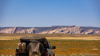
Pulling away from Dewey Bridge a little after 6:30pm, we'd already been on the road for 12 hours and we were spent. Unfortunately - as long as we wanted to continuing making forward progress on the route - there was no real elevation to be found until the beginning of the following stage, and we knew there was no way we could make it that far, even if we drove long into the darkness.
So, we resolved to keep an eye out for any location that sported a view and offered exposure to any breeze that might be present. Ideally, it wouldn't be more than an hour or so, so we could take a quick nap before enjoying sunset as we ate a cold pasta salad dinner that we'd prepared before we left home.


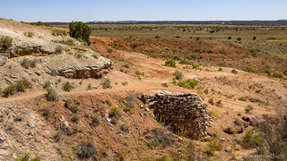
After poking around the cabins a bit - I'd visited them several years earlier, but if pressed I would have suggested that they were in an entirely different location  - we continued our search for an acceptable camp site. The trail now climbing slightly towards Dome Plateau, I mentioned to @mrs.turbodb that if we continued for another 90 minutes - off the BDR route - we'd run into the most epic camp site I've ever experienced. Not that either of us wanted to spend that much more time in the Tacoma...
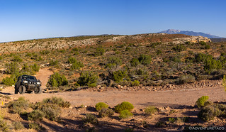


Then, as we traversed a cliff line to the north of Dome Plateau, a short spur led out to the edge. I'm always a fan of camping on the edge - the closer the better - and I don't think it surprised my copilot in the least when I suggested that we'd found our home for the evening.
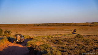
A rock or two leveled the Tacoma, and five minutes later we had the tent deployed and our Kindles in hand. With two hours until sunset, we had a little more than an hour of relaxation before pulling out dinner and enjoying it from our vantage point on the cliff's edge.

A few minutes before sunset we wrapped up our evening preparations - face washing, teeth brushing, and gathering of fresh clothes for the following morning - and climbed into the tent. With only screens for across the tent windows and doors, the warm breeze felt fantastic as we lay atop our bedding.
I'm not sure how long I read, but it was still light as my eyes shut, sleep coming quickly.
The following morning...


Our camp site at the lowest elevation so far - a mere 4991 feet - there was no dilly dallying around as we packed up camp. Still, though we climbed into the Tacoma only 15 minutes after the fiery ball crested the horizon, we were already sweating!
Our day started out by crossing the Yellow Cat and Poison Strip areas. Carnotite (Uranium) mining in the district began in the early 1900’s with one of the earliest claims being the Telluride mines. Filed in 1911, the Vanadium Ores Mining and Milling Company worked these mines through the mid-20s even as additional claims were filed in 1915 by the Pittsburgh Radium Company for the Pittsburg, Memphis, and Mollie Hogans mines.
Large scale Uranium mining began in the 1940's and took off in the mid-1950s. By the early 1960's, however, the demand for Uranium dwindled as the market had been oversupplied.
Driving through the Poison Strip, a small area cordoned off with barbed wire caught our attention. Wondering if there was an old vertical shaft, I popped out of the truck for a closer look and was immediately greeted by the most awful smell - and that's saying something given that after several days of heat, it already smelled pretty human in the Tacoma!


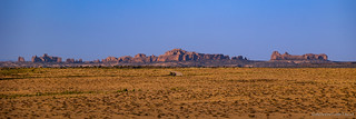
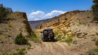
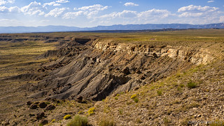
Continuing to work our way west and north, we rose and fell over hilly badlands of tan and gray Mancos shale - the deposits of a sea that once covered the western interior of North America. To our south, distant views of Arches National Park dotted the skyline as the road eventually crossed I-70 and headed towards the Book Cliffs.


I was really looking forward to the Book Cliffs. Not for any specific reason - I had no hikes planned, and only a couple points marked as interesting stops - but likely because I'd read trips reports from others, the details slipping easily out of my aging mind.
Still, driving through a series of canyons, and onto Sagers Bench, we were smack in the middle of all sorts of geology, and @mrs.turbodb was quick to relate the details as she read from the Roadside Geology of Utah.


Our time in the Book Cliffs would last until lunch - largely because the road wound its way along the undulating folds; 30 miles as the crow flies quickly turning into 60 miles of trail. It's a section of trail that one might consider skipping - a beeline to Green River affording an opportunity to refuel vehicles and relax in the shade of a downtown park. But doing so would mean skipping Sego Canyon - a worthy destination full of history - and there was no way we were passing this one by.
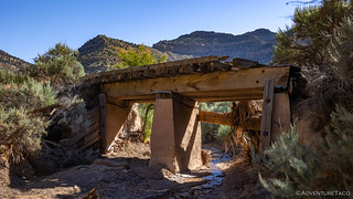
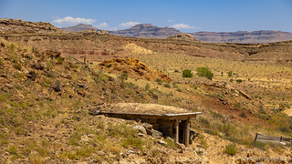
Our first stop was at the Sego ghost town. Inhabited between 1910 and the mid-1950s, it was a coal town; the bridges we encountered, part of the Ballard & Thompson Railroad - a spur from the Denver and Rio Grande Western - built by the founders of the town to transport the coal.
At the height of coal production, from 1920 to 1947, 800 tons of coal were being mined per day, with the train making as many as nine round-trips a month to the town.
The town's most serious problem - almost from the beginning - was a diminishing water supply. The water table was dropping, the creeks and springs drying up. By 1947 production costs exceeded income, and the company decided to close down. The miners that once had numbered 125 had been reduced to just 27.


After wandering around a bit - or really, wandering for @mrs.turbodb and hiding in the shade of some Cottonwood trees for me - we headed towards the main attraction, for us, of Sego Canyon - the rock art. As usual though, we were distracted within minutes, the old Sego Cemetery just off the side of the road as we headed west.
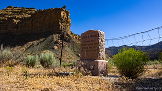

With most of the headstones blank - a testament to the harsh conditions that still exist here in Sego Canyon - there wasn't much to really see at the cemetery, so after a few minutes we were back on our way to one of the coolest rock art sites we'd see on the entire BDR.

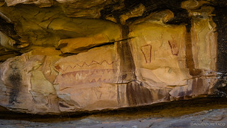


And then we really got into the thick of it. One of the things that makes the rock art of Sego Canyon special is that it contains several distinctive styles that are attributed to different people and time periods. The oldest art belongs to the Archaic period and dates to between 6,000 BC and 2,000 BC. Nomads, the Archaic were hunters and did not build permanent habitation structures, living in caves and in small brush shelters built out in the open. Near the end of this time period the Barrier Canyon Style emerged, characterized by large human-like (anthropomorphic) forms, some as tall as nine feet. Often with vacant looking or missing eyes, the frequent absence of arms and legs, and the presence of vertical body markings, they are sometimes seen with antennae, earrings, and with snakes in their hands. The ghost-like images are some of the most unusual and always a special find.

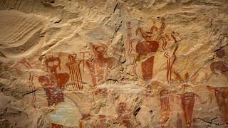

It was around 600 AD - and until 1250 AD - that the Fremont culture thrived in the region. Part-time farmers, they lived in scattered semi-sedentary farmsteads and small villages, never entirely giving up traditional hunting and gathering for more risky full-time farming. They made pottery, built houses and food storage facilities, and raised corn. Their petroglyphs also depicted unusual figures and were characterized by sharp edges, square or rectangular heads and triangular bodies.


Between 1300 - 1880 AD, the Ute people lived in Sego Canyon and they too added art to the sandstone cliffs. Prior to the arrival of Mexican settlers, the Utes occupied significant portions of what are today eastern Utah, western Colorado, and parts of New Mexico and Wyoming. Though never a unified group, they consisted of numerous nomadic bands that maintained close associations with their nearby neighbors, until they were forced onto reservations in the 1880s.

Energized by our latest discovery - so much so in the case of my copilot that she promptly took a nap for the second half of our drive through the Book Cliffs - we made our way to Green River for a relaxing lunch in the shade of a downtown park. It was 11:30am as we enjoyed turkey sandwiches and fresh cherries and discussed the plan for the rest of the day.
Spoiler: we were driving the Utah BDR.

I must say, we didn't really know what to expect between Green River and the end of the stage - not that we were in any way close - in Wellington. To our (admittedly untrained) eyes it seemed to skirt the around one of the most wonderful places in Utah - the San Rafael Swell - as it picked its way north, perhaps due to the fact that one could lose themselves in the fabulous uplift for weeks, never actually completing the route!

This portion of the trail - winding up Cottonwood Wash between Mexican Mountain and the Book Cliffs - followed the Old Spanish Trail and several information signs placed - seemingly in the middle of nowhere - by the BLM afforded us a bit of history as we passed through.
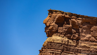
Skirting around the northern edge of the Swell, we could see Chimney Rock from quite a distance. With no idea whether we'd pass it or not, I probably took ten photos at various points along the way, just to be sure I didn't miss one of the most obvious landmarks in an otherwise relatively monotonous terrain.

Now headed west, it was clear that large portions of the trail were built on an old rail grade. With cuts through hillsides and built-up sections across washes, a lot of work went into what we'd later find to be the Spirit Railroad extension of the same company that we'd seen earlier in the day as we'd visited Sego Canyon.
In 1881 the D&RGW railroad company decided to extend their line through the San Rafael Swell. The line was planned to leave Green River, UT, travel up Cottonwood Wash, across Buckhorn Flat, and to a junction near Huntington. From the junction, the line would split and go north to Price and south through Salina Canyon to Salina.
Though the railroad was never completed, hundreds of locals worked on the project and an impressive amount of railroad bed was prepared. Ties were even cut in Tie Canyon near Huntington and floated 20 miles down to sell to the railroad. RoadTripRyan
Our speeds stayed relatively high through most of this section, the roads reasonably graded with the exception of a few washouts here and there. It was @mrs.turbodb who recognized the landscape first - mentioning that we'd been here previously.
I, on the other hand, was sure we had not.
We won't spend too much time on who was right, but the last time we'd passed through, we'd noted the existence of the Jurassic National Monument - unfortunately closed - as we'd raced home from our trip to the San Rafael Swell.
This time, however, we seemed to be in luck as we reached the turn off from South Desert Lake Road just before 4:00pm. Only open April to October, Thursday to Sunday, and 10am to 5pm, it seemed that the stars had finally aligned on this Friday afternoon!

We arrived at the visitor center twenty minutes later and after a quick bathroom break, we gathered up our hiking gear, slathered ourselves with sunscreen, and headed into the visitor center to find out where the biggest, baddest, bestest, Tyranosaurus Rex bones could be found.
We were greeted warmly as soon as we walked in the door, and politely told that we were too late. They'd already closed up for the day, and unfortunately, we wouldn't be able to go on any of the hikes out into the monument.

"But," she added, "I'll be happy to give you a tour of the visitor center, and I won't even charge you the entrance fee."
I suppose this was a kind gesture on her part and might have saved us $10 whole dollars if we didn't already have our America the Beautiful pass (good at all National Monuments), but we didn't mention it and ultimately enjoyed our private tour.

As the history of the site was explained - mostly a fascinating geology lesson for the one of us with an entire collection of Roadside Geology books - I couldn't shake the disappointment that we weren't going to see any bones poking out of the ground. Coupled repeated references to the process of unearthing, then molding, then casting replicas of the bones that they did find, I finally asked whether - if we'd arrived even earlier in the day (as we'd already arrived during open hours), "were there any dinosaur bones to see on the hikes?"
"Not really. But the Dinosaur National Monument in Vernal has a wall of bones on display."
I was blown away. Here we were at the Jurassic National Monument, home to the densest discovery of dinosaur bones in the world, and no matter when we'd shown up, there were no bones to be seen in the wild!
Goodness gracious, what is this world coming to?
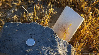
There were two real bones to be seen in the visitor center, and I took a photo of each. A consolation prize, as it were.


Of course, the reason for the lack of million-year-old bones is obvious to those who think about it for a few more seconds than I did at the time - not everyone is respectful of such artifacts, and their presence would surely attract looters to a site with so little security. Frankly, it made me even more appreciative of the bone I'd found in the wild, a couple years earlier.
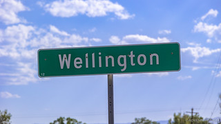
It was just before official closing time when we departed the visitor center for the final few miles to Wellington and the end of the stage. It was sweet relief as we knew that we'd be heading higher as the BDR climbed into Nine Mile Canyon and the Uinta Plateau, the elevation affording a bit of relief from the blistering heat we'd battled all day.
After filling up with fuel, there was no question about whether to continue, the only question was "how far?" You see, we knew that we were heading into a spot that - only a year earlier - we'd spent an entire day exploring; a day that had been rushed due to an imminent snowstorm. While we weren't at risk of any of the white stuff today - we'd have welcomed it in fact - we also weren't sure how we could possibly do justice to what we were about to experience in the little time we had left in the evening...
The Whole Story


")


Love Backcountry Discovery Routes? Check out
BDRs we've run
to find your favorite.


")
")
")


")
")
Great trip, awesome photos , well written. They just seem to get better and better. I look forward to each installment.
Thanks Ken! Always nice to hear when you enjoy the stories and pictures! Had a great time on this one - Utah is always such a fun state to visit!
Thanks much for another unique adventure and great photos in spite of no bones! My experience in the wild over many decades is that at the more remote places ranger stations/visitor centers often do NOT conform to posted schedules. We've encountered offices that were locked up in the middle of visitor days/hours with no explanation. Maybe they were out on patrol but we'll never know.
Yeah, I don't really mind the schedule thing - I totally get that, even if it's a bummer. The whole "there are no bones here," when one is visiting the Jurassic National Monument seems like a bit of a miss to me though. I mean sure, on further reflection I understand the problem with looting, but there has to be some solution. We've figured out a way to protect other archeological treasures...though, not always well, I suppose. ?♂️
As always, glad you enjoyed the photos. Next one is around the corner - Monday perhaps - as I've been out making more memories the last few days with @mini.turbodb.
YES, you're correct, if visiting a dinosaur park you'd expect some bones and there needs to be some kind of allowance made that will stop looting but still give the public something to see. Same kind of thing with the petrified forest. When I was a kid and we visited there were many petrified trees but now people say that the majority were looted before the Park Service did anything. Here the local California Poppy Reserve sometimes has almost no poppies within the park (and there is a fee to enter) but less than a mile away there is usually a much larger super bloom outside the park. Being local we know the best places, still it can be disappointing for tourists. In any case, you always supply some very entertaining adventures & pics of places we'd never see otherwise and a big thanks for that! Now that the tent is gone I have some room in the truck so I'm happy about that but I'll never sell on eBay again, very expensive and huge delay in getting paid!
This is a great read and I really enjoy the knowledge and research of the areas. America has so much great history and you and @mrs.turbodbexpose us to sites many will never see.
Thanks Bill - as always, glad you enjoyed the story and photos!