

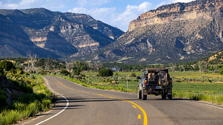
Shortly after 6:00pm, we pulled out of the Chevron station on the outskirts of Wellington on our way to Nine Mile Canyon. We were surprised when we discovered that Nine Mile Canyon was on the Utah BDR because when we'd visited - a little more than a year earlier - we'd spent an entire day in the canyon, completely overdosed on rock art, and still hadn't seen but a fraction of what it has to offer.
How then, could the BDR creators possibly expect riders to get a feel for this special place? The answer, we'd discover, was not the one we'd have come up with.

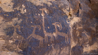
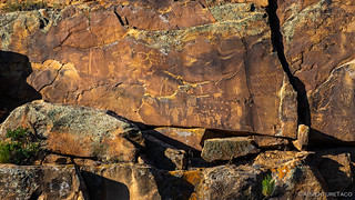
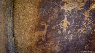
Often described as "the world's longest art gallery," the 46-mile long Nine Mile Canyon provides visitors with a myriad of opportunities to enjoy more than one thousand rock art sites that have been identified in the area, though archeologists believe that 90% of the art may yet be undiscovered!
Most of the rock art was created by the Fremont culture and the Ute people well before the canyon became a main transport corridor in the region during the 1880s. Settlers established a number of ranches in Nine Mile Canyon, and even a short-lived town named Harper. Today, much of the canyon remains private ranch land, though the rock art of the canyon is protected and largely viewable by the public.
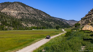
Just reaching the canyon took us the better part of an hour, so there was no way that we were going to be able to visit - much less enjoy - even the most well-known of the rock art sites along the 46-mile route before finding camp. Additionally, though we'd gained a few thousand feet of elevation - making the temperatures much more pleasant - to reach the mouth of the canyon, we'd lose that same elevation as we explored deeper into gallery of rock art.
Still, we're - though really, I shouldn't blame @mrs.turbodb at all - a stubborn bunch, and I felt bad calling it quits two hours before sunset when the temperatures were so pleasant. So, we left a few of our belongings in the spot we hoped to call home, and set out to see a few of the petroglyph panels along the first twelve miles of Nine Mile Canyon.


Just visiting these few sites, we had less than half an hour until sunset. It was only at this point that we realized how the BDR was going to "solve" the problem of allocating an entire day to exploring this magical place: the route was going to bail out of the canyon at the first possible chance, leaving the remaining - and frankly, best - 36 miles of rock art completely unexplored.
Lame.
Heading back to camp, we mused about the decision. Ultimately we decided that it probably wasn't all that surprising - the BDRs often skip the "best" stuff in an area in order to optimize around the lowest common denominator, or getting from point A to point B with as little risk as possible. It's the tradeoff they make when they are building routes for the masses, and one of the reasons that we always value the side trips and detours that we add along the way.

After a tasty dinner and a quick look around for any hidden etchings - which we didn't find - we set about our usual nightly routine and climbed into the tent just as the stars were making themselves known. Temperatures were perfect, somewhere in the low 60s °F, and a gentle breeze blew through the netting that kept the nasty little blood suckers from feasting on us throughout the night.
The following morning...
We were up at sunrise - or even slightly before - to get an early start on the day. This wasn't going to be our last day on the trail, but with stages 4, 5, and 6 remaining, we figured that a couple long days might be enough to complete our trek through Utah to the Idaho border.
Having already explored "the entirety" of Nine Mile Canyon through which the BDR passed, we didn't stop at all for the first ten miles - simply passing by the rock art we'd checked out the evening prior.
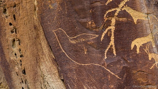
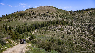
However, our fast pace changed as soon as we hit the BDR's bail-out road at Argyle Canyon. Within just a few dozen feet, we realized that the artists who wandered these canyons didn't discriminate between one canyon and the next - or, while they may have preferred one over the other, none were off limits. For the next two hours, our progress slowed dramatically as we glassed the varnished sandstone and climbed from one panel to the next.

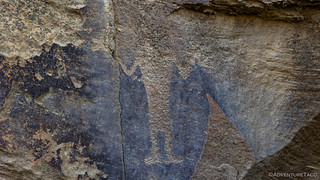


Native American Indian etchings weren't the only ones adorning the canyon walls.

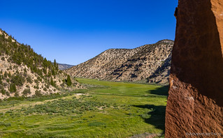
Eventually - as we climbed out of the canyon - the walls decreased in height and the valley floor stretched wider and wider. There was no rock art here, but the grassy pastures and ranches nestled into stands of cottonwood trees made for plenty of pauses along the way.
From Argyle Canyon we climbed onto the Uinta Plateau, our path along Reservation Ridge affording us views of the Wasatch and Uinta Ranges to our west and north. There - as we were stopped for breakfast - a Jeep pulled up and out hopped a couple of locals. One in his seventies and the other in his teens, we shared stories of our explorations, the grandfather regaling us with stories of roadless ridges and dog hunting of years gone by. As were we, these two were out making memories and thoroughly enjoying their morning.

Continuing on our way, we were engaged in a conversation about how - no matter what BDR we find ourselves on at any given time (and this isn't just true of BDRs) - every single person has been friendly and engaging. Perhaps we've just been lucky, but these chance encounters always add so much color to an area that we're constantly looking for folks to run into. Fire lookouts, BLM or USFS or NPS employees, or anyone out enjoying the same things we are. And then...
Whoa!
Whoa-Whoa-Whoa-Whoa!
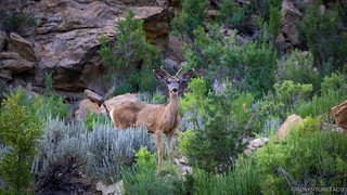
The smallest baby deer we've ever seen darted out in front of the Tacoma. I was sure he was a gonner as I slowed to a stop, my eyes glued to the side view mirror.
Not more than a foot tall, I was relieved to see the little guy wobbling through the belly-high grass. I'd somehow managed to slow down just enough - or he'd swerved just so - in order to miss him.
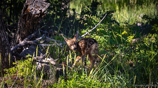
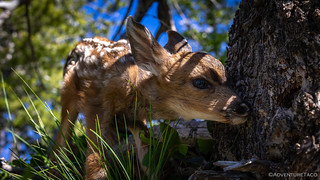
After a couple photos and ushering the fawn back to its original side of the road - in case mama came looking - we continued on, eventually heading down through Timber Canyon and along the Strawberry River, temperatures rising once again as our elevation dropped from 9,300 to 6,000 feet.
Our descent was far from uneventful. Now nearly at the end of the stage, we ran into one of the first closed gates of the trip. Thinking nothing of it - and perhaps even grateful that it wasn't a flimsy barbed-wire contraption - @mrs.turbodb hopped out to open it up. Calling me over after a few minutes of fiddling, we ended up struggling with the chain for 10 minutes - someone having squeezed a carabiner through a link, with no consideration as to its later removal - before impersonating the UTVs we despise so much.


It was only when we reached the bottom of the canyon that encountered the road closed sign. Not for the path we'd travelled, but for the only other route that we might have taken from Reservation Ridge to the end of the stage at Currant Creek. Without that narrow cattle guard, nearly an entire day would have been lost to retracing our steps... or somehow destroying that damn carabiner.
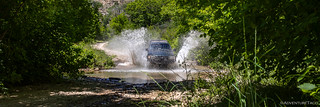
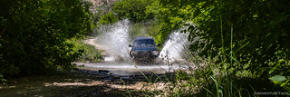
For now though, we enjoyed the valley as it opened up around the Strawberry River, grand walls towering towards the sky, folks camped here and there, and children splashing in the muddy water.

Before long we hit pavement, the end of the stage only a few miles north. Hungry, we looked for any shade we could find, the best spots already occupied by campers and their 25' toy haulers.
Lunch would just have to wait.
The Whole Story


")


Love Backcountry Discovery Routes? Check out
BDRs we've run
to find your favorite.


")
")
")


")
")
Beautiful country. Always amazed at how diverse Utah is from red sandstone to green mountains. Thanks for sharing.