
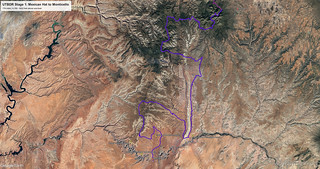
It's hard to say that it was way too early when my alarm went off at the base of Mexican Hat, but it's safe to say that we'd gotten way too little sleep given our arrival at this place only three hours earlier. Still, with daytime temperatures in the triple digits, we were no dummies - though one might argue otherwise given our voluntary arrival to such conditions - and planned to get as many miles in while it was still relatively cool outside, as possible.


In finding a place to set up camp in the wee hours of the morning, I'd hoped that we could stop somewhere in Monument Valley - still on the Arizona side of Utah's southern border - so that we'd begin the first day of the BDR by crossing into Utah. Unfortunately - and probably obviously to anyone who's done even a little bit of research on the area - Monument Valley is completely on Navajo Nation land. And, while there's a bit of BLM sprinkled here and there, it's hard to get to - at least in the middle of the night - and we weren't in any shape to hunt. So, our first order of business upon packing up camp was to head a few miles south to the town named for the rock where we'd camped, and the official start of the UTBDR.

Officially underway, our first order of business was to slow down our rate of progress by abandoning the route, peeling off the trail in order to visit one of the more dramatic overlooks of the San Juan River. We were early enough in the morning - still before 7:00am - that the ticketing booth wasn't open, allowing us to eat a free breakfast with a colossal view.


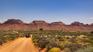
A bit of cereal in our bellies and the air already starting to heat up around us, we were soon back on the trail and headed for the Valley of Gods. Like much of the first two-and-a-half stages of the route, we'd visited this valley on previous adventures, but the mesas never cease to impress. Still, we took fewer photos this time, hoping to put a few miles between us and the starting line; knowing that we had a few more extracurricular activities to enjoy before wrapping up even the first stage of the BDR.


Surprisingly - or at least, unlike the previous times we've visited - we encountered very few other people in our hour-long traverse through the Valley of Gods and approach to the Moki Dugway. This would be the first time I've climbed the curvy, 10-mile road to the top of Cedar Mesa before late afternoon, and I was looking forward to experiencing it - literally - in a different light. It's also a place that would benefit significantly from the perspective that a flying camera would afford.


Our second detour awaited as we reached the top of the Moki. A few months earlier, I'd camped below Cedar Point as I explored Johns Canyon, but while I'd looked up at Muley Point, I'd never gotten to the top - too many other destinations vying for my interest. Today - as temperatures began to climb into the uncomfortable range - we'd change all that. We'd also - it turned out - find all the folks who are usually in the Valley of Gods, a few thousand feet higher, trying to escape the blistering temps.


From one off-BDR jaunt to the next, we headed north on UT-261 through the heart of Cedar Mesa - Bears Ears National Monument omnipresent in the distance - towards Snow Flat Road. Still on the route at this point, we headed east as we exited pavement, pausing briefly to air down to 16psi for the remainder of the trip. This was a place I'd been before - solo - on one of my trips in search of the prolific Ancestral Puebloan ruins that decorate this land. It was a place I'd thoroughly enjoyed, and was excited to show @mrs.turbodb. It was, The Moonhouse.
Note: Visiting Moonhouse requires a permit, and it's day use only. A maximum of 20 permits per day are issued on a first come, first-served basis. From March 1 through June 15 and September 1 through October 31 (high use seasons), 12 of the 20 spaces are available to reserve at the Cedar Mesa and Bears Ears National Monument Permits Recreation.gov page at least five days but no more than 90 days in advance of the entry date. The eight remaining spaces may not be reserved in advance and are only available by walk-in at the Kane Gulch Ranger Station on the morning of the hike. Permit fees are $5 per person during the high use seasons, including a $6 transaction fee for reservations. All permits (including reserved permits) must be picked-up in person at the Kane Gulch Ranger Station during the high use season. The maximum group size is 12 people.
From June 16 through August 31 and November 1 through February 28 (low use seasons), Moon House permits must be reserved at the Cedar Mesa and Bears Ears National Monument Permits Recreation.gov page before arrival.
For more information, check out BLM Utah Cedar Mesa Permits and Passes Information.


While there's no questioning the ruins themselves, my favorite attribute of the Moonhouse is the rock art. There aren't grand panels of life-sized figures, or intricately etched shaman to be found. Rather, the rock art seems to decorate the space as though it was a home. Understated, yet elegant.


It was nearing noon as we reversed our descent-climb direction through McCloyd Canyon, our sights set on the back half of the Tacoma we'd left in a small bit of shade we'd found near the trailhead. There, @mrs.turbodb whipped up a couple turkey sandwiches with the fixings we'd picked up the previous afternoon, the new Dometic fridge humming away in the 100°F heat to keep everything at a perfectly acceptable 37°F.
Bellies once again satiated, we flipped the air conditioning lever to MAX and resumed our adventure down the eastern flank of Cedar Mesa. Our next planned stop was the petroglyphs at Sand Island Recreation Area - just west of Bluff - but of course I can travel more than a few miles without exiting the truck to marvel at the world around me, and this time was no different.
Plus, it allowed a bit more time for my copilot to enjoy her early-afternoon siesta.


Given the heat, we opted to skip the Upper Petroglyphs - a spot we'd visited a couple years earlier on our way to the beginning of the New Mexico BDR (NMBDR), though in cooler weather we'd both encourage explorers to visit some of the most unusual petroglyphs we've ever seen!
Instead, we once again retreated to the cab - a theme that would be reinforced over the course of this adventure - where it was warm but bearable, unless one was unlucky enough to have the sun streaming through their window. Which, somehow, usually, happened to be the case for me.

There is so much to see along the length of Butler Wash that we didn't even consider looking at any of it. Hikes to ruins and rock art sites range from a mile to more than five miles off the road, sometimes scaling the entirety of the sandstone monocline to the top of Comb Ridge. It's an area where we could - and have - spent days just exploring the nooks and crannies. And yet, on this particular day, our desire not to bake under the mid-afternoon sun far outweighed any desire to discover anything we'd missed on previous adventures.


Eventually we reached UT-95, crossing over the pavement to much more mountainous terrain than we'd found ourselves to this point in the journey. We'd entered the south-eastern Abajo Mountains. A checkerboard of BLM and Ute Indian land, this is another place - as we worked our way along Elk Ridge - where Native American rock art and ruins are plentiful. Today though, we were there to enjoy the mountains themselves.


In fact, we gained more than 4,000-feet of elevation in the next few hours as we wound our way north through the Abajo Mountains toward Monticello. At the beginning of the day I'd been a bit worried that we wouldn't be able to complete all 174 miles of the stage in a single day - especially with the three side trips taking up a few hours - but suddenly it was looking as though we might actually pull it off.
And that wasn't necessarily a good thing, either.
At significantly lower elevations, if we had to find camp along the second stage of the BDR, we'd certainly be less comfortable - temperature wise - even if we might shorten the trip by an hour or two.
Not that it mattered. Our concern about where to stop was a clear case of counting chickens - a point I'll get to shortly. 


By the time we reached the high-point at Jackson Ridge - just under Abajo Peak and only about 10 miles from the end of the stage - it was nearing 7:00pm and we'd decided that we ought to find a camp site. That would allow us to enjoy dinner in a much more pleasant 85°F, and would afford us nighttime temps in the 50s °F rather than something completely unbearable.

And then, completely out of nowhere, we hit a gate. This wasn't just any gate, it was one of those big, bad, metal gates that you can't really do anything about except for cry when you run into them.

At first, I thought it was a mistake - I mean, we hadn't run into any - and I mean any - snow as we'd climbed to this point along the trail. The road - a gravel, well-graded one, easily passable by a sedan - was heavily traveled by folks trying to get to Monticello. And seriously, it was already mid-summer - the 4th of July!


On the bright side, the closed road - which I'd discover the next morning to also be gated and locked at the other end - made it easy for us to pick a camp site at what was essentially the highest elevation of the day. A few miles back, we'd passed a scree field that extended out from a bend in the road - the perfect spot to get us off the dusty gravel and set up camp for the night. So, that's just what we did!

After a dinner of fried chicken wraps - yum, we should do that again (!) - we putzed around at the edge of our personal scree field as fireworks popped off 30 miles away in the night sky above Blanding. They were too far away to hear, and not much larger than the eraser of a #2 pencil, so I think we only watched a few of them before opting to catch up on the sleep that we'd missed before setting out on this scorching journey.

The following morning...

We slept fantastically on our perch in the Abajo Mountains, but we knew that it'd be another early morning - both to take advantage of lower temps, and because we had a 45-mile reroute through Blanding and Monticello in order to reach the beginning of stage 2. As such, we opted to skip breakfast for the time being, retracing some of the path we'd taken the evening before, now in a different light and nearly unrecognizable!


We made good time down the mountain, and after filling up at the Maverik in Blanding - a convenient place for a bathroom break as well - pavement carried us the 22 miles to Monticello and the beginning of stage 2.
Except that we weren't planning to do stage 2. Yet.
The Whole Story

")


Love Backcountry Discovery Routes? Check out
BDRs we've run
to find your favorite.


")
")
")


")
")
Loved Muley Pt. But was worried about our dog going over the edge so we opted for Valley Of the Dogs.
Was the gate you encountered on an 'official' BDR map or guide? I found a few such encounters on sections of the Colorado BDR so I am curious as to whether new obstacles are being established and the official BDR isn't being updated accordingly?
Good start to your BDR series, and I am remembering my camping in Valley of the Gods and up on Muley Point.
That gate has been there a long time I think. It's a USFS gate, which closes the road during the winter when it's impassable to vehicle traffic and used as a cross-country ski area.
Given that we were just below the snow line, my guess is that the USFS just hadn't opened it for the season yet, and I'm sure it's open now (unless there's some larger washout further down the road).
I did let the RideBDR folks know about it when we ran into it, so they could post an update on their site and inform others to ride a different route, but they never updated the site... too busy to be bothered, I suppose.
Another beautiful adventure. Thanks for sharing.