
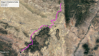
Stage 6 of the New Mexico Backcountry Discovery Route - Grants to Cuba.
It wasn't even 4:00pm when we headed out of Grants to kick off the sixth stage of our route. With only two stages remaining, it was looking like we'd complete the entire route in just under a week - hopefully giving us a day or two of leisurely making our way home, exploring along the way.
The reasons we were watching our time was that the sunny days we'd enjoyed so far - even if they'd be hot - were about to change; a storm system was rolling in. And that meant the trails could get interesting.

Into the Cibola National Forest.
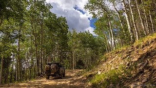
Up, up, up - into the aspen.
As was becoming a theme upon leaving each checkpoint, one of our first orders of business was deviating from the mapped route to explore a fire lookout. This time we were headed up to La Mosca Lookout, just a couple miles from the tallest mountain in the area - Mt. Taylor. And, as usual, our fingers were crossed that the road would be open and the lookout, staffed.

First sight.

Looks promising.
When we reached the summit, we were elated. And it was windy! Gusting over 40mph according to the NOAA weather report on the ham radio, we held on to our hats as we walked the final switchback to the lookout.

It's always good practice to park where the lookout staffer is parked, so we walked from here.

At just over 11K feet, our highest elevation of the NMBDR. We wondered while here, is this the highest road in the state?
Unfortunately, and unlike the other lookouts we'd visited, the person staffing this one was clearly not interested in any sort of interaction with visitors. Secure behind closed doors and shut windows, he completely ignored us as he glassed the surrounding area. Waves were not returned. Understandable perhaps, given the close proximity to a larger town, and the higher amounts of traffic he likely had to endure.
The views, however, did not disappoint.

There's rain falling from those clouds. The weather is a-changing!

What is that?! Don't worry, we'll find out later. 
Whereas we'd generally been heading back to the truck to escape the heat, this time we jumped back in for shelter from the winds - heading north, our noses pointed toward the ominous weather in the distance.
We were both hoping for the best, but it sure didn't look promising with a horizon like this...
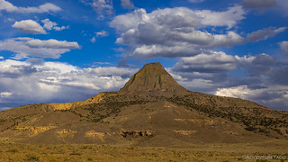
A little less than half an hour later, it was simply amazing how things had changed. Sure, there were still clouds around, and yes, it was still quite windy - but the sun was out again, the temps were back in the high 80s °F, and holy smokes, we found ourselves a that crazy point we'd seen in the distance from La Mosca Lookout!

I present Cerro Alesna.
Closer.

Wow.
A volcanic plug, Cerro Alesna was created when lava hardened within its vent. Eventually, erosion deteriorated the surrounding rock while the erosion-resistant plug remained, producing a distinctive upstanding landform. Apparently, this was common in this part of New Mexico as we'd see several other volcanic plugs in this area as well.
Having rubber-necked our way by Cerro Alesna, we were still turning our heads back to look at it when we came upon a reasonably large, and well-preserved ruin of an old ranch. With several structures including a stable, tack barn, and living quarters - as well as several large corrals - we got out to explore.

The long stable, with windows for the horses on the far end, and a tack shed in the windowless area.

High winds that frequent this area had clearly taken their toll on several of the roofs here. Apparently the wooden framing supporting them simply rested on the stone walls, allowing it to be blown off.

"I told you I'd close up your window if you kept sneaking out, Johnny!"
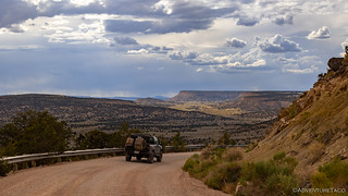
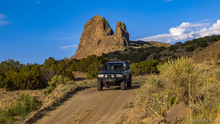
Now nearing 6:30pm, we'd covered quite a bit of ground since leaving Grants - the roads here just as graded as the rest of the route. That said, the landscape was finally what I thought of when I think of New Mexico - bluffs and mesas rising up in the distance, the landscape more desert than forest, and we were thoroughly enjoying it.

Well hello New Mexico, where have you been the last five days?
Given the time, we had a quick look at the map and noted that much of what we were travelling through from our current location - and to the end of the stage in Cuba - was private land, much of it owned by the Lee Ranch Coal Company, several extremely large open pit mines just visible on the horizon. There was however a bit of BLM land interspersed here and there, and we knew that we'd need to find camp somewhere in those areas. With just under two hours until sunset, we decided to look for something that would shelter us from the 30mph southwesterly winds - and 45mph gusts - that were predicted overnight.
With that criterion stored away, our heads were back on swivels as the road undulated across the desert landscape. Out of the corner of my eye, I noticed something that wasn't quite as natural as everything around it and pointed to @mrs.turbodb - "look!"

Patricio Trujillo 5-12-1903

Luis Mesas was here, in the year 1894.

A little more recently, Roger Pino, in 1960.
Completely by coincidence, we'd stumbled upon our own Inscription Rock on what has clearly been a path of travel for hundreds of years. It was a cool find, and reinforced for me the joy of discovery. So often these days, people just want to know "where to go," in order to see something cool or get that #instafabulous photo. A beeline to a set of GPS coordinates. But that kind of travel - more often than not - means that the surprises like this one are missed, and those discoveries can be the most memorable.
Flush with our find, we continued on towards the BLM boundary, my hope that a distant mesa would be our stopping point for the evening. As luck would have it, Mesa Sarcio couldn't have been more perfect. Straddling the property line, the southwestern half on private land but the wind-sheltered northeastern half under the purview of the BLM!

A primo location!
The horseshoe shaped mesa allowed us to nestle into the fold, cutting wind speeds by 75% or so. And, the interior perimeter was eroded enough that after a quick bite to eat, we were able to hike up to the summit to enjoy a spectacular sunset.

Yeah, this is our best camp site so far. By a long shot.

Sunstar on the horizon.

The purples only come out when the sun isn't there to chase them away.
It'd been another successful day, but I'd be remiss to mention that I was a bit worried as we nodded off to sleep. 0-3 inches of rain were predicted overnight and into the following morning. While a little rain might not have been a problem, the ground we were camped on could present some rather significant issues if it got too wet - the silty material turning to goopy mud.
There wasn't much we could do now, we'd just have to deal with that in the morning.
The Following Morning...
I'd set my alarm early - partly because I hoped that the mesa would afford a nice sunrise view, and partly because I wanted to be able to get out fast if the ground around us was turning to soup.
The news was both good and bad. On the good side, there'd been no rain at all overnight, and it didn't appear that any was due for at least a few more hours. On the other hand, it was cloudy on the eastern horizon, so a spectabulous sunrise wasn't going to be in the cards. Not that the morning light was dreary or drab by any means.

Cerro Alesna in the morning glow.

The wind was still ripping through camp; we were lucky to have found such a sheltered spot.
Not knowing how long we really had until the rains came - if they came at all - we didn't hang around to find out, and there were still long shadows cascading across the landscape as we pushed further into the rocky New Mexico outback.

I could get lost here for a week.

Hoodoos are created when a harder layer of rock (often volcanic) is deposited on top of relatively soft material (usually sedimentary). The stone cap then protects the column from the elements.

Looking the right direction, and with the wide-angle lens, the perspectives and colors were magical.
Hoodoos weren't all we saw and the road traced a northeasterly course towards Cuba. Crevices in the flatlands were plentiful, and we dipped in and out of the myriad of washes a few times. The badlands were a good reminder that this area was soft and that we really didn't want to be here when it rained.

One of nature's fractals.

Battleship Mesa. On the hunt.
I mentioned earlier that there were several volcanic plugs along this section of trail. Cerro Alesna was the most dramatic (by far), and Cabezon Peak was certainly the tallest. But I'd say the dual plugs of Cerro Parido were up there in the running for most interesting. The thought - that there was a volcano here with not one, but two vents - and the preservation of that form over all these years... well, that's pretty neat to wrap your head around.
Reminded us of Three Fingers Rock (a triple volcanic plug) in the Owyhee Canyonlands.
A few miles later, we got a bit of a surprise. Here we'd been, driving along on what we thought was the valley floor, mesas rising up around us. But then, as we rounded a bend, an even lower valley opened up below us - we'd been driving on a mesa the entire time!

Though the sun wasn't in the best position for photos, I really liked the lighting over the valley.

Over the course of the next several miles, the light became more filtered - high clouds obscuring direct sunlight.
We continued on - past Cabezon Peak ("big head") - before turning north. The Pueblo and Navajo Indians believe that the peak has religious significance, and while we didn't have a chance to hike it, remnants of their visits are still visible to those who do. One Navajo myth goes thusly: after a giant was slain upon Mount Taylor, his head remained as Cabezon Peak and his blood congealed to form the Malpais, or bad-land volcanic flow south of the peak.
Despite nearly constant prodding from @mrs.turbodb, I got no photos of Cabezon, as the sun was almost immediately behind it, rendering it little but silhouette. I did however take a photo in the exact opposite direction.

A mini break in the clouds made for a dramatic view to the north.
Two minutes later, our route joined up with NM-550. For 30 miles we pounded the pavement, an air of familiarity just out of our grasp. It wasn't until we crossed the Puerco Rio - technically "Pig River," though I imagine that "River of Bacon" might also be an even more tasty interpretation - that I realized we'd been here less than a week prior, as we traversed from northwest to southeast New Mexico to start the BDR!
Soon enough we were in Cuba. It was 10:00am, and we both agreed that the previous stage - no matter quickly we'd run it - was by far our favorite. In fact, it would turn out to be the only stage that we felt like was quintessential New Mexico.

Yes, a bit of a corny photo to represent Cuba. What can I say, we must have been hungry.
And so, still having not eaten breakfast, we fueled up for the last time and set off on the final leg. We had no idea at the time that we wouldn't make it far before mud became a major factor. Oh, joy!
The Whole Story


Love Backcountry Discovery Routes? Check out the
BDR Index
for all the routes I've run - they are fabulous!


")
")
")


")
Try to get to Shiprock, NM if you can.
Enjoying your entries! Funny thing, though: most of us in NM are always on the lookout for trees to camp near!
LOL, I don't doubt it! Just wasn't what we'd envisioned as a trip to the southwest! Probably the same way us up here in WA are always looking for breaks in the trees so we can see the sky, but everyone who comes here expects to be in the forest all the time! Glad you're enjoying the stories! ? ?
We got absolutely nailed by rain and hail on the way down from La Mosca. We were on the standard CDT route and when we got down to relatively flat ground we were stopped dead in our tracks by the mud.. had to pull over for the night. Luckily the rain stopped so we could go forward to Cuba the next day.
No mention of Chaco Canyon? On our trip in early June that was truly one of the highlights.
Unfortunately, Chaco Canyon isn't really near the NMBDR, so we didn't have a chance to visit. It, along with many other points of interest are on our long list of places to see when we go back to New Mexico, since the BDR was fun, but not quite what we were expecting from a state with so much desert and Native American/Indian history. Plus, we'll want to spend more time exploring places like Chaco Canyon than we would have had on this trip, so that's just another good excuse to have skipped it this time! ? Hope you enjoyed the story so far - still a couple more parts to go!
"....So often these days, people just want to know "where to go," in order to see something cool or get that..."
That quote above is so incredibly true Turbo. Thanks again for your stories and inspiration. Y'all stay safe and keep exploring!!