We were already halfway through our day, so we hoped to make quick work of the pavement between Terrace, British Columbia and Hyder, Alaska. We would be in the 49th state for only a few minutes - our actual destination was back in maple leaf territory - but it'd be the first time either of us had ever been to the largest state in the Union, so we were both looking forward to the opportunity to visit.
First though, we had to get there. And getting there on BC-113 turned out to be more eventful than we'd bargained for!
Right off the bat, things were already looking better than they had earlier in the morning over Telkwa Pass. The skies - now blue - were dotted with puffy white clouds, and the turquoise water of Kitsumkalum Lake lay perfectly flat as we raced along the shore.
But for the blue vs. green, it was almost hard to tell which way was up.Through paradise.
There are lakes everywhere, but there are few places where they are surrounded by pristine wilderness and glacier-covered peaks. In that sense, British Columnbia seems a bit like Moab - a place on Earth that won the landscape lottery.
Oscar Peak towered above Lava Lake as we continued north.
Thoroughly enjoying the views, even our few stops for photos did little to slow our pace on the well-maintained pavement, and soon we found ourselves in the Nass Valley and more specfically, the Nisga'a Memorial Lava Bed Park.
Established on April 29, 1992, the park was expanded to 178.93 sq km in 1995 and became the first park in the province to be jointly managed by the Canadian Government and a First Nation as part of the Nisga'a Treaty in 2000.
The park is believed to be the location of Canada's most recent volcanic eruption and lava flow - a geological disaster that killed an estimated 2,000 people - from the Tseax Cone, around 1700. This flow damned the Nass River and destroyed two villages - Wii Lax K'abit and Lax Ksiluux - of the Nisga'a people.wikipedia
One of the more prominent features of the park from the highway are the vast lava beds. These reminded us of those we'd seen in Iceland, and I couldn't help but stop for a quick look at the mosses and lichens that covered the vast expanse.
Be careful where you step, this stuff takes decades to grow.New growth.Tiny trees.
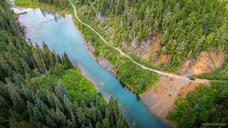
But even the lava field - or at least, the lichen-covered variant - was not the most intriguing aspect of this remote route. Rather, it was the flooded floor of the Drowned Forest - technically part of the same flow - that caught our eye as we wound our way through the woods. At first, it didn't seem like much - just another magnificently colorful creek along the side of the road. But then, as @mrs.turbodb went suddenly quiet as she peered out her windows, I caught a quick glimpse of the magical landscape.
Mesmerizing.
Fed from Lava Lake, the colorful water only floods the forest during periods of high water, but when it does, it's a sight to behold. Rushing around roots, it's unlike any forest we've seen, striking enough that we turned around twice to get a closer look.
A land of enchantments.
Not long after is where things really slowed down. Unfortunately, this wasn't because we ran into one amazing sight after another. Nope, this was due to the road transitioning from pavement to dirt. Usually we'd welcome such a change, but on this particular day there were three things conspiring against us - traffic, dust, and potholes - that would make the subsequent 64 km, miserable.
Looking back, I suppose we should have been thankful that - in this northwestern corner of British Columbia - it was only 40 miles. Still, even as we reminded each other that this was the same road that'd provided us with the lava beds and otherworldly forest, it was hard to feel thankful as each massive pothole attempted to remove teeth from our jaws.
Thankfully the Tacoma's well-tuned suspension, combined with liberal application of skinny pedal, and our bumper-mounted-mini-suns - meant that the experience lasted only an hour before we reached the intersection with BC-37, where we were once again blessed with a double yellow line.
Mt. Johnson, American Peak, and Mt. Pattullo of Bear Glacier Provincial Park.We could hear the thunder as we approached Meziadin Junction, hoping the storm would blow through before it was time to deploy the tent!Only the tip of the Bear River Glacier is visible from the highway, but this was not the glacier we were looking for.
And then, with little fanfare, we reached the United States. We'd gathered all of our paperwork in preparation for crossing the border - hoping that our appearance at 5:22pm would not mean that the good folks who monitor these crossings had gone home for the night - only to find that there was no guard station at all.
No border wall. No ICE agents rounding up non-citizens. Canadians, apologies and all, were crossing willy-nilly. Somehow, someway, and against all odds, everything seemed fine.
So friendly they're almost Canadian."Home"-ish.
And then, danger. As we rolled north through this narrow slice of the United States, we were brutally accosted by a foreigner. We know he was a foreigner because he looked nothing like us. If fact, he could have been a she, that's how obvious it was that it was a migrant. And the accosting was more of an ignoring, but let's not get bogged down in the facts.
Border invader. Stealing our salmon.
After sticking around for a few minutes in the hope of catching a few more of our four-legged friends crossing the border, we continued our climb up Granduc FSR toward several old mines, and the main attraction: the fifth largest glacier in Canada, the Salmon Glacier.
Located on the eastern slope of the Salmon River Valley, Premier Mine was started in 1910. By 1918, Premier had developed into one of the richest mineral deposits in B.C. An 11 mile (17 km) aerial tramline was constructed to carry ore from Premier to tidewater and was one of the longest on the continent at that time. In 1921 the property shipped 6,000 tons of ore with the gold valued at $1,500,000 at that time.
A large fire devastated the camp in 1928, resulting in the destruction of most of the buildings. Through heroic efforts, the mill machine shop, compressor plant and tramheads were saved. These were vital to the operation of the mine as loss of them could have resulted in the closure of the property. The camp was rebuilt and Premier Mine Camp once again became a thriving community.
Many years of success and continuous operation were experienced until low base metal prices forced closure in 1953. Development resumed in 1955 and continued sporadically until 1967. The property sat idle from 1967-1988, other than some exploration in the early 80s. In 1988, Westmin Mines began construction on the property and undertook open pit mining from 1989-1992. During these years, another ~260,000 oz gold and 5.1 million oz silver were added to the mine's tally before care and maintenance (reclaimation) began in 2001.Glacier Highway and Salmon Glacier Auto Tour
Today, the Premier Mine is open again - this time operated alongside several other properties in the area, including the Red Mountain, Silver Coin, Big Missouri, Dilworth, and Martha Ellen - run by Cambria Gold Mines. Centered on the existing 2,500 ton/day mill, grid power from a nearby BC Hydro project, and the underground workings already in place, Cambria plans for a phased restart. Drilling is underway at Premier, while ore processing begins at the Red Mountain Deposit.Cambria Gold
The hub of today's Premier operation.Parker has more rock trucks. Just sayin'.
After a quick stop to admire the heavy machinery, we pushed on. Our ultimate goal - the ghost camp at the old Granduc Mine - was another 20 miles up the valley, and there we were sure to be distracted by old mining relics and Canada's fifth largest glacier along the way.
Eleven minutes later, the distractions began, as we reached the toe of the largest drivable glacier in North America.
South toe of the Salmon Glacier.Slow flow.
We'd stop several times over the next five miles - the length of the southern arm - to admire the views. We'd probably have stopped more, but for a caravan of six enormously outfitted trucks that screamed "we are overlanders, and we will dust you" (literally) that were chasing us up the road.
Reaching the summit just before 7:00pm, we hoped that this would be the terminus of the action-camera parade, and hopped out for a quick photo before heading along the northern toe of the glacier, toward the old Granduc camp.
Summit overlook.
During Granduc Mine's heyday in the 1970s, workers were transported daily by bus from Stewart up the Granduc Road, but in winter the heavy snows at this point made the road unsafe, so the mining company built a mile-long tunnel through the mountain.
Winter road.Light at the end of the tunnel.Continuing toward the old camp, we discovered the most picturesque excavator in existence.
The Granduc Mine was an amazing engineering achievement. The actual excavation of the ore - some 420,000,000 pounds of copper over its lifetime - took place 11 miles to the west of the Tide Lake entrance at the foot of the Laduc Glacier, but that area is inaccessible from the surface due to intervening glaciers and mountains. So, in order to extract the copper ore that had been discovered there, the mining company designed and built an 11-mile tunnel from Tide Lake to Laduc Glacier. Originally, in 1964, the plan had been to bore the tunnel from both ends, but an avalanche occurred at Laduc Glacier when that end of the tunnel had been dug a mere 28 feet, killing 26 miners.
Ultimately, the tunnel was completed from the Tide Lake side and a railway was laid to take the workers to Laduc and to return the ore from there to a concentrator at Tide Lake. At Laduc, the ore was extracted as much as a mile below the surface and partially crushed before being loaded into railcars that could carry up to 50 tons of ore. 15 to 20 of these cars were pulled to Tide Lake by electric-powered locomotives traveling at 40 mph, through tunnels a mile below the surface!
Tide Lake. So named because it rises and falls each year with melt from the Salmon Glacier.
At the north end of Tide Lake, the ore was processed at the concentrator before being taken by truck to Stewart. There, it was loaded on tankers and shipped abroad, the first delivery being made to Japan in 1971.Granduc Road Beyond Salmon Glacier
The Granduc camp is once again buzzing with activity, buildings and tents staged below the old concentrator, as the Cambria Gold drilling operation perforates the hillsides.The foundation of the Granduc concentrator (mill).
Finding the old mining camp reactivated was a bit of a bummer. I'd seen pictures of the old concentrator, a few of the old rail cars, and a couple of the adits in decades-old trip reports, and we'd been looking forward to poking around in a couple of the "totally safe" tunnels before finding a spot to camp for the night. Instead, it was clear that there would be no such wandering around; we were lucky to have shown up as late as we did, the workers mostly off the roads for the evening.
And so, after admiring the view at the end of the road, we started back toward the Salmon Glacier.
A nice place to work.
One of the benefits of having a passenger who likes to know the names of everything around us is that I'm able to share the few details my brain can recall as I write these stories. Another benefit is that she is constantly scoping out the roads we're on - and the roads around those roads - in real time. And, it was in doing this as we raced our way up Granduc FSR, that she noticed what seemed to be the perfect spot for us to call home for the night: an old mining road that traversed the steep valley walls several hundred feet below the well-graded FSR. A spot we hoped to have to ourselves.
That is, if our driver - me - could be separated from his camera for long enough to get us there.
The "stubbed" North toe of the Salmon Glacier.Breaking up.
Just as important as getting to camp was getting to camp to eat dinner. In fact, it was suggested more than once that we need not actually reach camp to have dinner, but I wanted to make sure that we took advantage of what little daylight we had left. After all, we'd driving more than two full days to reach this remote corner of the continent, even if it wasn't technically at the corner of the continent.
And so, having consumed our only meal of the day around noon - and our last snack of a shared apple and handful of nuts now nearly five hours in the past - we pushed on. Along a narrow shelf road. Over a rock slide, and to one of the most unique campsites we've ever encountered.
It was dinner time.
Home for the next 9 hours.
As @mrs.turbodb dug into the chicken pesto pasta and Asian slaw she'd prepared at home, I sent our little buddy - who is also always hungry (for electrons) - into the sky.
River of ice.Upper reaches.Flowing down the valley.
After several bowls of cellentani-shaped pasta with shredded chicken, fresh corn, home-grown sungold tomatoes, and pesto sauce, we deployed the tent and set off on foot to find the end of the road. We knew it wasn't far, and were delighted to discover that our perfect camp site was in fact the best one on the mountain. In fact, only a few hundred yards further - around a fold in the terrain - a rockfall rendered the road impassable, and there was nowhere to turn around.
End of the road.
It'd been a long day, and as we headed back toward the Tacoma, we admired the near-sunset light as it spread across the sky, Here - above the slowest of flows - the fading light softened the crystalline surface, its fissures and folds transformed into pillows by the shadows. A good reminder that we'd been on the go for 16 hours; it was time for bed.
Soft light.Closer.Best bed in the house.Good night glacier.
The following morning...
The great thing about going to sleep along the arm of a glacier is that when morning comes, you're at the arm of a glacier! And so it was, as we opened our eyes a little after 6:00am, the sun just starting to work its way down the river of ice.
For the first time in three days, the tent was dry, the never-ending breeze keeping the dew at bay. Except for the mosquitoes, it was glorious!
Today would be - largely - a mirror of the one before. Our push north complete, we would - technically - be starting our 1,500 mile journey home. We hoped to find ourselves back in Terrace by early afternoon, and enjoying that perfect camp site we'd passed up the morning before as the sun fell toward the horizon. But first we had to head back through Alaska. And to get there, we had to pull ourselves away from the Salmon Glacier.
Making our way through the rock slide that'd ensured our solitude through the night.Morning sun warming up the Salmon Arm.Racing down the valley, we caught the southern toe still sporting an icy blue hue in the shade.
As the road drew even with the Salmon River, dozens of birds dotted the shore. From a distance, the majority appeared to be vultures, and from time to time they'd battle each other, angry that the other was too close, or jockeying for position in the real-life game of Go Fish. One - different than the rest - took to the air, its bright white head and brilliant tail separating it from the rest. Even here in Canada, the pure power of a Bald Eagle was a sight to behold; and as I stopped the Tacoma to reach for my long lens, @mrs.turbodb pulled out the binoculars to get a better look.
"They're all bald eagles."
And so they were. Dozens of them lined the shores, our initial misidentification a result of their juvenile plumage. And yet, enlarged, it was obvious that these were America's bird.
Supervising the fray.
Not wanting to block the active mining road any longer than necessary, we enjoyed the river view for a few minutes before working our way back into Hyder and across the Canadian border. Unlike our escape to the United States, the Canadians work around the clock to keep the riff-raff out, but a quick flash of our Nexus cards were enough to convince them that we weren't all bad.
And with that, we were back on pavement. We'd take a slightly different route than we'd suffered through on the previous afternoon. While 4 miles longer - and so not even listed as an option when I'd plugged in our destination to Google Maps - the paved route along BC-37 would skip the 40 miles of dirt, and give us some new scenery to boot!
And boy, did we get some new scenery!
Out for a jog.Stopping to smell the flowers."Do I smell berries?""I love berries for breakfast.
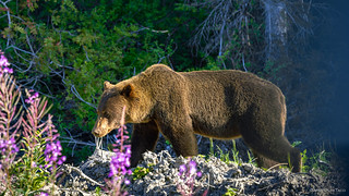
I'm not entirely sure that this was the first grizzly bear that I've ever seen, but I'm almost positive that it's the only un-stuffed one that @mrs.turbodb and I have seen on our adventures together. It was fun to watch this powerful beast frolicking through the brush only a few feet from the road, seemingly oblivious to our presence.
It was a great start to the day; a day that would only get better!
Another amazing backcountry adventure. Awesome scenery and some great wildlife.
Maybe we should call you the Rick Steves of the American West Backcountry.
The camp by the glacier makes want to pack up and head out.
turbodbSeptember 28, 2026
Thanks! That glacier camp was definitely a top 10, although on the particular night we were there - with all the mosquitoes - I'd rate is a 3/10. Wish those little blood suckers didn't like my stink so much.
There aren't many camp sites I'd like to return to, but that's one that's on the list, for sure.
Anthony WilliamsSeptember 28, 2026
You have never done better work with your little buddy than in this episode, which is truly magnificent. BTW, you may want to get a backup Air3s while the getting is good. The FCC is trying hard to ban dji drones, but already approved ones will be OK, but it may well become impossible to get replacements into the US. Extra props, extra batteries, and extra care would be good, too.
turbodbSeptember 28, 2026
Thanks! It was great having the drone this time, especially on some of the highways (where I don't usually pull it out) and over that Drowned Forest.
I've considered a backup, but my hope is that we'll always have access to drone tech, even if we have to order it north of the border. Plus, the flying cameras keep getting better and better, so I don't want to lock myself into 2024 technology forever. I'm old and crusty and hate change, but as my eyesight goes, I'll need all the help I can get with picture quality! 😉
Kevin LeeSeptember 28, 2026
Thanks for sharing
I’d heard the Fish Creek wildlife observatory
Is closed due too flood damage?
Any info on that?
turbodbSeptember 28, 2026
It's open again (though there is significant damage to the boardwalk), but there weren't any bears there fishing when we passed through.
Kevin leeSeptember 28, 2026
Thanks for the reply
Have you guys traveled the Alaska marine
Highway ferry, our favorite part of Alaska
We’ve been everywhere but Cordova
Highly recommended.
Call directly to book.
Get off in all the small towns to explore
Annan bear observatory by
Wrangell is a favorite
turbodbSeptember 28, 2026
This was the first (and only) time that either of us have been to Alaska, though it is somewhere I've wanted to do more exploring for a long time. Once @mini.turbodb is out of the house, we'll probably take a longer trip up into the northern reaches, and a boat ride is on order for sure! Thanks for the suggestion!
In 1975, I was one of the people who were "transported daily by bus from Stewart up the Granduc Road" and then on the train to the worksite several miles away inside the mountains - I was the Underground Industrial First Aid Attendant (and partsman for the mechanics). Yes, an amazing adventure, and I've been back several times, as I've lived in Whitehorse, Yukon, for the past 36 years. Thanks for this beautifully-photographed flashback.
turbodbOctober 8, 2026
Glad you found the trip report Murray, I always love hearing from folks who have a connection with the places I've been. That had to be quite the experience there at the Granduc! There's lots of work (drilling) going on at the site these days.
I'd love to hear any more stories you have of your time there. Those first-hand experiences always add so much meaning to a site like this that has so much history behind it.







Another amazing backcountry adventure. Awesome scenery and some great wildlife.
Maybe we should call you the Rick Steves of the American West Backcountry.
The camp by the glacier makes want to pack up and head out.
Thanks! That glacier camp was definitely a top 10, although on the particular night we were there - with all the mosquitoes - I'd rate is a 3/10. Wish those little blood suckers didn't like my stink so much.
There aren't many camp sites I'd like to return to, but that's one that's on the list, for sure.
You have never done better work with your little buddy than in this episode, which is truly magnificent. BTW, you may want to get a backup Air3s while the getting is good. The FCC is trying hard to ban dji drones, but already approved ones will be OK, but it may well become impossible to get replacements into the US. Extra props, extra batteries, and extra care would be good, too.
Thanks! It was great having the drone this time, especially on some of the highways (where I don't usually pull it out) and over that Drowned Forest.
I've considered a backup, but my hope is that we'll always have access to drone tech, even if we have to order it north of the border. Plus, the flying cameras keep getting better and better, so I don't want to lock myself into 2024 technology forever. I'm old and crusty and hate change, but as my eyesight goes, I'll need all the help I can get with picture quality! 😉
Thanks for sharing
I’d heard the Fish Creek wildlife observatory
Is closed due too flood damage?
Any info on that?
It's open again (though there is significant damage to the boardwalk), but there weren't any bears there fishing when we passed through.
Thanks for the reply
Have you guys traveled the Alaska marine
Highway ferry, our favorite part of Alaska
We’ve been everywhere but Cordova
Highly recommended.
Call directly to book.
Get off in all the small towns to explore
Annan bear observatory by
Wrangell is a favorite
This was the first (and only) time that either of us have been to Alaska, though it is somewhere I've wanted to do more exploring for a long time. Once @mini.turbodb is out of the house, we'll probably take a longer trip up into the northern reaches, and a boat ride is on order for sure! Thanks for the suggestion!
Outstanding, breathtaking, magnificent, brilliant, and splendiferous!!! Thank you, thank you, thank you!
In 1975, I was one of the people who were "transported daily by bus from Stewart up the Granduc Road" and then on the train to the worksite several miles away inside the mountains - I was the Underground Industrial First Aid Attendant (and partsman for the mechanics). Yes, an amazing adventure, and I've been back several times, as I've lived in Whitehorse, Yukon, for the past 36 years. Thanks for this beautifully-photographed flashback.
Glad you found the trip report Murray, I always love hearing from folks who have a connection with the places I've been. That had to be quite the experience there at the Granduc! There's lots of work (drilling) going on at the site these days.
I'd love to hear any more stories you have of your time there. Those first-hand experiences always add so much meaning to a site like this that has so much history behind it.
Wow! UJ
Thanks! (And I agree!)