
Ever since my very first trip - The De-Tour - with the guys from TacomaWorld, we've tried to get together every year for a week or two in order to explore some amazing place and enjoy time around the campfire together. I was lucky back then that Monte @Blackdawg organized the trip in a public thread, and invited anyone who could, to join. This year, after privately planning trips for five years, we tried it again - organizing a trip to the Kootenays in southeast British Columbia, Canada - with the hopes that we could meet some cool new folks and get shown around by someone we all wanted to meet - (Canada) Mike @POSTacoMike.
It'd be a little more involved since we'd be crossing borders, but with the hopes of exploring several trails deep into - and up - the Koots, there was plenty to be excited about.
As always, as blast-off approached, folks hoped to attend dropped off the list, casualties of the hustle and bustle we all know from work and life. Even Canada Mike had to bow out. Still, Monte, Mike @Digiratus, and I were all lined up.
Then, just a couple days before departure, Monte had to bail. It was a bummer, but it's also just life. And with that, it was just Me and Mike.
After meeting up just south of the US-Canada border the night before, we covered the last few miles to Nelway just before 10:00am. We'd filled out our ArriveCAN applications, ensured that we had our necessary paperwork, and prepped ourselves for the onslaught of questions.

Mike wasn't interrogated for too long before being allowed through.
In the end, it was one of the easiest border crossings we'd ever experienced. I'd been concerned because only a week earlier I'd discovered that my passport was expired. Luckily, I was able to use my (also-expired-but-still-active-due-to-COVID) NEXUS card to get across the border. Mike - his identification situation more organized than mine - used an enhanced driver's license.
From Nelway, we spent a couple hours ticking off kilometers on BC-6 and BC-3A as we headed north towards a special place. We'd been turned onto Rady Creek by (Canada) Mike the year before, and I'd even had a chance to make a run up to check it out, since it was scheduled to be deactivated (closed). Our fingers crossed that we'd find it open, we still had a couple more hours of driving as we pulled into Kaslo, where I suggested to Mike that we make a quick run up Mt. Buchanan to get our first views and consume our first lunch.

We'd been driving along the shores of Kootenay Lake for a while before we reached Kaslo.
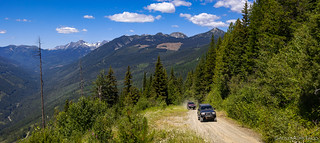
Many - if not all - of the trails I've run in Canada start in the trees. This builds anticipation, and as the trees thin, the views have yet to disappoint.
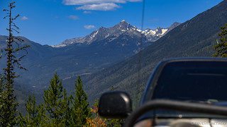
Behind us at first, glimpses of the snow-spotted Kootenays - here, Whitewater Mountain (2768 M) - began to appear.
Distant views weren't all that we enjoyed on the way up. At these elevations, late spring was still in the air, and wildflowers were in full swing. Bright colors contrasted with deep green, and we soaked it all in.

Orange dandelion flowers. I've seen these once before, on our Dead Ends trip.

Always nice to see leopard lilies. With the ground still damp from snow melt, they seemed to be everywhere in the mountains here.

Vast swathes of Fireweed lined the road.
Climbing ever higher on our way to the summit, we eventually reached the tree line. As we did, we got a great view of the Briggs Creek Fire to the west - a fire that'd started just a few days before our trip and was sending smoke southeast across Kootenay Lake.

Towering giants strained to reach the frame of our cameras.

We were lucky that there weren't many fires this year, and that the wind was blowing in a beneficial direction in relation to the areas we'd planned to explore!

Made it to the top!

Already there was more smoke over Kootenay Lake than there had been just a couple hours earlier.
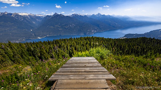
Perched atop Mt. Buchanan, a decommissioned fire lookout was fully furnished, and several picnic areas were decorated with signage, welcoming visitors to this spectacular place surrounded by mountains and lakes. As Mike got set up for lunch, I spent a bit of time poking around the lookout, marveling at how fantastic it must have been to score this location each summer when it was active.

Nicely appointed, the lookout still appeared livable. No discernable vandalism to a place like this was so different than what we seem to encounter on our side of the border.

Someone's getting ready for lunch with a view!
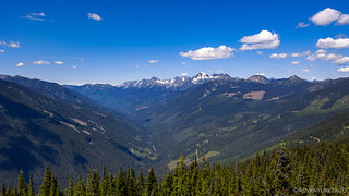
Looking north and from left to right - Whitewater Mountain (2768 M), snow-covered Mt. Brennan (2902 M), and the flat-toped Mt. Jardine (2442 M).
I only hung out at the lookout for ten minutes or so before descending the thirty feet - sorry, ten meters - or so to the picnic area that Mike had designated for our use. With the sun blazing down and temperatures in the mid 80s °F (I don't do °C  ), we made quick work of eating - both of us enjoying the warmth, but also ready for the shade of our truck cabs.

Had we arrived a little later, this would have been a great spot to call home for the night.
I wasn't sure what this was at first - and then it hit me: hangglider launch! What a nice one.

Over the next few days, we'd be exploring these Kootenays to the east.
We wrapped up lunch a little before 2:00pm and Mike took the lead as we started back down the mountain. We'd flip-flop in this fashion several times over the next several days, each of us getting spurts of dust-free driving in the front and no-rush photography in the rear. It really was a pleasant balance that was struck.

One last shot before diving into the trees.

Down we go.
North of Kaslo, the BC-31 highway transitions from pavement to gravel. I love this section of road - so different than what I'm used to in the lower 48 - a high-speed dirt highway that continues north all the way past Trout Lake and nearly to Galena Bay. Mike seemed to enjoy it too, as we made a few stops along the way to admire the scenery from the road.

Racing along, happy to be off pavement.

Still early in the trip, both Mike and the Redhead were still looking pretty clean.

The southern end of Trout Lake, we crossed a bridge at the head of Mobbs Creek.
It wouldn't be long now. Just a few miles away, the Rady Creek Forest Service Road would lead us through the trees and to elevations higher than those we'd experienced at lunch atop Mt. Buchanan. It was a place that Mike had anticipated for more than a year, and one that I couldn't wait to show him.
That is, assuming the deactivation sign - warning that the trail was to be made inaccessible - was incorrect. There was only one way to find out, and that was to give it a go!
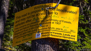
Fingers crossed that no progress had been made on the deactivation since my last visit!


Looks like another great trip! A couple suggestions...That "Purple Penstemon" is actually Fireweed. and I know that many people called those beautiful lilies Tiger Lilies, but they are actually Leopard Lilies. UJ
Alright! I love having a botanist to keep me honest! ? I've updated both, and I'm glad you're enjoying them as always. This trip gets better from here - stay tuned!
Thanks for another great story. I’m looking forward to the next installment.
On your Canadian trips do you come across the same relative numbers of abandoned cabins and mine as you do in your travels in the western US?
You're welcome - glad you enjoyed the story! I'd say that we come upon approximately the same number of structures as we do in other Pacific Northwest places (western WA, western OR, mountains of ID). That is to say, there aren't a ton of places - the weather here - especially the snow and spring rains - are hard on buildings. The deserts of the Southwest are where old mines, cabins, and buildings can survive for a long time.
I love British Colombia, lots and lots of water and great people that is very hospitable. I use to haul produce all over BC and Alberta. Always enjoyed my weekly trips, need to make a run back.
Thanks for sharing and bringing back good memories