
I love nearly every aspect of getting out to explore. The research when I'm at home. The anticipation of what will be found along the way. The unexpected discoveries along the journey. And, of course, the excitement of finding the destinations themselves.
Usually.
The Back Story
Even the best-laid plans - of which mine rarely qualify - run into a snag every now and then. Sometimes it takes multiple attempts to find what we are looking for - if we ever find it at all - as I learned in the case of a singular rock along the Pahranagat Trail over the course of 2023.
The secret - I've found - to turning these failures into success, is to hook up with people who are more knowledgeable than me. It's not hard to find these people - my pool of knowledge, while larger than it used to be, is still on the small side - but sometimes it's tricky to convince them that I have good intentions and won't give away the secret spots that they hold so dear. It's understandable in the days of InstaTube and the social interwebs, so I'm always grateful when I'm able to meet these good folks in person, giving them the chance to size me up and see that I'm just another guy who loves the same things they do.
And that's exactly what happened with JP. I'd discovered one of his trip reports, where he and his hiking companion, found a lone petroglyph in the remote wilderness of the Turtle Mountains. After hours of research - this is a little-known place - I reached out with the information I'd been able to piece together, hoping for confirmation that I was on the right track. Alas, having seen these types of places burned before, I could tell that my inquiry was viewed with a good deal of skepticism, and I got little in the way of reassurance.
Sure that we could find it for ourselves, @mrs.turbodb and I had a fantastic time searching, but ultimately came up empty. I reached out again - this time with the actual GPS track we'd personally hiked - hoping that my persistence and on-the-ground efforts would help to demonstrate my intentions.
JP started to warm up, but I could tell he still wasn't all the way there. "I only share data with people I know, so lemme know if you're ever out in the SE Mojave and we'll meet up."
After a few messages back and forth, he went on,
We'd be up for getting together sometime, but we won't be the ones who cause a sensitive site to be posted to the internet. TMI to follow...
Once upon a time, there was an internet personality who called himself Death Valley Jim. He became notorious for presenting the works of Guy Starbuck, the DzrtGrlz, and even ourselves as his own...
The biggest difference was that he was for profit and posted coordinates on his website. This caused us to stop posting for years. If it's in Joshua Tree, we have pics of it, but we'll likely never post them now...
This conversation is giving me flashbacks. I regret posting the trip ███████████████ but what's done is done. If you find it on your own, you may have your own internal dialogue about posting it. I won't influence it...
If you wanna get together, we'll be at our place from mid-December through mid-January. Shoot us a time and a place and we'll see if it can work.
That seemed promising, and I tucked it away in my back pocket, knowing that I'd want to meet JP regardless of whether I found the petroglyph on my own or not. And, knowing that I'd be in the immediate area as part of the Segment 4 of the East Mojave Heritage Trail, I thought there was still a chance that I could uncover the elusive art without any assistance.

After another gorgeous evening of searching, I still came up empty on the rock art. It was time to call in the big guns, and I reached out with the story of my second attempt and some firm dates in hand. The response I got was better than I could have ever imagined:
I should be around and up to no good the weekend of ████████. The adventure I'm planning is definitely way much for my other half...
The Blueprint Petroglyph is a marker along a native trail that leads SW away from the Mopah Range. We stumbled across it on our original visit in 2013 and followed it, finding the petroglyph en route, until we realized it was gonna keep going, most likely to either ████ or █████ Spring...
My idea is to return and follow the trail as long as practical, looping back via ██████ Spring at some point. The trail is invisible on Google Earth, so wingin' it is my only option. It's a near full-moon that night so it's the perfect day for something stupid...
If you're interested, we could meet at the trailhead for ██████ Spring, drive to the one for ██████ Spring, and wing it. Fair warning: the bees in my bonnet almost always cause me to be out well after sunset, but that's where the near-full moon comes in. It completely won't be the first time...
As for mileage, I'm sure I could do it in a day, but it'll be long. I estimate it at nominally at 8+ miles, but steps multiply when one's seeking rock art, especially along a native trail that could go miles in the wrong direction. Like most things in the Turtles. only one way to find out...
A smile crossed my face, and we penciled in the date. While I couldn't wait to find the petroglyph, more than anything, I found myself more excited to meet JP!
Into the Turtle Mountains
Having just wrapped up my first trip to Death Valley in more than a year, my route to the Turtle Mountain Wilderness scooted through Las Vegas. This was convenient, as it meant that I wouldn't need to cook dinner - there's In-n-Out for that - but more importantly - as I'd not brought any lunch fixings on my trip to Death Valley, opting instead for breakfast and an "early" dinner after my last hike of the day - it meant that I could pick up a Chipotle burrito to take with me on the 10-mile hike with JP.
I also took the opportunity to find an "only in Las Vegas" sight that I caught out of the corner of my eye on one of my early Uber-from-the-airport-rides to pick up the Tacoma. Ever since, I've wondered, "what the ...," every time I've driven by.

Initially, I thought it was an advertising gimmick for a soon-to-be-released movie, but it's been more than a year since my first sighting, so that's likely not the situation. I also assumed that it was on airport property - unviewable from anywhere but the freeway - but after a little looking on my handheld computer device, I thought there might be a way for me to get a little closer.


As I was snapping a few pics of one of the more iconic Autobots, I noticed another robot an a nearby street corner. This must be someone's hobby, because the level of detail on these things was fantastic. Really, so amaze.

After enjoying a bit of time marveling at a childhood-memory-brought-to-life, I headed south - through Arizona for some cheap fuel - and to a familiar location on the edge of the Turtle Mountain Wilderness. It was dark when I arrived, and after a long day, I was ready for bed.
Knowing that JP was arriving somewhere between 8:00 and 9:00am, I wasn't in any huge rush to get up - my usual sunrise descent from the tent making it easy for me to be ready to go once he showed up - and before long I was making my way to the trailhead for ██████ Spring.


I heard the Jeep before I saw it. Not knowing what type of vehicle JP would be arriving in, I decided it was a fitting ride for someone who enjoys the bumpy backroads and hard-to-access trailheads across the Colorado and Mojave deserts. After a quick round of hellos, and plentiful thanks for agreeing to this crazy excursion with me, we set about gathering our things before getting underway.
And - of course - most importantly for both of us - it seemed that neither of us was a random internet murderer.

Our things laid out, I don't know if it was JP's observation - along the lines of, "that's all the water you're going to need for eight miles?" - or his comment that he had "two days of food," that reinforced for me how much I really hate carrying things when I'm out hiking. While it does limit my ability to achieve extremely long distances by overnighting along the way, I've found that I'm so much more comfortable without a pack on my shoulders. And, except in the hottest of conditions, as long as I'm fueled up before leaving, 44oz of water and a single meal can generally get me through a full day of hiking.
With JP's plan to complete this hike under the light of the nearly full moon, I sure hoped that would be the case today!
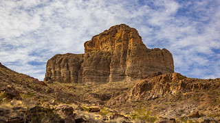

We had no idea how long our plan - to follow a native trail as long as we could - would keep us going, but for the first couple of miles, things progressed splendidly. Here, the route finding was easy - miners having supplemented the old native trails to enable easy retrieval of water - and our good clip was only slowed by JPs enthusiastic destruction of pointless cairns and frequent photo stops. I took great pleasure in both of these activities, each of them indicating that we shared a similar mindset out here in the wild.
JP would later share that some cairns - those along native trails - are perfectly acceptable, which was a surprise to me. Rarely travelled - but needing literal feet on the ground to survive - these markers are generally much less ornamental and further spaced than the "cairn forests" that frequent many heavily traveled routes.


Yellow Primrose (?) (left) | Orangemallow (right)

We'd end up following the cairns for the entirety of our loop. This surprised JP, and indicated to him that this wasn't a native trail but rather a very old mining route, used only rarely to lead burros to water or over the range. This also seemed to be supported by the fact that we didn't find much in the way of native rock art along the way - something that JP was hoping to find if this had been a native trail.

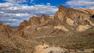
After a couple of miles, the lightly defined footpath disappeared into the landscape. Separating for a bit to search for the faint hints of those before us, we found nothing, opting instead to follow the natural undulations of the terrain for much of the remainder of our adventure. Along the way, we'd see a handful of cairns - that we happened to spot-but-not-follow - a reminder that deep down, there's some amount of instinct to route finding, even for us modern day techno-humans.


On hikes like this, it's important to look down as much as it is to look up. Wandering along - at a leisurely pace that kept us moving without tiring - we'd make frequent stops. Many of these were to admire some of the most rugged terrain in the Mojave, but several were also to revel at an especially nice bit of flora, or run our fingers over a bit of stone.


Chalcedony Roses - also sometimes called Agate Roses - are so-named because they can sometimes look like they have swirling petals. The flower-like growths formed when a hot silica gel of chalcedony composition, having a viscosity perhaps similar to that of toothpaste, was injected under pressure into the open cavity. Cool.


By the time lunch rolled around - sometime between noon and 1:00pm - we'd completed a little more than half of our loop, at least as measured on a map. The second half - with the steepest and trickiest terrain - would prove to be much slower going, but as we sat down to give our feet a rest and enjoy our provisions, we couldn't help but notice how cooperative the weather was being for our silly adventure. After two hot days hiking Death Valley, I was thankful for the ever-present breeze that was sweeping in from the west; JP mentioned that he forecast - for the last three days - had been for 30+ mph winds, so he too was glad for the gentler conditions. Plus - to this point - a high layer of clouds had kept us mostly out of the sun, while still breaking enough to allow stunningly bright views of the rugged terrain.
We spent the better part of an hour enjoying a rocky outcropping as I consumed my burrito and JP ate - what appeared to me to be - a charcuterie board of snack foods. This must be the unofficial lunch of champions - a secret smorgasbord I've never been introduced to - as I've seen many of my travelling buddies do the same thing. Still, my room temperature burrito was tasty and filling, a much more satisfying lunch than the trail mix, mandarins, and dry cereal I would have otherwise scrounged together from what little I had in the Tacoma.


The saddle was our last major unknown on a hike that'd been largely a mystery. While we'd need to navigate both the ascent and descent first, an old road - to ██████ Spring - was a route that JP and his wife had visited before, and would make the final two miles of our loop a straightforward affair. Assuming that is, that we could get there.
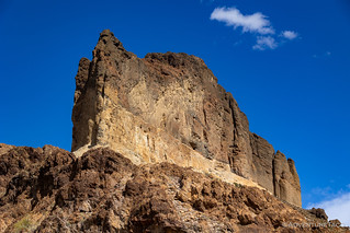

I had no idea what to expect as we crested the saddle. JP - surely familiar with the magic that lay beyond - wasn't spoiling anything. Our intermittent conversation - breaking equally pleasurable stretches of silence as we gazed up at the formations around us - jumping from topic to topic as we noted a once-again-defined foot path that traced its way through house-sized "meatball boulders" that littered the final quarter mile of the ascent.


Reaching the saddle, we'd completed just under seven miles and climbed the last of the 1700 feet that our route would require. We sat there - for 15 minutes or so - to admire.


Losing and regaining the trail as we headed into the basin, going was slow as tired knees absorbed the steepest terrain of the day, our shoes dislodging loose rock as we picked out way down.

Soon enough we reached the wash, and after a quick look at our electronic route finders to ensure that we knew when to search the shrubbery for the old mine road that would complete our loop, we picked up our pace for the final two miles of our trek.

It was 5:00pm on the dot - and we were back at the trucks - when JP slipped his feet into the flip-flops that he'd carried the entire day. I'd joked with him when I'd seen them tied to his bag as we departed, but he assured me that his favorite footwear was perfect for many desert treks. This one, unfortunately, was just a bit on the rocky side.
Stowing our things, talk turned - as it does when the end is near - to future adventures. Each of our lists - seeming to grow rather than shrink over time - were easy to rattle off. Thanks and handshakes were shared. JP climbed into his Jeep and headed for home. I contemplated finding a new spot to camp before heading home the following morning, but opted instead to stay put and enjoy the Turtle Mountains under a full moon.


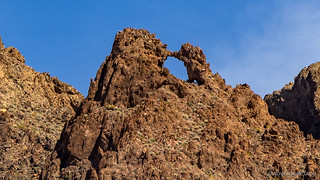
Finding the Blueprint Petroglyph
The Blueprint Petroglyph is a little-known rock art site between nothing and nowhere. Please help to keep it special by not sharing its location or photos that can be used to geolocate it.
While JP's goal in this outing had been to follow a native trail for as long as we could, I couldn't wait to finally find the rock art I'd spent several hours hunting for over the course of two previous visits. I'd picked up on a couple new clues between my last visit and this one, realizing the mistakes I'd made in my previous search area. Now reasonably confident that I knew where to find this lone rock in the middle of the nowhere, it was fun to find my "in this area" waypoint to be within about 15 feet of the actual stone.
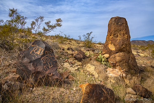

After finding the Blueprint Petroglyph, we canvased the area looking for more rock art. While we didn't find anything in the most promising locations, we did stumble on one more glyph looking up at the sky.


Adventures in the Turtle Mountains


Beautiful country and a nice hike, thanks for sharing. Too bad that Palo Verde wasn't blooming. I have a large Palo Verde Desert Museum in my front yard which has grown immensely since I planted it some years ago and it blooms several times a year, brilliant yellow flowers that the bees love!
Thanks John! I've only seen the Palo Verde blooming once (to my recollection), which was nearby - at the end of the EMHT - just west of Needles. The flowers were very small when I passed through, but they caught me off guard and I stopped to grab a photo (that I never posted in the story). I was surprised, because it was January -- too early, I would have thought.
Yes, the flowers are very small and yellow but when mine blooms the tree is covered. There are so many bees that you can hear the buzz coming from the front yard.
LOVE THE AUTOBOTS!!!
Right? Those were SO cool to find. Actually, I only spotted Bumblebee from the freeway, but then found the second one when I was wandering around trying to find a way to get up close and personal with Bumblebee.
Despite many internet searches, I still have no idea who created them, or why.