
The wind that had been relentless the day before died down over the next several hours, resulting in the most pleasant night of the trip. Oriented just so, there was no need to get up in the morning to enjoy the sunrise either - something I'm sure I'll forget by the next time we go out.

A full day ahead, we didn't linger long under the covers, both of us out of the tent by 6:30am - our long shadows playing across the playa, Steens Mountain towering to our west - so we could get breakfast eaten and the tent stowed by our planned departure time of 7:00am. After-all, we had 100 miles of dirt ahead of us...assuming we didn't get turned around somewhere along the route.


It was actually 7:15am by the time I finished taking photos and lollygagging on my tent-packing chores, and as we pulled off the Playa for the last time, we bid it farewell - the three nights we'd spent in the same place an anomaly for us, though one we'd enjoyed.
Our route today would take us first south to Fields - for more fuel - and then west to Hart Mountain National Antelope Wildlife Refuge, our last stop on this 5 day trip. But first, as we headed south, we couldn't resist the pull of a purple blanket that unfolded along the side of the road.

As it turned out, we had plenty of time - as we arrived in Fields for fuel, the crowd outside Fields Station was indicative of the 8:00am opening - five minutes after we pulled in. Guess I should have noticed that when we were there the day before. Sharp, ehh? 
Luckily we didn't have long to wait before topping off the tank and having a quick chat with some of the locals. Curious if we'd even be able to make it over the first pass, we were relieved to find out that not only was Domingo Pass open, but it was apparently "mostly dry" and "even drier on the west side."
Well, at least we knew that the first 15% of our route was open. We headed out. 
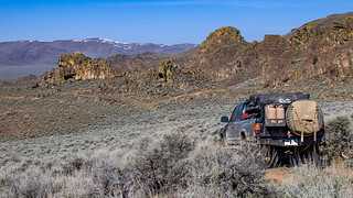
As we'd heard, the road was in reasonably good condition as we wound our way up Domingo Pass. A bit of water on the road here, a bit of snow on the hillside there, we completed the 2500' climb quickly - stopping only a few times to take in the expansive views and amazingly green lichen growing on the rocks near the summit.


From the top, the view was vast! The book that @mrs.turbodb had been reading talked about the Desert Trail (like the Pacific Crest Trail - PCT) that passed through these parts, where you could see for 50 miles in every direction. And that was no joke.
Only problem was, the views were a bit...monotonous. Green (right now) rolling hills as far as the eye could see.


It was right around here that I realized how - umm - how to put this... how crazy this plan was. I mean, really crazy. This wasn't like yesterday where we were eight miles from a ranch and three miles from the Alvord Playa if something went wrong. We could easily be 50 miles from the nearest help - two full days of hiking in the hot sun. Much more remote than even the OBDR trip that we did solo a couple of years ago.
Man, I must be getting old if I'm thinking about these things.
Anyway, we'd had cell service for most of the trip, but lost it on the way up Domingo Pass and I was sure that it'd be spotty as we headed into the nowhere of Oregon™. Here at the top though, the LTE was strong and I quickly whipped up an email to Pops that explained the crazy thing we were doing, and how long we expected it to take. And, since we were on roads that may or may not actually have existed, I sent along a GPS track as well.
I just hoped he knew how to open it! 
With that, we set off down the back side of the pass towards our next trail - Juniper Spring.
As was the case with most of the roads we'd been on this trip, it was clear that we were on a road that one would be generous to say was lightly traveled. My guess is that we were the first to drive it this year for sure, and that annual traffic could likely be counted on my fingers.
Elevation dropping as quickly as we'd climbed, we came to a rock outcropping that bore the remains of some long-forgotten rancher - a barb-wire rock one of the last remaining vestiges of human habitation. An anchor of some sort? Perhaps just a rancher with a weird sense of humor? A rock that tried to get away?

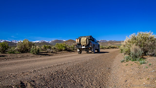
We soldiered on, making good time and leaving a trail of dust in our wake - the truck working fabulously at this point, taking us further and further into nowhere-ness. And then, water on the road.
But it wasn't bad - it was just a trickle really - a spring out here in the wilderness. And then I saw it - a singleton Juniper. I looked to my left and smiled. "We've reached Juniper Spring!" I announced smartly. And then, I wondered aloud, "What happens when the Juniper dies? Does it just become 'No Juniper spring'?" Dork.


From there, we covered a lot of ground - the remainder of Juniper Spring road, Ackley Camp Road, and half of Buckaroo Pass - all the while our eyes glued to the mountains ahead, the snow along their peaks causing us to wonder: could we make it?
Things were going well - the sun was warm, the air was sweet with spring, and the roads varied from good to great for covering ground. And it was reasonably dry - that is, until we reached a cattle reservoir that apparently was seasonal. I say apparently because the road drove right through the middle of the reservoir, and we weren't talking a few inches - we were talking a few feet. There was no way that we could make it work - and looking at the map, there was no immediately obvious re-route.
I got out and scouted the situation. It appeared that we could skirt the reservoir along it's lower edge - by driving over the dam - if we could make it onto the dam itself. See, the part of the dam nearest us had washed out.

Gun-shy from our experience the day before, I put on my Muck boots to see just how sketchy this was going to be.
To my surprise and relief, it was immediately obvious that the rockier soil here was going to provide plenty of support for the truck, as long as we stayed out of the reservoir proper. It took a bit of convincing, but eventually @mrs.turbodb also agreed that we might as well give it a try, and down we went. And up.
We'd done it! Looking back, it wasn't really that big a deal, but to us at the time - it was like getting back on your bike after falling off.

As we pulled away, smiles and "I can guarantee we're the first and only ones on the road this year" all around - in front of us, a beautiful pair of wild horses were doing the same thing we were - wandering around, looking for adventure. Curious about the world, they'd walk slowly towards us, then get spooked and canter away for a bit. Then mosey our way before galloping off to a safe distance. Downwind, we turned off the truck and watched for a bit, enjoying the curiosity we knew so well ourselves.

Eventually though, we knew we had to keep going - it was near lunch time and while we'd covered a lot of miles, we had no idea what was ahead. If we had to turn back now, we'd have a lot of "return" miles to cover before nightfall, the next day already fully accounted for by our drive home.
Another hour or so and we'd ticked off another 25 miles - we were now nearing Beatty's Butte and ultimately Flook Lake Road, the road that would take us into the Hart Mountain Refuge - and we decided that this was as good a place as any to enjoy the last of our lunch meat, chips, and apples. So, I got our chairs set up in the shade and @mrs.turbodb assembled sandwiches, and then we relaxed.

In even better spirits after filling our bellies, we once again sped off down the road - our confidence growing with every passing mile. Nearly 75 of those miles were behind us now, with another 25 to our final destination. As we sped along, we noticed a - shall we say interesting - dwelling (?) set back from the road. I mean, it was decked out with an exercise bike, a propane grill, and more - so it was clearly something that was occupied...but by who? And were they supposed to be there?
We were cool not finding out. I snapped a quick photo and carried on. As one does.

It was right around this point that we started getting cocky. Counting our chickens before they'd hatched. Birds in the bush. You know, that kind of thing. So it shouldn't be any sort of surprise that it wasn't long before we rounded a corner to find exactly what we'd been dreading for all these 85 miles...
Just like yesterday, a relatively shallow river that crossed the road. The red, dusty, not-very-rocky-at-this-point road.

It was Muck boot time, again. And this time - unlike the reservoir earlier in the day - it was less-obvious what the right answer was. It seemed to me that the bank was a muddy mess, but that once we got into the middle of the crossing, the traction wasn't bad. With nothing to winch off of, and only a wacko-in-a-shanty to ask for help, we probably should have turned back.
"We're going for it." I announced. "We can't be scared of all water crossings forever."
Famous last words... but not this time - we laid a few sage over the worse of the mud at the entrance to the crossing and locked all the lockers - and then walked the truck through like it was nothing. Whew.
Flush again with success, we quickly stumbled upon a bug-out shelter less than a mile up the road near Beatty's Butte. Constructed in 2008, this thing was insane - truly a zombie-apocalypse-style get-away, with concrete walls over 24" thick, and steel window and door coverings that weren't just locked, the locks were encased in boxes that had been welded over them - a cutting disk required to gain access.


A bit spooked, and also bummed that we couldn't check out the interior, we didn't spend long at the Oregon Zombie Defense site - instead pushing on towards our ultimate goal. We were soon rewarded by a sign that we didn't know existed, but that was a relief to us both.

We'd entered the refuge, and we were officially on Flook Lake Road. And - best of all - the "Road Closed" sign that we passed just a couple hundred feet further along was folded in half - the road was open!
That, or no one had ever come this way to close it at the end of the season last year. I joked to @mrs.turbodb that it would be funny if the the road went right through Flook Lake, but she pretty quickly set me straight by telling me that, "Flook Lake is over here." as she pointed at the map to show me how wrong I was.
...which I was OK with in this case, obviously.
The last few miles passed quickly at this point - we could taste victory. @mrs.turbodb even looked over and said, "Well, it was nice that one of the routes worked out!" And then we crested the last rise.
In front of us - we could clearly see - Flook Lake. And not just Flook Lake - we could also see our road disappear directly into the middle of the lake.
Flook me you flooking lake! 


We had two miles to go, and I turned to my right, "We're going to seriously consider driving across the tundra if there's no way around." i said. And I was serious.
Luckily for us, there was a faint way around - not to skirt the lake, I think - instead it was a route to some nearby petroglyphs that we didn't know about, unfortunately. But we didn't care - as one mile, then a mile-and-a-half, then nearly two miles ticked off, we realized we were going to make it.
And we'd done it in great time - it was not even 3:30pm and in front of us was Hart Mountain. Victory was ours! Sure, it was a route that we wouldn't have given a second thought to later in the year, but today - today we were heroes.
Even if it was just each others heroes.

A quick stop at the visitor center to use the flush toilet, and we decided that rather than go straight to the hot springs and campground, we'd first go check out Petroglyph Lake. We'd done enough research before heading out to know that the road to the lake was closed, but at only 2 miles each way, we figured it would be a good way to stretch our legs after a long day in the truck.

By the time we got to the lake, the joke I'd made at the trailhead of just driving around the flimsy gate was something we both wished we'd done - the road was boring and totally passable, likely closed simply because no one had checked it. Of course, we'd never have driven around the gate but it was fun to talk about doing it!
But what we were here for were the petroglyphs. Covering a quarter-mile long wall along the north edge of the lake, there are dozens of images etched into the rocks, and we had a great time discovering one after another.
The first few were reasonably basic.


But then things started to get more interesting. This dude was perhaps diving into the water? Or just really liked headstands?

And then, near the end, the coolest of them all - I thought. Bug-head-man, and his buddies. Or were they? Maybe they were his snack...running away.


Our curiosity satisfied, we returned to the truck and decided that before heading to the hot springs, we'd air up - we'd be heading out on reasonably maintained roads early the next morning and airing up away from the springs would be nicer for everyone trying to enjoy their quiet solitude.
That task completed, we were only minutes from camp, which we found a mere 50 feet from the hot spring - the campground basically empty on a Saturday night (to our surprise and delight).

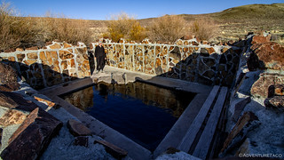
Our dip in the hot spring was great - just what was needed after a long day on the road - even if it was a little slimy for our tastes. Definitely cool though to be in a natural spring that's bubbling up around you and just the right depth to stand in, up to your neck.
Oh, and as the only ones there, we could enjoy it in our favorite suits of all - birthday suits!
Our soak complete, dinner was the next thing on our minds - lamb stew for me and some sort of rice pilaf thing for @mrs.turbodb - which we enjoyed as the sun set overhead, a purple hue tinting the sky above camp.

We called it a night shortly after - the sky still light as we climbed into the tent to read our books. I probably lasted a good 7 minutes or so before dozing off, @mrs.turbodb not much longer than that.
It had been a great day - a successful day - but just barely. Perhaps the best kind.
- - - - -
April 28, 2019.
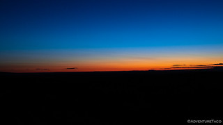
It was a cold night. 24°F when I awoke around 5:00am for sunrise. Having "thought ahead" and only brought a sweatshirt in the "sleeves" department, I put on every piece of clothing I could find - including @mrs.turbodb's jacket and gloves - and headed up the road and out of the campground to get a view of the horizon. I was just in time, the gentle wedge of Steens Mountain just poking up through the orange.

The tent still covered in ice, we put it away without breakfast, our plan to survive only on the meagerest of granola bars and apples until we could have an early lunch on the road. OK, that's not true - the Cherry and Dark Chocolate bars are amazing and who doesn't love a good Fuji apple?
We were out of the hot springs campground by 6:30am - our earliest morning by far, and a good time to catch it in the morning light.


Headed west and north, we almost immediately hit the aptly named Lake County, and then, we were out of the refuge.


All that remained was highway. We'd survived another adventure, and had a great time doing it.
You. Should. Too. 


April 27th
Once again, we woke up on the playa, got breakfasted, packed up and ready to go. This time, though, we were out early – a little after 7am – and it would be the last time, hopefully, of this trip. Unless, of course, something went wrong on Domingo pass.
First stop was an amazing field of purple flowers outside of the former largish town of Andrews (now just a set of ranches) on the south end of the playa. It was too perfect with Steens in the background. Pictures of the truck were taken and then back on the road to Fields.
We weren’t the only ones getting an early start in Fields. We arrived just before 8am and there was already a line, but fortunately, we were the only ones getting gas – everyone else was waiting for breakfast at the café/gas/grocery/motel all in one. The banter was about hunting, mostly small game like rabbits and squirrels. And of course, there was no small amount of scoping out the truck. There were also two birders, binoculars around their necks and on their eyes. Fields has a reputation for being a central meeting point for everyone, and this morning was no exception. When it came our turn to pay, I took the opportunity to confirm for myself what @turbodb had found out yesterday: “yeah, Domingo pass is open. We went over it with a cow trailer yesterday,” the clerk said while looking out at the truck. “It has been a winter since it was graded, but you’ll have no problem in that.” And once we were over, would there be mud? “Nothing like it is over here. It’s dry over there already.” Fingers crossed, we were on our way.
South of Fields, we found the yellow cattle grate and turned right and started to climb. The road up Domingo Pass into the Pueblo Mountains was easy going and well graded, just as she had said. Up we went, past a little cabin in the distance, a few cows, and very wide open spaces. Soon enough, we were at the top of Domingo pass, with views out toward the Alvord, Steens Mountain, and south toward Nevada. The vistas were expansive. At the top, the rock became a mixture of layers of shaley rock and very porous volcanic rock, all of it covered in a bright green lichen. We pressed on, the switchbacks giving the truck no trouble. Upon cresting the top, similarly expansive views were had on the other side – there were no signs of humanity for as far as we could see, other than the road itself.
We dropped down into a wide valley, hoping that we wouldn’t run into any mud as we crossed the plain. We then made a left turn and then a right over a cattle guard through an area called Dip Creek. Then it was up over a smaller pass (Robbers Roost) with similarly bright green lichen then to Juniper Spring.
At Juniper spring, there were spires and other cool rock formations, some carved by the wind. It was another reminder that if you don’t go on dirt roads every now and then, you miss a lot of cool stuff.
Throughout our travels in the area between Fields and Hart Mountain, the literal blank space on the map, I was surprised by how many well maintained dirt roads there were. We would be driving along in what I kept repeating as “now we are really in the middle of nowhere” when suddenly we’d drive through an intersection with a terrific dirt road. To this I say: thank you ranchers and BLM!
At Juniper spring there was a spring! And a gate. It was the first gate of the day, and it seemed apparent to me that not many people went through it very often – rusty and splinter inducing. There was a lone set of tire tracks that went to the gate and then back out which helped prove the point. We were having fun alone in the wilderness.
Next, we were on Ackley Camp Road, through another wide valley, this one dotted with wells and watering troughs. One could only imagine the heat in this valley in the summer. Fortunately, for us, it was turning out to be a gorgeous day.
Ahead of us, however, was a pass next to Acty Mountain. At the base of the mountain, were the remnants of a mining operation, (Ackley camp?), and as the road wound around the mountain, we could see snow. If the snow drift was across the road, we were done. Fortunately, the snow had receded just enough that just the passenger-side tires went over the remnants. Phew! So far luck had been on our side.
Once we were over the top of the pass, we were up on a high plateau, with more snow covered mountains in the distance. We prayed we wouldn’t get stuck in the snow in the Mahogany Mountains as we went through Buckaroo pass. Little did we know that water, not snow would be our next test.
After crossing the broad plateau, we almost missed our turn. It wasn’t clear where our road was, until we realized that it went up on the other side of a small but full reservoir. Hmm… We had a decision to make: were we going to try to reroute ourselves, give up and go home, or go for it across a dam opening and up onto the berm, continuing on the road? Muckboots on again, @turbodb took a look. He voted to go for it. He said it was rocks not mud, so I held my breath and we were across before I was blue in the face. Had we attempted this a week ago, @turbodb wouldn’t have taken out the muckboots and I wouldn’t have given it a second thought, but after yesterday’s fiasco, I was already starting to look for dried sage brush to use as traction. Of course, the route was nothing for the truck.
The road, was less wonderful than the previous trail had been, we being the absolute first people on the trail this season. In fact, after our little water crossing, there were two wild horses that looked at us as intently as we looked at them. It was as it they were thinking “how’d you get here?” After our mutual stare down, they ran off, then paused and decided to chase after us. They were very curious.
Our next pass was Buckaroo Pass (the names of these roads are great). As we did all along the route, we were always looking for a back up re-route road – just in case. If we made it over this pass through the Mahogany Mountains, we were feeling pretty confident that we were done with any chance of snow blocking our way, but we were far from out of the woods.
Of course, we made it up and there was no snow, just a reservoir at the top that we easily skirted – not even a gate. And then, a lone ATV. It was at this point that we realized we hadn’t seen another person yet, and still hadn’t – the ATV was parked, and had been for who knows how long. The owner was nowhere to be seen.
Upon making it to the intersection of Beatty’s Butte Road and Buckaroo Pass Road, we stopped to have lunch. We were making good time and had plenty of fuel, more than enough to go all the way back if we had to, even the same way. Time to relax in the noon day sun.
Soon enough, back on the road past Beatty’s Butte, and then onto the road that would take us into Hart Mountain: Flook Lake Road. We were on our way! And then, in the middle of nowhere, we passed a homeless encampment snuggled up against a bluff. At least, that was what it looked like to this pair of Seattlites: a series of dilapidated tents, a weber grill, a falling-down shed, and no people in site. Super weird and very desert appropriate.
Once again, we came upon a low spot in the road, which meant water. Muckboots on again, as was becoming a safe routine, and once again, we felt safe to cross.
Three and half miles further up the road, we passed another desert oddity of humanity: a bug out bunker. Someone had built a cinderblock bunker up on top of a hill, complete with steel covered windows, a modern well (which had been shot), and two steel tractor-trailer containers which were welded shut (we know, we tried to open them). There was even a shooting range. With no military markings, we drew our conclusions, private end-of-the-world prepper bungalow, and bugged out down the road.
Within a few minutes, we were at the entrance to the reserve. Woot! It was clearly a back entrance, but there was a sign with the name of the road, and the closed sign was closed, which meant that the road was open, right?! So on we went, on a more bumpy cobblestone road. We could see Warner Peak and therefore the entirety of Hart Mountain in front of us. We were golden. And then when we were just 3 miles from the main Hart Mountain-Frenchglen road…
Water. As in Flook @#$% Lake. The dry lake, except when it isn’t. This time, I was swearing. Fortunately, we hadn’t driven into it, and we weren’t even considering driving into it.
Turns out, there was an easy re-route the skirted just around the outside of the lake. We wouldn’t need to backtrack more than 20 feet. So many thoughts: 1) please don’t let us get stuck 2) please let this connect 3) Dang. We had been so close to doing the nearly impossible: following a route that we had planned. That never happens and here we were so close to getting it done.
In all my nervousness about going around Flook Lake, I forgot to stop and look for the petroglyphs that were right in the area of the re-route. Dang again. I’d even highlighted it in my book! Oh well, we’ll have to come back.
We made it. We got to the visitor’s center, and then decided to check out the road to the west down to Plush – it was clear and the view was spectacular. With some time to kill, we decided to hike to Petroglyph Lake, because… petroglyphs. Also: we needed a walk. The road was closed due to wet road conditions, so we walked and scoffed at the ridiculousness of the road being closed as we could totally have driven that if Flook Lake Road was open. But mostly it was good to get out and use our own two feet. The lake was pretty and the rim was covered in petroglyphs. The name was apt.
By the time we got back to the truck, we were tired. It was time to get to the hot springs, take a dip and have dinner, which is what we did. Because of the time of year, all of the campsites save one were flooded. We took the lone campsite. With no one around, we had the springs to ourselves, and they were primitive, even with a cool rock wall providing some protection. The spring was so deep I had to tread water (I am not the tallest individual) which seems rare at a hot springs. Relaxed and refreshed, we made dinner. We were asleep with the setting sun, even though the stars were undoubtedly amazing, we were too tired to look.
April 28th
Being on top of the mountain, the campground around the hot springs is cold, like freeze your tookus off cold. The temperature was in the high 20s, which seemed crazy given that it had been shorts and t-shirts weather on the drive up. I woke up to a knock on the tent. It was @turbodb. He was wearing my coat with the hood up, his I-only-wear-this-if-it-is-really-cold hat, and my gloves. He’d been up early for sunrise pics, and he was basically frozen. He wanted to go.
The night had been windy, and @turbodb had used the water jug to hold the tent ladder down, our now-standard protocol after getting the tent closed up on us while on our way to Death Valley earlier in the year. When I moved the jug into the truck, I could hear the ice sloshing around, it was that cold. We were packed in minutes and I got my coat back.
The drive back was uneventful and another beautiful day. The decent from Hart Mountain made it clear why Lake County has that name. There might be more lakes than people. We passed through the non-metropolis of Plush and then continued through the Oregon backcountry, passing the early parts of the OBDR trip from two summers ago. How far we had come from those early days! How much more we knew now than then! We also noticed that there was still a lot of Oregon left to explore. We’ll be back.
Hi, I enjoy your amazing journeys.
Here is a link to the bunker you saw on the Alvord to Hart Mountain trip April 2019. It sold in September 2023 for $500,000.
Bug Out Bunker Property - 1,400 Acres - Dark Skies Sanctuary
Toby
Thanks Toby, who knew someone would want to buy that place? One thing is for sure though - the inside of one of the containers looks a lot nicer than I expected!