
We lucked out with a windless night along our ridge on the eastern edge of the Clark Mountains. Hoping that out orientation would allow for some nice color at sunrise, I was up early to try and find the best angle from which to capture the splendor we were lucky enough to call home for a night.

Mike @Digiratus and Zane @Speedytech7 weren't far behind, and as I was wrapping up the morning photo session of their best-gen trucks, they were boiling water for coffee and beginning the process of packing up camp.
Our plan for the day was ambitious. We'd start - not far from camp - at the Coloseum Mine, make our way through the Kingston Range Wilderness, explore a couple of old mines and cabins along the old Tonopah and Tidewater rail grade, and then work our way back towards the Clark Mountains, to camp amongst the troglodyte village at the old Valley Wells Smelter site.
Turns out, given the road - or roadless, as we'd discover - conditions, it was too ambitious, but we were blissfully unaware of what lay ahead as we set out for the Coloseum Mine.

Worked for many decades, the most profitable years for this mine were 1987-1993 when more than $100 million in gold was blasted out of the pit. During this time, it produced nearly 7000 oz. of gold per month, moving over 800,000 tons of material per month to accomplish the task. The operation ran 24 hours a day, and produced more than all the Mojave Preserve's other historic mines combined!
Hiking the Mojave Desert
The last time I'd visited this mine, it'd been abandoned. Today, however, a few shipping containers dotted the upper level, and as we peered over the side we could just make out a couple of drilling rigs just above the water line. We wondered aloud if there was some possibility of the mine reopening, and if so, whether the mountain of tailing should be the first plan of attack. Easy pickings as it were.


While it might have been fun to wander down to the equipment, the place was well-signed against doing so - and anyway, we had placed to be - so after a few photos and a lot of "man, that's big," we were back in our Tacomas and headed down Yates Well Road.


For much of the descent - some 1,500 feet or so - there wasn't much of a view as we were primarily travelling in a wash. As we neared the bottom however - transitioning off of Yates Well Road - we got a glimpse of what we were in for as the trail continued north into the Kingston Range Wilderness.

Before long, we were speeding along a long-ago-paved section of road toward the Excelsior Mine, a colorful Kingston Peak dazzling in the distance. "That looks like a mountain that must be full of good stuff to mine," Zane mentioned over the CB radio. It's rare that Zane comments on the geology or views - though I'm sure he enjoys them plenty - so I figured a stop was in order so we could all capture the view in our own way.


After a couple dozen high-speed miles - enough that I was wondering if we'd make it even further along the route by the end of the day than I'd initially thought - we bailed off the pavement and back onto dirt, the route passing through one of the beefiest gates I've encountered as it began winding its way through Kingston Wash.


Following tire tracks in the wash - essentially a pick-your-own-adventure as the "road" is frequently obliterated in heavy rains - we did our best to stay on the main route, content in our knowledge that any route we chose would ultimately lead us to the same destination. Except it wasn't quite so easy - at least not at the speeds our Tacoma's could travel - because part way down, I had a pit stop I wanted to make.


Where is Blackdawg?
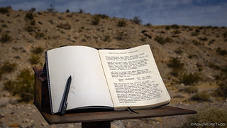
Now, it turns out that I'd missed the turn to the mailbox - by about 50 feet - as we'd barreled down the wash. I'd flipped around as soon as I realized my mistake, and mentioned over the radio to Mike and Zane that I was headed off along a side road in search of the mailbox. When they hadn't shown up by the time I was done signing the register, I simply followed the sideroad downstream until it rejoined the main route.


Once again we were three, and though I'd stopped several times to snap a photo of this or that along the way, we were still making very good time. Our false sense of security was growing strong!
It was 11:00am when we pulled into the parking area at Kingston Spring. With our daily schedule starting much earlier than normal for these trips, we'd eaten at about this time the previous morning, so I checked around to see if we should do the same today, mentioning, "The other option is that we wait half-an-hour or maybe forty-five minutes and eat at a couple of cabins that aren't too much further along the route."

With a sales pitch like that - and more likely, given that they'd both been snacking a bit already - it was no wonder that both Zane and Mike were keen to wait until we reached Riggs Cabin before breaking out the sandwhich fixings. Back in the trucks, we continued our trek to the west.
It was in the Valjean Valley that our descent down the alluvial fan was abruptly interrupted by a left-hand turn. The direction of this turn isn't all that important, only the fact that our travel was now across the alluvial fan matters. As @mrs.turbodb and I had learned when we were hiking Military Canyon in the Owlshead Mountains of Death Valley, cross-fan travel may seem like a shorter or more direct route, but it is never a good idea.
Years of rain - no doubt capped by the epic flooding from Hurricane Hillary a few months before our visit - made the 7 miles of "road" between our current location and Riggs Cabin an utter nightmare. Slowly crawling alongside old rail grade - the grade itself washed out in so many places as to be impassable as a means of travel - we found ourselves in 4-Lo as we climbed and fell through the 28-24" channels of rock and debris that scared the landscape.


It took us more than two hours to travel the seven miles between Valjean and Riggs Cabin. No longer was there a question of whether it was time for lunch, rather it was a question of whether we could prepare lunch before we starved to death. To death, I say.
Of course, I'm prone to risk all sorts of injury and apparently even death in situations like this, so while Mike and Zane pulled ingredients out of their fridges for hearty sandwiches, I headed into the cabin to check out the digs.


Then, it was time for a big old bowl of Wheat Chex - a cereal I bemoaned as a kid, but that is one of my favorites now - and some enormous, firm, red grapes as desert. I could tell that neither Zane nor Mike were jealous. 
Given the time of day, it was clear at this point that our slow traverse of the alluvial fan - an exercise we'd need to continue along the next segment of our route - meant that we were not going to make it to Valley Wells. Reevaluating the situation, I hoped we'd be able to make it to the Silver Lake Mine, a mere seven miles further along the trail and some 49 miles short of our original camping destination!
After a quick pow-wow regarding the new plan, I let the guys know that I was going to run over to an old mill site and workings just around the corner from the cabin, since we'd exerted quite a bit of effort to get here and I didn't want to leave without seeing as much as I could, even if we weren't going to do a multi-hour, full-site exploration.


Back on the road, there was only one stop - another cabin - between us and the Silver Lake Mine, and we had a choice to make as to our approach. The sure method - and the one we'd agreed to take as we'd reevaluated over lunch - was to head back the way we'd come, suffering through the alluvial fan a second time. The other option was to take a more direct route, following a road that was no longer visible on the ground at Riggs Cabin, but that - if we could find it along the way - would cut the distance by 75%.
We probably should have stuck with the original plan, but as I'd wandered up and around the hill to the mine, I thought I spotted a short section of the shorter road in the distance. Relaying that to the guys over the radio, and as the leader of this rag-tag bunch, I set off across the roughest terrain yet, hoping for the best.

We lost the road to Jake's Place about halfway between the EMHT and the cabin, instead following the wash - as apparently others had done before us - to a secondary approach to the cabin via a rickety flight of stairs leading from the wash, which have somehow survived the flooding events that pummeled everything else in sight.


Nicely kept place on the inside too. Very little evidence of rodent activity, no small feat in these parts!


With Mike having opted to stay with the trucks - his knee had been giving him some grief, and so a flight of rickety stairs wasn't something he wanted to tackle - Zane and I didn't spend long at Jake's place before heading back down to find our companion. He as a little way back down the wash, waiting for us - camera ready - at one of the obstacles we'd navigated on the way up. Hopefully he got a good shot or two!
And with that, we were on to the place we'd call home for the night. It was only 3:15pm, but getting to camp a little early was certainly better than arriving at our previously planned camp several hours after sunset. Plus, an early arrival would allow Mike an opportunity for a camp shower, and would also permit - for anyone interested - a more leisurely investigation of the structures and workings that I'd seen in satellite imagery as I'd planned the route through the Silver Lake Mine.


Once we found the road to the Silver Lake Mine, the going got quite a bit easier, though the terrain around it stayed the same. It's always surprising to me how much of an art road building can be, and the folks of the Silver Lake Mine had mastered their trade.


Approximately 7 miles northeast of the Silver Lake playa there are several old mine sites. The Silver Lake mine, first worked in 1916, is the oldest and largest operation. The other two mines have been operated continuously since the early 1940s. The combined output of the three totaled between 15,000 and 20,000 tons of talc in 1950.
Deposits of commercial talc in the vicinity of Silver Lake, were almost continuously mined from 1915 to the mid-1970s. They yielded an estimated 300,000 tons of metamorphosed sedimentary rocks. These deposits consist of mixtures of magnesian silicate minerals – mostly tremolite but also various proportions of talc, chlorite(?), serpentine, and forsterite. The products sold as commercial talc were used as a ceramic raw material and a paint ingredient. The talc-rich rock was also marketed as a lubricant in the manufacture of rubber goods.
academia.edu


After exploring what we could by truck, there was one thing nagging at me. The keen observer may have noticed it in a previous photo as well. At any rate, I knew I had to return for one more look.

Now, this adit had obviously been sealed up for what someone - likely someone who knew more than any of us - determined to be a good reason. And, as an upstanding citizen, I was in no position to bypass this elaborate barricade, even if said barricade contained an opening the perfect size for me to fold myself into.
So, I definitely didn't go in.
In fact, the following photos are - obviously, as anyone familiar with his LED-lit underground work will know - from Mike @mk5. I don't know when he visited, and he'd certainly never admit to remembering photographing this mine if he were asked, but I can confirm that the LED lights are his. I also have no idea how his photos ended up on my camera.
Just one of life's little mysteries, I guess.

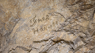
The adit extended quite a way into the mountain, several branches and shafts running in various directions in an effort to follow the highest grade material. Along the way, the names of many miners who once worked this mine were painted onto the wall with axle grease, the oldest from 1906!


With the sun only moments from dropping below the horizon, it was time to get back to camp. Surely by now, Mike and Zane would be ready to light the fire. Though, our elevation - 3,500 feet lower than the previous evening - meant that we'd likely keep the propane on low, using it mostly for the pleasant atmosphere it provided for "truck talk."

We'd end up chatting into the night, the moon rising and climbing high overhead before two of us couldn't take it anymore and excused ourselves for bed. As I'm prone to do, I'd found the highest spot around camp to call home for the night, so as I picked my way from the camp fire to my Tacoma, I found my mind wandering to the following day, and how far "behind schedule" today's roads had put us.
Because you know, when you're out here enjoying the desert, the "schedule" is the most important thing. Ha! That, and the knowledge that there were some amazing places in store for tomorrow, was enough to push any worry out of my mind, and before long, I drifted off to sleep.
The Whole Story


Looking for other segments of the EMHT? Check out
East Mojave Heritage Trail
for other trips where the other parts of this epic route were enjoyed.
I really enjoy your narrative and photos ! I’ve traversed the same route twice, first in 1990.
When I first visited Kingston spring, there was a rather large stone cabin nearby. It looked as though that was occupied very recently before our visit
As I recall there was a few furniture items as well as a Servel propane refrigerator on the front porch. A couple years later the house was gone with just a few rocks spread around the site.
Thanks Larry! It's always amazing to me how some parts of the desert change quickly (apparently, the cabin at Kingston Spring) and others change so slowly (generally, I suppose, places that are bit more off the beaten path). Such a dichotomy that makes me both want to "rush and see everything before it's gone," and also "slow down to enjoy the things I find in the desert."
Great report as always! Ahh yes, the Valjean crossing! I knew that Hilary totally blew that area up, so in early October 2023, I made a planned assault on Jake's from "below," coming up the power line road area from near Baker. Found tons of wash-outs and cross-alluvium challenges, but the tough part was the final ascent from the main trail to the cabin, a run I've made 4 times before. Needles to say, I had to re-con on foot for much of it, to find a way to make sense of what used to be the trail. Stacked a few rocks to make cairns. Yep, plowed over a basketball rock with my rear diff in the heat of battle as well. Thankfully, no harm other than a good chink in my armor. You probably read my entry in the cabin's log book. Cheers, PD
Thanks Paul! Definitely a rough route in out there at this point. We headed out to Baker on the powerline road, and it was orders of magnitude better than the T&T grade coming in from Valjean, likely because - by now - it's been more heavily travelled, since most (I think) start at Baker.
I probably did see your entry, though of all the cabins, this is the one I somehow forgot to take a photo of the final page... doh!
Many decades ago (1960's) we did some exploring around the Yates Well Road area but I don't remember what it was like or what we found but it wasn't the places you explored so it's nice to see what's out there now. I know that many of the mines and other places we explored back in the 1960's are most closed up, caved in, and just don't exist anymore.
There's lots of great stuff to explore up Yates Well Road. We've been up a few times before, and you may recognize some of the mines/cabins from our first trip, or the second, where we visited a bunch of the cabins/mines higher in the mountain. It was only a single winter between the two, but even in that short time, the Beatrice Cabin was a lot worse for wear! Those trips were a few years ago now, and you can even see (between the second trip and this one) that the Green Cabin is no longer standing upright. I'd guess that by next spring it won't be standing at all.
Out of all of your amazing adventures, this one really hits for me. You basically did the same trip I planned for this year. As a Midwesterner, this area coming out of Vegas on our road trip that I was totally blown away by, especially the area from Ivanpah over Mountain Pass until Baker. I had never seen anything like it before in my life. I even drove up 127 until I could find a dry lake bed to drive on a bit - totally out of the way but I had to lol. I went back 2 more times on trips and camped in the Silurian Hills which opened by eyes to the Sierras and all that area up the 395 to Reno. I really appreciate your work. I know it is enjoyment for you to go on these trips but we love the effort to share your journey.
Thanks so much Robbie, glad to hear you enjoyed and that you've had the chance to experience the area! I know I always like reading how others experienced the same places I've been, so I imagine it's the same for you! The Mojave Desert is an amazing place as you've begun to discover. Venture into Death Valley, and further south into the Colorado Desert and you'll continue to be blowwn away!