
I don't know if it was the coldest night of the trip from an absolute perspective, but when I climbed out of my tent, it was the only morning I found the rainfly - and the cab of the Tacoma - covered in a layer of frost. Luckily, as the final full day of our trip, we'd decided that no matter where we were, it was where we were going to cook our shared breakfast.
And that meant we'd have a couple extra hours for our tents to defrost.


Wandering back into camp, I found my companions awake, coffee in hand, and - to my surprise - standing around the propane fire pit to keep warm until the sun finally climbed high enough in the sky to bathe our camp in its rays. Once it did, we each retreated to our respective kitchens, and before long, a piping hot breakfast of bacon, eggs, and potatoes was spread on Zane's tailgate.


We wrapped up breakfast a little after 9:00am. Later than we'd been getting out of camp, but early enough that I was pretty sure we could get ourselves to the Mojave Megaphone by the time we needed to be in camp for the night. Of course, I'd been wrong every other day of the trip so far, so my certainty was worth as much as the bacon we had left over from breakfast.
Oh, right, there was no leftover bacon.

With the sun behind us, we made our way to our first stop of the day: the site of the Evening Star Mine. This old copper mine has one of the nicest headframes in the Mojave National Preserve (that I've encountered), and I hoped my buddies would like it as well.

The Evening Star Mine had slow beginnings. Its four claims covered a mineralized skarn near the contact between limestone and Jurassic granitic rocks (possibly Striped Mountain Pluton). Tire skarn had a host of metals, but few in sufficient quantities, and it eluded two generations of miners. Sometime between 1900 and 1910 a 740-foot exploratory shaft was sunk on the Rex claim in search of copper. Chalcopyrite was encountered, but showings were poor and no ore was produced. The Evening Star Mine was not revived until years later when tin was discovered, allegedly by John "Riley" Bembry in 1936. A war veteran then in his mid thirties, Bembry had just moved to the Mojave Desert and bought the Evening Star Mine in 1935. Following his tin strike, Bembry sold the mine, and the new owners started tin mining in 1938. Operations were again unsuccessful, and over the next two years the Evening Star Mine changed ownership and operator several times. But there was a lucky one, an Angelino named W. W. Hartman who worked the Bernice claim not for tin but for tungsten. In 1939 and 1940, he shipped 1,000 tons of tungsten ore from a single tunnel - which was not bad for a little mine.
In August 1940 new explorations uncovered an area rich in cassiterite (tin oxide) and instilled new hopes. The Steel Service and Sales Company of Chicago leased the mine and finally made it work. The ore was initially mined from an open cut and a shaft, then from a second shaft in 1943. Crushers installed on the main shaft's 60-foot headframe ground the ore, then the tin and copper ore were separated from waste rock by screening. In 1942 the company shipped 25 tons containing 6% tin by truck to Cima, then by rail to a Texas smelter. To process its ore locally, company owner Carl Wendrick put up a 30-ton mill at Windmill Station, at the north end of Cima Road. From then on the classified ore was trucked to his mill, where it was cleaned and further concentrated. It was a modest operation - eight people worked at the mine and four at the mill - but it did honorably well. Until 1944, 400 tons of classified tin ore were processed at the mill.
In 1944 long-hole drilling at the bottom of shaft No. 2 failed to encounter new ore, and tin mining stopped. A vertical shaft was sunk on a nearby copper vein in 1949, and Hartman's tungsten tunnel was extended to 340 feet in 1951-1952, but no ore was shipped. In the end, the Evening Star Mine did have one good claim to fame - it was the only tin producer in the east Mojave Desert.

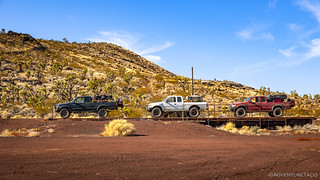
After chatting with a few folks who we found wandering around the Evening Star Mine - fellow explorers whose association with the NPS (that we never learned the details of) allowed them use of the Valley View Ranch overnight - we were once again on our way - headed south towards the cinder cones and the Cima Cinder Mine.

Three quarters of the way there, Mike piped up on the CB radio and asked if we could stop for a few minutes to review the route for the day - just to be sure that he understood where we might end up, and what route we'd each take the following morning when we split up for our respective trips home. That was just fine by me, and we happened to be passing an old ranch (Rock Tank?), so we pulled into the parking area and fired up the technology for a quick review. Then, it was off to check out the structures.


Routes for the rest of the day - I didn't have the heart to tell Mike we might not make it as far as I hoped - and the following day reviewed, we covered the final few miles to the Cima Cinder Mine in a matter of minutes, and soon we were parked on the flattest surface we could find.

Located in 1948 by Emerson and Fay Ray, the Cima Cinder Mine was a successful family-owned operation. Its only known production of 130,000 tons between 1954 and 1961 likely reflects a mere fraction of its total output.
The life of this mine ended on a very sad note. It was still running in 1994 when this area became a national preserve. Soon after, a coalition of environmental groups threatened to file a lawsuit against the NFS unless the mine was shut down. A main concern was the endangered desert tortoise, which the coalition claimed was threatened by mining activities. To forestall the lawsuit, in August 1999 the NFS evicted the owners, after 50 years of operation - for trespassing...


It was 11:55am when we pulled out of the Cima Cinder Mine, but more importantly, it was time for a route decision: the road to the left would take us to the Aiken Cinder Mine, while the road to the right - and a bit of a hike - might allow us to find another set of petroglyphs that I'd never seen before.
Thank goodness for good friends who are willing to put up with my crap - both of them opted for the rock art route, and Mike even seemed willing to give the hike a try!


After completing the three-quarter mile roundtrip to the petroglyphs, it was a little after noon when we got back to our trucks. Having enjoyed the largest meal of our trip only a couple hours earlier, I helpfully - in the not-helpful-at-all sense - suggested that it was time for lunch, if anyone was hungry. 
No one was. At least, I don't think eye rolls and groans mean, "feed me."
Continuing south, we were now in the heart of cinder cone country. Composed of about 40 cinder cones - 100 feet to more than 560 feet tall - most have erupted lava. This has resulted in a complex mosaic of more than 60 lava beds of different ages, compositions, and morphologies that span three periods of volcanism. The earliest started 7.6 million years ago and lasted, off and on, 1.1 million years. The second period - the most intense - occurred from 4.5 to 3.6 million years ago, in the northern half of the field. The third period began about one million years ago, in the southern portion of the field, lasting until 10,000 BC, with lava draining westward, toward Soda Lake.

In addition to the cinder cones, a relatively well-known lava tube graces these parts, and while I've visited several times on previous trips - always getting what I thought were reasonably nice photos - I've never been in the tube at the perfect time of day to capture the beam of sunlight that pours through the tube's sky lights. This time, I hoped, would change all that.

Turns out that even at 1:18pm, we were a bit early. This surprised me, as I thought I'd heard that noon(ish) was the optimal time to visit. Of course, it very well might be, at other times of year! Regardless, I was quite happy with the composition and Zane got a nice chuckle as well, as he watched me hopping up and down toward the beam of light, freezing in place as the camera clicked away.
By this point, I was cautiously optimistic that we'd actually achieve all the mileage I'd hoped to cover when we'd left camp after breakfast. I'd largely travelled the next sections of trail - though never on the same trip - and knew that while they were always presented in such a way as to instill the fear of death in those who dared venture through such remote sandy places as this, that they were - in actuality - both beautiful and fun. We were on our way through the Devil's Playground to an icon of the desert - the Mojave Megaphone.


After descending Rocky Ridge, we followed the power lines to Devil's Playground. Embedded deep in the preserve, the Devils Playground is the third largest dune complex in the country spanning nearly 30 miles between Kelso Dunes and Soda Lake. Distances here are deceiving - and hiking through the fine sand is not easy - a fact @mrs.turbodb and I discovered on our previous visit.


Aired down, equipped with 4WD, and with plenty of skinny pedal, we made it through Devil's Playground in a matter of minutes and picked up the power line road on the western edge of the dune field. We'd follow this road for another 30 miles or so, skirting the northern edge of the Bristol Mountains and racing across the dry, extremely dusty, playa of Crucero Lake.

Some peculiar cabins exist out in this remote corner (it's not a corner at all) of the Mojave, but we had places to be - camp - on this particular afternoon, so I could only describe the elusive Mojave Jackalope to my companions as we sped by the shed that I knew it called home.


We rolled up on the Mojave Megaphone just before 4:00pm. This was a spot that Mike had been keen to see - having heard of through several different sources. And, while he was glad to see it, I could tell he was a little bummed that it was perched so high above the desert floor, since his knee was bothering him a bit after our earlier trek of the day.


After spending a few minutes at the top, it was time to find camp. I'd already sent Mike to a nearby location that - while not the most beautiful - would certainly be functional for our final night in the desert. We rolled in, just a few minutes before sunset, and nestled ourselves in amongst the trees, hoping to shelter our tents from any breeze that might pick up overnight.

Zane and Mike both had long, 16+ hour drives in front of them the following day, so after a quick dinner and a short campfire, we agreed on 7:00am as our target departure time, and climbed into our tents to get a bit of shut eye. Five days had passed in what seemed like only two.
The following morning...

We were out of camp a few minutes after sunrise, and well before our 7:00am target. Now with LTE service, Google Maps guided us towards I-15, along a route I was nearly certain did not exist.
For once, I was right.
Luckily, having visited these parts a fair number of times, I knew where I was and more importantly, how to get where we were going, fast. Speeding along the Union Pacific rail grade, I'm sure we travelled at least as fast as the minivan that showed me up along this route last time.


After making sure our Tacomas were in pavement mode - and with hugs, handshakes, and reminders to text when we got where we were going complete - we all set off at different speeds toward home.
The Whole Story


Looking for other segments of the EMHT? Check out
East Mojave Heritage Trail
for other trips where the other parts of this epic route were enjoyed.
Wow, great trip. I think about those men who laid the rail lines in that area. You know that had to be some tough times.
The men who did all the work in the desert (and mountains, and west in general) back in the day had to have it hard. Those were the days when a "day of work" really meant something. And the women too. It was a work ethic that would be hard to imagine these days!
Glad you enjoyed the trip as always. Of course, we didn't finish the EMHT (as you know) on this trip, so there's more coming soon! 😉
Hello,
Looks like you had a great Mojave adventure. Where did you got the photo of the Jackalope? I’m curious because I’m the owner of the cabin.
Hey Charlie, The adventure was a great one - and they always seem to be - it's such a fantastic place to explore. That photo of the Jackalope was one that wasn't from this particular trip - as I mentioned in the story, I could only describe it to my buddies. I actually got that shot back in December of 2020 on our first visit to the Megaphone. There are a few more pics in that report, along with our journey to/from.
It's a nice place you've got out there, and it seems to have faired well in the last three years. Kudos on it! I'm curious how much time out get to spend out there, as it seems like there are a few other private parcels but none are as well organized as yours.
Hello Mr. Taco,
Thanks for the fast reply! I've been exploring and camping in the Mojave for the past 25 years and it never gets old. I first discovered the 'Jackalope Cabin' site in 2008. The original owner (John) bought the property in the mid 90's with the intent of building a remote Fly-In destination for adventurous pilots. John hosted an annual Fly-In every year since 2007, and I started assisting with it a few years later. John's interest eventually shifted to other endeavors, and I acquired the 40 acre property in November 2021. I have continued the annual Fly-In tradition, and last October was the 17th annual event. I get out there (by plane or 4WD) every few weeks and continue to make improvements while enjoying the peacefulness of the great Mojave. Maybe our paths will cross one day.
Mojave Ho!
I have to say, I’m always amazed when I post a story and someone closely related to a place I found in the desert contacts me. It is - for me - one of the most enjoyable contacts I have with folks, because I always love the personal connection and stories - like the background you shared with me on your place - that come from such conversations.
When we were through there in 2020, we noted the runway on the edge of the lakebed, and of course, when we drove past a month ago, we came in over the lakebed. Boy, it was dusty this time... or perhaps we didn’t really adventure across it the first time to find out it was dusty then! Super cool that you continue the fly-in tradition, and I love to hear that you’re out there on a regular basis.
I’m sure I’ll be by in the future, and now I’ll be looking forward to driving by, searching for a plane or vehicle that might suggest you’re there and I could stop in and say hello! Likewise, if you’re out enjoying some other slice of the desert and see an old green Tacoma with a plate cover that says AdventureTaco, please do chase me down and introduce yourself.
Cheers,
Dan