After cleaning up after dinner and getting the tent deployed, it was still only 6:15pm, too early - even for us - to hit the sack for the night. It was, rather, the perfect time for me to be reminded of what we had in store for the morning; the trail description I'd neglected to re-read prior to planning the trek.
Whipping out what we lovingly refer to as the Mojave Preserve bible - @mrs.turbodb was happy to oblige:
From its head near the highest point in the Granite Mountains to its mouth, Budweiser Canyon climbs about 2,800 feet in 2.5 miles. This is two thirds as much elevation change as the Bright Angel Trail in the Grand Canyon, in only 30% the distance. Come here to indulge in a memorable trek into this remarkable world of slickrock, boulders, high falls, and cliffs irrigated by a seasonal stream.
The lower canyon.
As soon as you enter Budweiser Canyon you know you are in for a major treat. From its mouth just below the spring the upper canyon is exposed in all its grandeur, a wide amphitheater of tall, steep slopes capped by the crest of the Granite Mountains, just over two air miles away but more than half a mile higher.
The initially sandy wash that pushes its way into this awesome basin is fairly open at first. But it is not long before the canyon shows its true nature. A creek flows through the lower canyon, intermittently above ground some of the year, and it is creating a serious problem for hikers. The lower wash is clogged with water-loving shrubs, including plenty of less-than-cuddly blackbrush and catclaw. The sides of the wash are generally no help: they are often walled in or overrun by impenetrable mesquite groves. Progress is slow. You find yourself constantly bushwhacking or stepping right over the plants and bouncing along two feet above firm ground you cannot see.
The upper canyon.
By the time you reach Triple Fall you have gained all of 380 feet of elevation. From here on up, Budweiser Canyon means business, and getting through takes a major workout. The least painful way to circumvent Triple Fall is up the draw on the east side 40 yards below it, guarded by a small forest of mesquite.
This last stretch is a good preview of the upper canyon: nasty brush in the washes, and a deluge of boulders a bit everywhere. The main canyon gets steeper and tougher with elevation. Many falls and boulder jams interrupt its course. Monster Fall, half way to the crest, is a towering cascade of monzogranite grooved by erosion. One of the highest in the preserve, it is a befitting gauge of the dimensions and majesty of this canyon.
Progress is so persistently tedious that it becomes laughable - here you are, with scraped legs and arms, puffing up an intractable landscape, snagged by catclaws, poked by tree limbs, a cholla stem hitchhiking on your shoe, enjoying the healing power of nature. The rare stretches of open ground inspire ecstasy. In washes or on ridges, a great deal of time is spent scrambling and scouting. Along the last half a mile to the crest, the ground is too steep - in excess of 50% - to hold a pinyon pine upright.
Well, that sounded ...scary. Having allocated - in my head - five-and-a-half hours to do the entire hike, I knew it wouldn't be enough. "Maybe we should just go explore Sheep Corral ," I suggested, since it was a nearby wonderland of rocks we'd not visited on our previous trips.
I could see the edges of @mrs.turbodb's mouth turn up at that suggestion, but ultimately that decision would have to wait till morning. For now, it was time for teeth brushing and a bit of shut eye. After a couple photos, of course.
Rising above the lights of Las Vegas, the Milky Way was putting on a show.So. Many. Stars.
The following morning...
If we were going to hike Budweiser Canyon and still have time to finish what we were really here to do - running Segment 3 of the EMHT - we were going to need to get an early start. Even that was unlikely to be enough, frankly. Still, in situations like this - where I'm faced with a series of impossibilities given the time constraints - I'm liable to suggest that we do everything, which is exactly what I suggested to my companion as we lay under the covers enjoying the pre-sunrise show in the sky.
Taking its cue from nearby Vegas, the sky was at it 24 hours a day!
"Why don't you make sandwiches for lunch while I look for the pictographs," I started, before adding, "Then we can hike up the canyon a way, and check out Sheep Corral on our way out."
C'mon man, what are you doing?! Seriously, even as I said it, I knew I was proposing a full day - or more - of activity. Something was going to have to give, but I was unwilling to give it. Not yet, anyway. And @mrs-turbodb - ever the trooper - just looked at me and smiled as she got started making the sandwiches. I wasn't fooling her. She knows how to tell time.
Before long, she'd wrapped up the sandwiches - literally, I suppose - and I knew that my chances of ever finding the pictographs were quickly fading. If we stood any sort of chance at accomplishing the hike and getting to Sheep Corral - again, let me be clear that we didn't stand any chance - we were going to need to go.
So, that's what we did.
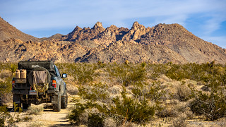
Two of these little hummers were getting a good look at us as we began our climb.
Everything about Digonnet's description turned out to be correct. The wonderland of granite was spectacular, boulders cascading down the mountainside, a varied desert flora exuding a sense of purposeful planting. And yet, our progress was slow - catclaw, blackbrush, and endless greenery blocking the wash; cholla, barrel cactus, and yucca hindering movement a bit higher. Still, in those moments where we raised our eyes from the few feet in front of us, splendor reigned.
Reading the description again, in the middle of this granite wonderland.This awesome tafoni was a joy to behold.At the top of a slickrock fall, a tub, worn deep over time.
We made surprisingly good time - better than either of us could have predicted - through lower Budweiser Canyon. With no trail to be found, routing was tedious but fun; surprises presenting themselves on a regular basis. We stopped frequently - not to catch our breath, but to admire that which we'd stumbled upon as we worked our way towards the top.
Nestled into the boulders, this Hedgehog(?) Cactus looked as happy as could be.Strikingly deep blue Canterbury Bells. (Phacelia campanularia ssp vasiformis)A dainty purple, waiting to be pollinated. (Hydrophyllaceae Phacelia crenulata?)
Just before 9:00am, we reached Triple Fall. While we were on no pace to reach the top of the canyon - we'd only gained 400- of the 2,800-feet to the top, we'd covered the mile of ground with significantly less effort - and significantly more enjoyment - than we'd readied ourselves for upon setting out. Now, the question was - should we continue?
Why bypass a fall that can result in certain death when you can climb it?
(Don't worry Mom, I returned to the bottom after the photo )
We waffled for a few minutes after my "climb" up Triple Fall. The bypass looked easy enough - and @mrs.turbodb even started up as I contemplated the time - but ultimately, we decided that we'd never be able to finish the hike on this particular trip.
With the smart money on saving the hike for a future adventure, @mrs.turbodb started back down the wash. I, on the other hand, couldn't leave well enough alone. Calling back to her that I would catch up, I continued to climb - leaping from rock to rock as I increased my pace - to see what the upper canyon had to show.
As I crested the bypass at Triple Fall, there was still a long way to go to the top.Monster Fall was intimidating, even from a distance.#worthit
Satisfied - or as satisfied that I could be knowing that it would be an all-day effort to get to the top - I retraced my steps, finally catching up with my hiking partner only a few hundred feet before we reached the mouth of the canyon. Big smiles covered both our faces - it'd been one of our most enjoyable hikes in the Preserve.
Plus, since it was still early - only 10:00am - we had "plenty" of time to check out Sheep Corral . You know, because once something has been suggested, it becomes a required part of the adventure. Seriously, says so right here .
From one wonderland of rocks to another.
Unlike most canyons - where material erodes from the surrounding hillsides and flows out the canyon mouth as an alluvial fan - Sheep Corral is carved down into an alluvial fan. As such, it's nearly invisible as one is approaching, the ground-level perspective making it seem as though the fan simply continues along the base of the Granite Mountains below which Sheep Corral sits. It's only as one enters this stealth labyrinth - sunken 100 feet beneath the surface of the fan - that the true beauty of this place is revealed.
Boulder hall.Into the maze.Which way should we go?
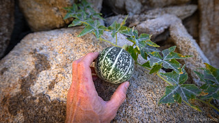
As with Budweiser Canyon, the boulders were the highlight, but they weren't the only game in town. Nestled here and there life was abundant in this harsh landscape, juniper and Coyote Melon vying for our limited attention.
My own personalized watermelon?Thank goodness there were no roadrunners and coyotes around here at the moment.View from the top, looking west.Much to explore.
We returned to the Tacoma - and the sandwiches that'd been prepared as I searched futilely for the pictographs - a few minutes after noon. Hungry after two vigorous trek-climbs, we wasted no time in demolishing the tasty treats, a few Fritos, water, and perhaps a Duet Bite, rounding out our meal. And then, we finally made our way back to the EMHT, for the first time today!
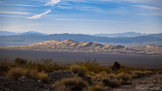
After cresting Granite Pass, Kelso Dunes peaked out from behind a yucca garden.The trail turned momentarily toward the Providence Mountains, a view too good to pass up.Getting closer.
Rising 500 feet above their surroundings, the Kelso Dunes are the second tallest in the California Desert, surpassed only by Eureka Valley's mighty dunes. While we wouldn't be climbing their highest summit today, this is - understandably - the preserve's most popular hiking destination. Covering about 45 square miles, the Kelso Dunes form the southern end of Devil's Playground, and offer near endless possibilities for enjoying the magic world of sand.
It was the wandering into this world that we were unsure about. We've done it before, and given the dunes popularity, it takes some serious doing to get to a point where no other prints mar the surface and plants don't fill the frame. Today, there was no time for such a slog - hiking in the sand is always harder than we think - but we weren't satisfied with a simple drive by, either.
I always love finding these grass circles.With a little creative positioning, it almost looks like we made it halfway.
Even our mini-hike of the Kelso Dunes took us an hour given the speed with which we were able to plod through the fine, soft, sand. So, by the time we were headed into the Providence Mountains - and still more than 20 miles of trail in front of us, not to mention the mines we planned to explore - we had less than two hours of sunlight remaining. Once again, the winter race was on.
Hurricane Hillary had not been kind to the road to the Vulcan Mine.Behind us, late afternoon sun added amazing depth to the Kelso Dunes.
First discovered in 1902, the Vulcan Mine remained largely untouched for four decades. But it rose to stardom with a vengeance.
The first prominent figure in the mine's history was Charles Colcock Jones, a mining engineer from Los Angeles who first visited the property in the spring of 1906 while on a professional trip in the area. Well experienced in iron deposits, Jones quickly realized the Vulcan's outstanding commercial value. Two years later, he secured rights to it with five patented claims. Over the next few years, Jones repeatedly called attention to the fact that some 200 million tons of high-grade iron ore were waiting to be exploited, opening a few cuts and a 100-foot tunnel to expose the formation and confirm its economic value.
Final approach.
Jones' strategy paid off. Around the late 1930s, he sold his claims to Henry John Kaiser - the same Henry Kaiser who, a few years later, would cofound for his employees one of the country's first health maintenance organizations, Kaiser Permanente. Kaiser needed steel for the mass production of commercial and military ships at his West Coast shipyards - World War II was raging, and heavy metals were in high demand worldwide. Kaiser had already erected a huge steel smelter in Fontana, near San Bernardino, and to fuel his plant he proceeded to buy all the iron deposits he could lay his hands on. The Vulcan was up for sale, so it was the first to be exploited.
The Vulcan Mine had two major assets. First, based on bore holes and a tunnel that passed through nearly half a mile of ore, Kaiser knew he was sitting on at least six million tons of ore. Second, it was backed by a competent and financially secure organization. So, unlike most desert mines, the Vulcan Mine was developed in style. Between December 1942 and July 1947, a team of about 100 explosives experts, shovel operators, truck drivers, foremen, and engineers proceeded to excise this huge iron blister from the side of the mountain. To match the Fontana smelter capacity, about 2,500 tons of ore were shipped every day - a heap the size of a one-story house. Until 1943, the ore was removed from a wide staircase-like quarry 130 feet tall. The ore was blasted with dynamite, shoveled into trucks, then hauled to an onsite jaw crusher. The average blast ripped up some 30,000 tons of ore, but it took nearly two weeks to grind and ship this much ore.
After the above-ground portion of the deposit was exhausted, mining proceeded downward into an open pit that traced the oblong contour of the deposit. The pit was excavated in a succession of 50-foot benches over the course of several years.
Follow the money.There was a lot more water in the pit the last time we visited.
By 1944, the pit was three benches deep. In July 1947, the miners had cleaned out the fifth bench. Less than 50% of the ore had been extracted, but further work would require more costly underground mining. Kaiser had also acquired a huge iron deposit in Riverside County, much closer to his Fontana smelter, called Eagle Mountain, its estimated reserve a whopping 60 million tons. Kaiser moved its operations there, and the Vulcan Mine shut down.
High on the hillside, the foundations of the old crusher still watch over the site.
In less than five years, the Vulcan Mine had produced 2.64 million tons of ore, nearly doubling California's production, and grossed over $2.5 million. Jones' old dream had come true: California was well on its way to becoming a major steel producer.Hiking the Mojave Desert
After a quick exploration of the Vulcan Mine, we were ready to tackle a road - up and over the Providence Mountains - that'd beaten us on our last attempt to reach the other side.
By now, it was clear - even to me - that we weren't going to make it to the end of Segment 3 by the time we needed to find camp for the night. This area - along the southern flank of the Providence Mountains - is unique along the EMHT in that there are three out-and-back segments before ultimately ending up in Fenner for fuel and the beginning of Segment 4.
We weren't going to do all the legs. The first - Mitchell Caverns - was one that we'd visited less than a year earlier. With limited spaces and generally booked months in advance, we'd lucked out when we showed up at 9:00am and walked on to the 11:00am tour. And the last - Hole in the Wall - was a place we've not only visited, but also camped and hiked several times in our explorations of the Mojave Preserve. That left only the middle out-and-back - an old mining road to the Bonanza King mine, Silver King mine, and ghost town of Providence - another spot we've been, but a place that we knew had plenty more for us to see.
Up and over the Providence Mountains, we conquered the gas line road!
(It was easy when it wasn't covered in snow. )Follow the yellow-dust-road.
Much of the road to Providence and the Bonanza King Mine is shared with the nearby ranch, and as such is well graded. However, the last few miles - after the final fork - more than make up for the pleasant experience, the road covered in football sized rocks, seemingly placed loosen every filling in a human mouth. As such, it was just as the sun was dropping below the horizon that we found ourselves at the Bonanza King, a race against light for a few shadowless photos.
The collapse mill of the Bonanza King.While most of the old buildings of Providence have been reduced to nothing more than stone foundations, a few quarried-stone houses have aged a little more gracefully.The last time we'd visited, we hadn't even noticed the swiss-cheesing of the mountainside behind the mill.Tempting, but we walked it instead.Little mouse was not happy to have us in his mine, and kept running away from his nest - full of baby little mice - every time we shined our light on him.Apparently, the "normal" camp site for EMHT explorers.I don't know why, but I always enjoy seeing the wood stoves in these cabins.
As usual, we didn't have enough time to see everything, but with light running out, it was time to find camp. There were a few options: the cabin-with-a-stove seemed like an obvious one, but there were also the quarried walls or even the top of the waste platform at the old mill. In fact, the latter was perfect except for one minor detail - less than 25 feet away, the main shaft of the Bonanza King plunged 600 feet strait down.
Obviously, given my tendency to always favor "a spot on the edge," we chose the waste pile and set about deploying camp and making dinner.
Seems ...safe?
By the time we climbed into bed - the sky dark, but our clocks informing us that it was only slightly after 7:00pm - we were pooped. Though it'd been a day of revisiting places we'd seen before, it'd been nice to get a little further into each one, unravelling a few more seemingly endless layers of exploration that the desert affords.
We'd do a bit more of that in the morning before heading to Fenner, and then enjoy a little more excitement on the way home!
Another inspiring adventure, THANK YOU! Having more than years of hiking, climbing, backpacking, and mine exploration I would be the first to say I could do that Budweiser Canyon hike and probably the first to die trying, LOL. The places you mentioned are why we spent so much time exploring the desert (and still do), so many places and things to see. In the spring we plan to visit the Kelso area, mostly on the better roads and skirting the others to visit Tecopa and other places. As for Kaiser Steel, I remember, as a child, going through Fontana and the Kaiser Plant. We'd leave home in L.A. to visit relatives in Oklahoma, traveling in the evening to avoid the desert heat. In Fontana there was heavy smoke and the smell and glow of the steel mill, it seemed like Hell was purported to be!
turbodbJanuary 22, 2024
Glad you enjoyed it, John! I've not been to Tecopa yet, but I hear it's a fun place to visit now - the new (?) owner has done a bunch of work, and is running tours. A couple of my buddies have gone, and one has been multiple times. Just a matter of time for me, I hope!
Tom StokerJanuary 22, 2024
Wow, I LOVE the very descriptive, well-written narrative, and the gorgeous photos!
Thank You!!
A born-and-bred Idahoan (I know southern and central Idaho like the back of my hand after 65+ years of exploration) this area seems like another planet to me!
I so enjoy this fabulous tour you share here!!
turbodbJanuary 22, 2024
Thanks so much Tom, always puts a smile on my face when folks enjoy the stories enough to let me know about it! Hopefully you've had a chance to read some more of my desert adventures, but if not, a great place to start is with the full East Mojave Heritage Trail (that this story you commented on was a chapter of), or many of my trips to Death Valley.
But, don't stop there! Your home state is one of my favorite. There are a bunch of trips into Idaho, and for the first time last year I did a dedicated trip to the Idaho Owyhees (I've been through before, and done trip to the Idaho Owyhees, but never focused on the Idaho side). WOW!
And of course, to give you one final link - you can get all the stories (as I post them) in your inbox. I hate spam, so you'll only get stories, and you can always click a link to stop receiving them - https://adventuretaco.com/subscribe/
Thanks again for leaving a note, and sorry to bombard you!


 )
)


 .
.


Another inspiring adventure, THANK YOU! Having more than years of hiking, climbing, backpacking, and mine exploration I would be the first to say I could do that Budweiser Canyon hike and probably the first to die trying, LOL. The places you mentioned are why we spent so much time exploring the desert (and still do), so many places and things to see. In the spring we plan to visit the Kelso area, mostly on the better roads and skirting the others to visit Tecopa and other places. As for Kaiser Steel, I remember, as a child, going through Fontana and the Kaiser Plant. We'd leave home in L.A. to visit relatives in Oklahoma, traveling in the evening to avoid the desert heat. In Fontana there was heavy smoke and the smell and glow of the steel mill, it seemed like Hell was purported to be!
Glad you enjoyed it, John! I've not been to Tecopa yet, but I hear it's a fun place to visit now - the new (?) owner has done a bunch of work, and is running tours. A couple of my buddies have gone, and one has been multiple times. Just a matter of time for me, I hope!
Wow, I LOVE the very descriptive, well-written narrative, and the gorgeous photos!
Thank You!!
A born-and-bred Idahoan (I know southern and central Idaho like the back of my hand after 65+ years of exploration) this area seems like another planet to me!
I so enjoy this fabulous tour you share here!!
Thanks so much Tom, always puts a smile on my face when folks enjoy the stories enough to let me know about it! Hopefully you've had a chance to read some more of my desert adventures, but if not, a great place to start is with the full East Mojave Heritage Trail (that this story you commented on was a chapter of), or many of my trips to Death Valley.
But, don't stop there! Your home state is one of my favorite. There are a bunch of trips into Idaho, and for the first time last year I did a dedicated trip to the Idaho Owyhees (I've been through before, and done trip to the Idaho Owyhees, but never focused on the Idaho side). WOW!
And of course, to give you one final link - you can get all the stories (as I post them) in your inbox. I hate spam, so you'll only get stories, and you can always click a link to stop receiving them - https://adventuretaco.com/subscribe/
Thanks again for leaving a note, and sorry to bombard you!