
Camped at 2,250 feet above sea level, the entirety of the night was quite a bit warmer than the previous two evenings at more than 5,500 feet, and it was so nice to open up all the windows and doors on the tent so that whenever I'd wake up through the night, I can take a quick glance at the surroundings and admire them under the moonlight.

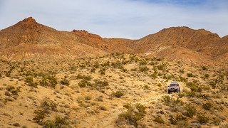
After three days of doing it, getting out of camp early was now a habit, so after making a quick cup of coffee and stuffing tents into their covers, we were on the trail and determined to make up some of the time we'd lost crossing the alluvial fans the previous afternoon.

There aren't a lot of places to fuel up in this part of the world, and we'd covered some 160 miles since our thank-goodness-we-got-Mike's-truck-fixed stop in Searchlight, so as we rolled into Baker, his light was on and the supercharged Redhead was hungry for a high-octane breakfast. Zane - despite getting significantly better gas mileage - decided to fill up as well, while I opted to avoid the $6.49/gal bill and rely on the 18 gallons - essentially a full tank - I was carrying in my Scepter jerry cans.
So, while they filled up and also looked for propane refills, I popped over to the old motel to admire some of the graffiti.

The motel was crazy. The rooms - all forced open and trashed to various degrees - had been fully appointed when they were abandoned. Not knowing the history, it was a little sad to see how fellow humans had simply destroyed this building that belonged to someone else. Sad, but I suppose not all that surprising.
From the motel, I made a quick stop at the Baker Market for a dozen eggs - Mike @Digiratus having brought potatoes, and Zane @Speedytech7, bacon - so we could enjoy a group breakfast the following morning. And then, I found an empty parking lot and waited for my buddies to find me.

Mike - eventually finding a place to refill his water - rolled in a bit later, and after a final stop on the edge of town for propane, we were on our way east toward the Hollow Hills Wilderness and Turquoise Mountain.


Pushing further north, there were a couple of places that I'd been anticipating since pulling together the route and waypoints that we'd try to visit on our whirlwind tour. The first of these was a "crack" in the crust of the earth at the Wanderer Mine; the other was a turquoise mine high on a hillside. The turquoise mine was especially intriguing as I've never visited such a mine in the past, and because I had a hunch that it was probably the one that Ken @DVExile visited in fall 2022, but that I'd been left wondering as to its location.
Not everything I find on satellite is interesting, and the crack at the Wanderer Mine was exceedingly lame. Sure, it was a trench dug by miners, but it was neither all that deep nor all that long. I took a photo, but it was so underwhelming that I'm certainly not showing it to you, and I'm not even sure I kept it for my own collection.


We continued to make good time as we neared Turquoise Mountain, and after finding the turn towards the ██████, we soon found ourselves climbing the flanks of a colorful giant.


From 1890-1910, the “Great American Turquoise Rush” was on. The “Rush” was given a boost when George Kunz, a special agent for the U.S. Geological Survey, and perhaps more importantly, a Vice-President of world-renowned Tiffany’s, declared - in 1892 - that turquoise mined in the Baker, California area was equal to, or perhaps even superior to, Persian turquoise which to that point had been the world standard. Needless to say, Kunz’s comments stirred an even greater interest in turquoise found in the region. (Tiffany’s was so enamored of turquoise that it became the foundation of the company’s iconic blue box.) It is this legacy which has established the Pacific region as perhaps the finest source of turquoise today.
Miner James Hyten established a claim on Turquoise Mountain in 1896, naming it the Gem (later known as Stone Hammer for the primitive mining tools found there.) Hyten ultimately sold his interest to the Himalaya Mining Company in 1900. By the end of the year, the company would ship $28,000 (more than $400,000 in 2018 dollars) in turquoise to New York. Six years later the mine was sold to the ██████ Mining Company. The company also operated the ██████ Turquoise Mine which displayed numerous signs of prehistoric mining and which had given the mountain its name.

With the approach steep and loose, Mike opted to hang out with the trucks while Zane and I headed into the adits in search of some blue-green ore that we could bring back to our buddy. Soon though, we were distracted by the swiss-cheese style mining, with more than a half-dozen adits and a maze of tunnels that often intersected each other or accessed stopes from various directions. It really was insane inside this mountain.


Through it all, we found very little turquoise. I suppose this shouldn't come as much of a surprise - I've never found a big-ole-nugget at a gold mine, either - but we did find a couple very small turquoise veins, and something a bit ... larger.


Not wanting to leave Mike for too long, we headed back to the Tacomas with the turquoise and did a bit of show-and-tell before firing up the engines and heading back down the hill, our sites set on Valley Wells - the spot I'd planned to camp the previous night!


The smelter at Valley Wells was constructed in 1898 to process ore from the Copper World Mine. As was often the case, the two operations had a symbiotic relationship. Smelters were vital to copper mines, like mills were to gold mines, because they separated the metal from the host rock and greatly reduced shipping costs. The mine supplied the ore that the smelter needed to run, the smelter processed it, and the sale of the copper brought cash to both.
In the simplest implementation of smelting, a carbon-rich fuel like coal is covered with ore and fired up. The combustion is hot enough to melt the ore. When the ore is an oxide, the carbon removes oxygen from it to form carbon dioxide and reduces the oxide to metal. The denser liquid metal sinks to the bottom, while the unwanted fraction, the slag, rises to the surface. After cooling, the vitreous slag is broken off and discarded, leaving behind concentrated copper.
At Valley Wells the ore was first crushed, then ground in a ball mill. Sulfur oxide obtained by roasting pyrite was passed through the ground ore. The ore was washed to get a solution of copper and iron sulfates, which was reduced with iron cans in concrete tanks to precipitate the metal. The resulting copper-iron cake was finally smelted.
Valley Wells operated during the Copper World Mine's first and third periods of activity, from 1899 to early 1904 and from November 1917 through 1918. The coal came from New Mexico, and pyrite from the mines in the Providence Mountains.
Valley Wells had a bit of a town too. Its small population of smelter operators and mule skinners was easily exceeded by the mules that did all the hauling. The town even had a post office, which was moved from the dying town of Ivanpah in April 1899, but lasted only a few more months in Valley Wells, before closing in July 1900.


The "town" at Valley Wells consisted of troglodytic dugouts to combat the sweltering summer temperatures.

After wandering around for half an hour or so, we'd completed our exploration of Valley Wells, and we climbed back into our trucks to head east towards the Copper World Mine - from which the vast majority of its copper ore had originated - in the southern folds of the Clark Mountains.
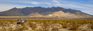

A few minutes later - after picking our way through a quarter mile of virtually roadless wash - we arrived at the base of the Copper World Mine.
The last time I'd visited, I'd parked at the bottom and walked an overgrown mine road the last eighth mile, only discovering a drivable road as @mrs.turbodb hiked back down. Of course, that'd been more than four years earlier, and my memory hasn't gotten any better in that time, so we proceeded to repeat the same error - in exactly the same way - this time around.


Having explored the last bit of the Clark Mountains that we'd planned for this adventure, it was finally time to head into the heart of the Mojave National Preserve. From here, our route would take us through the Ivanpah Mountains and then across the Kelso Basin - where I'd hoped to find a low-elevation camp for the night - but given that we only had 90 minutes of daylight remaining, that was clearly out of the question.
I pushed that fact out of my mind as we raced against the sun, hoping that we'd be able to make it to a series of cabins in the Ivanpah Mountains before my cohorts got grumpy about our arrival time.


From the overlook at 5,336 feet - where 15mph winds dropped the already cold temperatures to levels I can only refer to as "unpleasant" - our road entered a wash as it began its descent. At that point - and after the fall floods - the road was no longer. With the possible exception of our cross-alluvial-fan traverse the previous afternoon, this was by far the roughest section of trail on our trip.
Our Tacomas - easily up to the task - spit us out into the valley 20 minutes later, the western-facing slopes awash in a blanket of gold.


It was 4:53pm when we started up the drive to the cabin where I'd hoped to camp. "Ruh roh," I announced over the CB radio, "someone else is already here!"
It wasn't that big a deal, really, since I knew of another - perhaps even nicer - cabin not far away. So, after a quick chat with the occupant - it his first time visiting the cabin - we made the quick jaunt back down the drive and less than a mile further to the hard-to-call-it-a-backup option.

I have organized this story a bit differently than most.
Some of the locations have little or no reporting on the internet and I feel they should remain that way or someone I respect has personally requested that I not share them; as such, locations have been redacted and/or not mentioned, I've used non-official names for local landmarks, and the order of the trip has been randomized.
Please, if you know the locations shown here, I encourage you to enjoy them as much as I did - and follow my lead by not mentioning their names or locations in order to keep them a little less well-known, and special.
For more on my approach, you can read Do you have a GPX for that?.
In this particular case, please consider this request I found posted inside the █████████████████████. This is why I've redacted the names, and I'd request that you do the same.


Somehow, I always end up here at same time of day. Previously, @mrs.turbodb and I were racing to catch sunset at a nearby mine, so I hadn't gotten a chance to look around at all. This time - even a little later in the day - I felt rushed again, the dark interior of the cabin making it hard to see what I was looking at. Still, I did find a fantastic history of the cabin, and a very intriguing letter that I was able to read and capture - a real treat, since so many of these places are a complete mystery.
And then, it was back to camp, where Mike and Zane were already setting up their tents and just finalizing setup of the propane fire ring that would do its best - though, mostly failing - to keep us warm into the chilly night.

The highlight of the evening - which, like so many others, consisted of adventure and truck talk, along with a healthy dose of staring into the flames and rotating our bodies to stay warm - was when Mike offered to make dinner for all three of us. Mike's burritos - like his salsa - are famous, and without hesitation, there was a unanimous chorus of "yes, please," when the offer was made.
Without a doubt, it was the best dinner of the trip, and despite having plenty to eat, I don't think any of us would have complained if we'd been forced to eat another round or two of the tasty rolled treats!
The next day would be our last. And it would be full of firsts for all of us!
The Whole Story


Looking for other segments of the EMHT? Check out
East Mojave Heritage Trail
for other trips where the other parts of this epic route were enjoyed.
Once again, beautiful pictures of this segment of the trail.
I see the last cabin you visited has had lots of improvements over the past few years.
When we first visited the cabin, it wasn’t long after the old miner had passed on. There was an outside pantry that still had canned and glass jars of food and his mineral lab still had many tools and ore scattered about.
Thanks Larry, glad you enjoyed the story and photos!
That cabin has had a lot of TLC, and has several folks who spend significant time keeping it (and other nearby cabins) in tip-top shape as far as desert places go! (And, in the case of these, with the blessing of the NPS, which is rather rare.)
The outside pantry is gone, but the mineral lab is still standing (albeit without the tools). Recently the old pickup was moved to Goffs, hopefully to be "safer" from those who show up without the best manners.
"If you care, don't share" is the code of the Mojave, indeed.
As far as burying the transmission lines - it would be extremely difficult and costly to put this kind of infrastructure underground. If were done, there would be a long line of scarred earth left in its wake. There are dozens of these heading into the LA Basin. Ugly, but at least they make a good visual marker if one loses their way.
YES, burying power lines have some serious technical challenges and, of course, the biggest is COST! Ah, the first job I was offered in 1970, fresh out of the Army was at a AT&T MW site called Turquoise! Yep, out there not too far from the big thermometer in Baker. I knew it well since a friend and I had explored the area back in the 1960's & had found some small deposits of turquoise. It was in the middle of nowhere so AT&T built housing in Yermo for techs working the radio site. Eventually it was automated and operated remotely from our center in Los Angeles, when repair/maintenance was required techs were sent in a helicopter to service the remote sites.
Yeah, the scar on the land is definitely there, but as you mention, this is done all the time for fiber, gas piplelines, etc. IMO (and I know admittedly very little), it seems like there's a lot less maintenance of these buried lines, for a similar amount of land scaring (above ground lines always have a powerline road anyway!
What a lot of people don't think about, it that power transmission generates a lot of heat in the lines. Burying power lines requires that a cooling system be installed, which would use a lot of power.
Really? So when I live in a neighborhood with underground power, there is a cooling system along with all the wires? I'm super curious how that works.
And is it power only? What about fiber for data transmission - does that need cooling as well, or no, because it's fiber vs. copper/metal.
I don't know the details. Long distance transmission would be different than local, as the voltage is higher. I doubt fiber needs it, as that is light and not electricity. It's the electrical resistance of the cable that generates the heat.
I remember reading about some local transmission lines going in where a section was buried near a town, and the cooling that was needed there.
One of my fave portions of Segment 2. Especially the wonderful Joshua Tree section that you passed through after the Copper World Mine. Nice.
Yes, that little section there through the Clark Mountains was fantastic! Always nice to find those little spots. Always puts a smile on my face when a story brings back good memories for someone, please don't hesitate to mention it in the future as well!
Also, if you've not explored the Alaska Hills area, I think you'll like it! 😉