
April 25, 2019.
It'd been several weeks since my last trip and as usual that meant I had a bad case of the shakes. Spring is such a frustrating time from an adventure perspective - the weather seems so nice, and yet everywhere interesting is still covered in snow. And, the winter staple - the desert - is getting hot.
You can imagine my delight when a check of the weather showed that the Alvord Desert - a place we'd visited for the first time last October - was going to have weather in the mid-70's. From my perspective, we hadn't spent nearly enough time there exploring the roads; from @mrs.turbodb's point of view: we'd skipped all of the hot springs!
The horror, I know.
We got a late start due to life getting in the way and arrived at the Alvord Playa in southeast Oregon just after 10:00pm. We found the perfect (random) spot two miles from the edge and with no need to level the truck, we quickly got setup - ready for some of the great sleep afforded by our Exped Megamat Duo and for what the next day would bring.
From the get-go, it didn't disappoint. Not by a long shot.


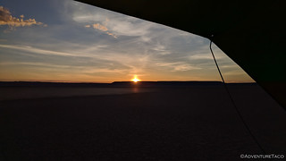
I poked around outside the truck for a few minutes, but it wasn't long before I climbed back in - the warmth and snuggles too alluring to keep me on the playa for an extended period. Plus - a secret that only early-risers know - there are two sunrises on the best mornings. There's that orange glow on the horizon that signals the continued existence of the sun, and then an hour later, the actual sunrise!
And there, now I've let the secret out of the bag.
While only I got to enjoy the first sunrise of the morning, we both soaked in the second - initially from the comfort of the tent, but shortly after, we were up and about, getting ready for what we thought would be a reasonably relaxed day.


As the sun rose to the east, "we" got breakfast ready to go, where "we" included me eating the Honey Bunches of Oats with Almonds topped with fresh strawberries.  To our west, Steens Mountain - still covered in snow - rose a mile above us, a reminder that this wouldn't be our last trip to the area - the highest road in Oregon on our list of places to visit.

While breakfast was prepared, I escaped the title of complete slouch by putting away the tent and breaking down camp. And with our amazing divide-and-conquer teamwork, we were ready to roll out of camp by 8:42am. We had some learning to do when it came to the definition of "relaxed day."
Our first destination was due east another 3 miles on the far side of the Alvord Playa: Big Sand Gap.

I don't know if anyone actually remembers the last time we visited, but one of the most remarkable things about the Playa is the surreal experience you get when driving on it at high speed. It's so flat, and so vast, that objects in the distance appear stationary while the ground around the truck is flying by. The only reaction I've ever seen to this phenomenon is a big-old-smile, and that's what happened this time as well, as dust kicked up behind us, hanging in the still air - a Taco contrail.


To @mrs.turbodb's delight, we both took turns making dust before turning east again - Steens Mountain rising up behind us.

The Alvord Playa is among the largest playas in all of Oregon. Formed when rain water falls, fills shallow depressions in the landscape, and then evaporates, this flat basin is a called a graben - a basin down-dropped by faulting around it. In this case, it's approximately 8 miles east-west and 70 miles north-south - though the "drive-it-like-you-stole-it" lake bed is really more like 5-by-10 miles - and marks the easternmost border of Oregon's Basin and Range, which is slowly extending westward. This movement, due to active faulting in the Alvord Desert has uplifted and tilted the surrounding ranges - Steens Mountain, etc. - leaving any water that enters the Alvord Playa to escape only via evaporation.
Our goal for the morning was to head to the eastern edge - to Big Sand Gap - where 13,000-14,000 years ago the water burst through the lake's rim and sent some 40,000 cubic yards per second of water down the drainage of Crooked Creek and into the Owyhee River, dramatically lowering the lake level.

We found a spot to park next to some horse hitching posts near the edge of the Playa and headed off, another two miles of flat sandy ground to cover before we reached the gap. Of course, to us it looked like a half-mile or so - distances in this desert, like Death Valley, messing with our internal range finders.

As has been the case on several trips so far this year, we hit this one at just the right time to get a completely unnatural experience - green. It was spring in the desert and not only was there green grass in place of the normally golden grass on the surrounding hills, but there were wildflowers bursting out of every hole.
Some of them fragrant. In a good way, not like my feet.


We made quick work of the two miles as we followed wild horse trails to the gap, stopping now and then to empty the fine sand out of our shoes.


To our surprise, the first thing we noticed upon our arrival was a road. I'd done quite a bit of research prior to the trip on the various roads around the Playa, and there were several that we were planning on exploring over the course of the next couple days. But nowhere had I found this road.
We ignored my oversight like you might a second-favorite-child, and added it to our list for the next day as we headed up the southern cliff to get a view of where we'd been.

It was a great one, and we enjoyed it - albeit gingerly, the rocks top of the cliff literally teetering on the edge of what was quite clearly an active fault.

As we climbed around, several species of lizard kept us company. This was even more exciting for me than the view, because I'm strange. I've always been fascinated by lizards, catching them every chance I get. It goes over really well with anyone who isn't squeamish about lizards - and especially @mini.turbodb, so that's good.
First, we saw a pretty-standard-nothing-to-really-get-all-excited-about but larger-than-normal blue belly lizard. Technically a Western Fence Lizard, though this guy was far from the nearest fence. Oh, and it scared the begeezus out of @mrs.turbodb as it scurried out from under her feet.

Next was the coolest lizard - a Desert Horned Lizard. I've never seen one of these in the wild before, so when I noticed it, I can only describe it as being like a kid in a lizard store - pretty pumped.
Others may say easily entertained.

Finally, as we were heading down - actually, I think I was bringing up the rear at this point - I noticed this guy out of the corner of my eye. It was huge - close to 15-inches long, I initially thought it might be an alligator lizard, but unlike any I'd seen before.
Turns out no, it was a Great Basin Collard Lizard. As if anyone but me cares, right? 

OK, enough about lizards - I know that no one is here for that. We headed back to the truck and decided that our next order of business should be to drive back to Big Sand Gap. That's what any good American would do - it's American Hiking™.
So, with a bit of driving along the edge of the Playa, we found the road and bombed our way up to the gap to take in the view. Our plan was to eat lunch there as well, but there were swarms of mosquitoes that put the kibosh on that idea quickly.

But, we were hungry and we'd been here just an hour earlier, so we figured a good next step would be to find a place to eat lunch - perhaps across the Playa at the Alvord Hot Springs - a place that @mrs.turbodb was determined to visit this time, having skipped it on our first trip last year. Only a few miles away, we were making great time across the Playa until I slammed on the brakes.
Just in the nick of time I'd noticed - or we'd noticed - I don't really know who noticed, water on the Playa. Driving into that could have been a trip-ending disaster - the mud easily reaching depths of 18" or more. The water seemed to extend all the way to the hot springs, once again stymieing plans for a dip - OK by me at that point, since who really wants to get in some hot water under the blazing mid-day sun.
Instead, we found ourselves a nice little private spot in the middle of the Playa and I setup the tent (for some shade) as a delicious lunch of turkey-salami sandwiches was made out of the ARB fridge - still one of the best things I think we've ever bought for adventuring.

Lunch devoured, we did what only the most intelligent would do - we looked up above us and saw a deployed tent and a warm afternoon. Time for a nap! This was the life. We were actually doing it. We were having a reasonably relaxed day.
Well, for 90 minutes anyway. That's when we were awoken by a couple guys on bicycles who were riding around the truck in circles, trying to figure out what the tent was. Not that it says "Cascadia Vehicle Tent" on it anywhere.
Except on every side. 
Roused from our nap and unable to contain our reasonable relaxation, we decided we'd get a jump on the next day's adventures and go explore the northern portion of the Alvord Desert. We'd gotten a quick look at this the last time we'd passed through, but there were a couple things we really wanted to explore:
- Crippled Horse Spring - we'd driven by Mickey Basin as we were looking for a way out last time, but running short on time and fuel we weren't able to look around.
- The East Entrance to Alvord Playa - I'd found a road that theoretically entered the Playa at the northeast. Seemed like a fun adventure if we could find it.
On our way to Crippled Horse Spring, we made a quick pit stop at Mickey Hot Springs - too hot to take a dip at 180°F, there are some amazing colors, bubbling mud, and even the occasional geyser here - a worthy hour of discovery if you haven't been before.


We'd seen this the last time though, and with another couple already there enjoying the solitude, we pushed on - excited for what we were sure was a much larger hot spring in Crippled Horse Spring. See, the last time we'd been through, we'd seen a huge cloud of steam rising from the playa. It was so large that at first we thought it was someone driving - or doing donuts - on the dusty ground, but as we got closer, there were no vehicles.
This time, we parked the truck as close as we could to what little steam we could see and headed out on foot. It was going to be great.

Distances were once again deceiving and we had a mile or so to go before we got to the location of the steam. Except that when we got there, all we found was dried mud. Cool looking for sure, but not the spectacular pool of bubbling water that we'd worked ourselves up over.

Sure that we'd simply missed it, we each explored in our own directions for a few minutes until... nothing. What the heck was going on? Were we crazy? (don't answer that!)
And then, as the wind whipped across the dry lake bed, we knew we'd been had.


Dust Devils. 

Go figure. On our way back to the truck we summited a small mound in the middle of the playa to find Harry's Place - a memorial to Harry Webb - some dude who really liked it out here. Who could blame him, really?


By now, afternoon was turning to evening and we still had quite a few miles of unknown ahead of us if we were going to reach the east entrance to the Alvord Playa, so we high-tailed it out of there and back to the truck where we continued east, looking for the road that would carry us south and then west again, Steens Mountain still looming behind us for the time being.

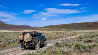

We bombed along - a combination of the reasonably maintained roads, reasonably small amounts of rain - less than 7" falling here annually, and recently adjusted ADS coilovers on the truck. I'd removed about ⅓ of the preload and boy, did that make the ride so much better than it had been on the last trip! Eventually, we came to some ranching cabins and stopped in for a look.


With that, we headed south and west - the road not as well maintained in places, but still nothing that a little speed didn't smooth out. It won't be long before my snails pace reputation is no longer really applicable. and I can only imagine that that'll mean for truck maintenance costs. Dang.
The views were fabtacular.

And then, as we were on our way down over the last pass into the Alvord Playa - less than 2 miles to the flat speedway that we could take to the hot springs and another so-out-in-the-open-it's-private camp site - we hit a bit of a problem. Those 7" of rain - over the last year or two or five - had washed out the road something fierce.
And yes, I realize it doesn't look all that bad in the photos. I should have had @mrs.turbodb go stand in the ditch, to give it a bit of scale. We're talking armpit level here for her in places.


We tried to skirt around, but I realized after walking a half mile further down the road that while we might be able to skirt around to get down, if we ran into something else closer to the Playa, it could have been nearly impossible to climb back up onto the shoulder to get back out - the soft, sandy soil offering little traction to a beast as heavy as the Tacoma.

So we made the disappointing call to turn around. Well, not to actually turn around - there was nowhere to do that - but to back up the side of the road until we cleared the washout, and then turn around. Then, already after 6:45pm, it was a suspension-cycling mad-dash back the way we'd come. We had a lot of miles to cover, and we preferred to do it with at least some daylight so as to avoid any deer-across-the-road situations.
Reasonably calm wind-wise, our dust lingered on the road behind us as the sky started to change color.

We sped west, and then north - the green tundra as far as the eye could see. Pronghorn bouncing away (good) as the miles ticked by. A small herd of wild horses also distancing themselves from the trail of dust we left in our wake.
We didn't make it back before sunset - which we enjoyed from the truck - but it wasn't long after that we pulled into the parking lot for Alvord Hot Springs and forked over the small (depending on who you ask) entrance fee to take a soak in the warm water.

It had been a full day - full of great highlights, near disasters, and turn-around-and-go-back-the-way-you-came failures. And a nap. We need more naps on trips.
We soaked for 30 minutes or so before heading out to our place on the Playa to setup camp and make dinner - tacos with guac - before calling it a night and climbing into bed. As the wind picked up around us, we hoped our earplugs would be enough to keep the flapping at bay, allowing us to be well rested for the next day.
Because we'd only planned one reasonably relaxing day for this trip...


Every now and then I get inspired to tell my side of the story. Here’s my write up of the first day of our trip to the Alvord. (Note: I wrote this without seeing @turbodb’s so it’ll be interesting to read the differences with you.)
On Wednesday April 24th, I started the day volunteering at school, where I was substituting for reading tutor, but honestly, my mind was elsewhere: I was getting really excited to go to the Alvord. Specifically, I was excited to return to the place of such eeriness and geological interest, and to just plain going exploring. And there are hot springs! And mountains! And wild horses! And and and…I was besides myself. I walked around the whole morning telling everyone how I was going to this crazy place. They let me out of recess duty and I ran home to get in the truck and go. Which is exactly what we did.
Ten and a half hours later and we arrived in the middle of the playa. We entered from the Frog Springs (aka “the West Entrance”) and drove a few miles across the playa under the stars and then turned a sharp left to get out of the way of any “traffic” that might come barreling across the playa in the late night or early morning. On a Wednesday night. In the Alvord, the land of no people. Still, good idea. The tent was set up in a matter of minutes and we were asleep shortly after.
April 25th
On Thursday, @turbodb woke up earlier than God and rolled out to capture the sunrise. I wisely stayed cozy in bed, though I was giddy and happy to be in the desert. The sun was bright and it wasn’t too cold out, which all added to my anticipation for this trips activities of hiking, hot springing, and generally getting lost with the GPS.
After his morning sunrise snaps, @turbodb let me know that there was in fact water on the playa – something we hadn’t seen before, but we knew had to happen sometimes – and what was more, we were only a few hundred feet from the edge. We were so lucky we hadn’t driven into it in the night, though I could just imagine the splashing would have been a give away.
There was also a random metal door not too far away. Why? Who knows. It’s the desert and random stuff shows up there, though mostly mylar balloons and plastic bags. Later we would find the broken bottom of a plastic hanging basket and a plastic tiger tooth. Deserts are nothing if not completely random.
Eventually, we got up, likely at the late hour of 7:30am, had some breakfast, and then headed due East. Driving on the playa is like floating or flying; you really have no idea how fast or slow you are going because nothing on the horizon seems to move and the ground is so smooth. So eerie. Then suddenly, we were in the grease brushes, just as our guidebook 100 hikes in Eastern Oregon by William L. Sullivan said we would be. This guidebook was the best purchase I’ve ever made for my kindle. If it were a real book, it would show all the wear and tear of how much I love it (and it might be better for looking at the maps). We use it on every trip to Oregon. Of all the books that I brought, I could have left all of them behind and just had this one. It became even more useful when I realized on our way down that I had forgotten our copy of Roadside Geology of Oregon (serious doh!!). As much as that book would have been useful, given that where we were was entirely on dirt and not pavement, there were few roads that would have been covered by that book. I consoled myself by remembering that I’d read most of it before and kind of had parts of it memorized, which helped me make stuff up while we were driving.
We parked at what was either a hitching post or a morbid A-frame for hanging carcasses after a hunt (we saw a number of these “hanging trees” on our previous OBDR trip – they seem sort of biblical), and set out toward Big Sand Gap following a combination of wild horse trails and dry stream beds. It is unclear to me why any wild horse would go down into the Alvord playa as there is absolutely nothing there and it seems like there would be better water to be had at any number of springs, but there was clear evidence (read: horse poop) that these trails were used by horses, and likely not just trail horses.
What started out as a flat walk became a sandy gradual hill climb. As always happens, first we saw one small patch of beautiful white flowers growing in a small clump, seemingly isolated and unique and out of place. Then we looked up and could see that from the point to the top of the hill were clumps of these white flowers spread every five feet. The desert was in bloom, and this was just the beginning.
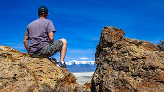
After about an hour and a half, we reached the Big Sand Gap – the spot where during the Pleistocene the giant Alvord lake burst through onto the Columbia Plateau and started the great flood that barreled down toward the Snake and Columbia rivers and helped carve out many interesting geological features along the way. What was left was a hole in the Eastern face of the desert, a big sand dune, and a view of the Columbia Plateau. And a road. It was a road that lead back to the playa one way and up over the sand dune into the yonder to the east. We’d have to explore that later, but for the time being, it was time to climb to the top of the cliff, and to sniff the abundance of purple and white wildflowers that covered the hillside leading up to the top just a few hundred yards away. These were the same wildflowers we’d encountered in Idaho at the top of the highest road in the state. They smell kind of like lilacs and they are definitely worth getting down into plank position just to smell. Not that I did that repeatedly while climbing up the steep rubble strewn hill.
Along the way, we found a few lizards darting in and out of the rocks, mostly trying to hide after getting caught sunning themselves. We also found a wind-created (my best guess) cave which would have made a cool hideout or shelter if it weren’t so windy. At points, I had to use my hands to climb up to the top. The basalt cliff was sheer on one side and steep on the other which made it very thin; it was no wonder why this was the place that the dam had burst. Various pillars of basalt were leaning away from the main cliff, waiting to fall and create more shaley rubble down toward the playa (away from the direction we were walking). Of course, @turbodb wanted me to pose for a picture as close to the edge as possible. Also, and of course, it was windy. I sat instead while he nimbly hoped over to an adjacent hill to take a long distance shot of the back of the cliff. Given the beautiful day and a snow covered Steens Mountain looming in the background above the white strip of the playa, I’m sure I was barely noticeable.
As we made our way back to the truck, we were both curious about the road we’d seen. William L. Sullivan had mentioned the road, calling it “ancient” – which just made me laugh – and Google didn’t have it on the map at all. But it was right there, clear as can be. We’d have to do something about that.
Back at the truck, we decided that we’d drive through the grease brush and find the entrance to the road and do some exploring. Fifteen minutes later, we were up on the sand dune that had taken us the entire morning hike. Of course, we couldn’t get all the way to the top of the cliff above, but still, American Hiking (aka truck does all the work) for the win! And still, the road beckoned to the east further, but that would be for another day, we promised ourselves. Perhaps tomorrow.
After our second victorious ascent, we decided to return to the middle of the playa to lunch and to take a nap. We headed straight out and after a few miles of flat/flying/spookiness, @turbodb slammed on the brakes – we were at the edge of the water again. Turning south, we followed the edge, wondering where the edge would be tomorrow after today’s round of sunny skies.
With our nap taken and being awoken by some curious old men on bicycles (have I mentioned that the desert can be a weird place?) who came by to check out the weird tent on a truck, we decided to get out of the stifling heat of the truck and to do some more exploring.
Our plan was to prove to ourselves that we could drive from highway 95 to the Alvord without having to go all the way up and around on pavement. You see, the first time we went to the Alvord, I had planned the trip. That trip was part of a hot springs adventure that included two days in Owhyhee and one day in the Alvord, and unfortunately, I didn’t think to drive on backroads between the two, even though during the trip it was pretty apparent that it would be possible, if only we’d planned it. If only!! Now was our chance to go back and explore that which was left unexplored before.
We drove north and passed by Mickey Hot Springs. Remarkably, another vehicle – a suburu – had just arrived ahead of us. A young couple had taken some lawn chairs and decided to set them up right on the edge of the bigger of springs and just kind of… look at it? Unclear. On the other hand, Mickey Hot Springs is kind of a cool other worldly kind of place, a mini-Yellowstone complete with bubbling mud pots, a mini geyser, giant holes of former hot springs, gas vents, barren moonscape, and active scalding hot springs, though none for taking a dip in. Having visited Mickey before, we said our hellos and then left within 10 minutes. I think the couple thought we were crazy for not staying longer to take in this geological wonder, but really we’d seen it before and were glad to let them have it all to themselves. We had (what we thought was) another hot springs to explore further east…
Last time, we were able to explore just a little before deciding to head home. Specifically, we had made it as far as the basic containing Crippled Horse Spring, where we wondered about the spiraling dust or steam cloud we saw in the distance. We thought it was someone doing donuts on the isolated playa, until we realized that no one was there. We promised ourselves we’d check it out, and now it was time to keep our promise.
At 4 o’clock, we parked on the side of weird desert valley, along the side by the wilderness boundary/no driving signs and started walking out onto the desert plain. We could see what looked like the spirals of steam rising and blowing off to the north, so we felt like we were onto something, but twenty minutes into our walk, it was clear that while the place was weird, there was no hot spring. There was a small rise to the north where @turbodb found a spring… mostly likely, the namesake of the basin. So spring, just not hot spring. At the southern end of the desert valley there was a cindercone like hill which just begged to be climbed. We obliged. Our view confirmed what we already knew, the steam puffs were really just dust devils kicked up by the persistent wind in the valley coming down off the Sheepshead mountains that surrounded us. But there was another surprise at the top – a fire ring and a geocache. The geocache was an old ammunition box and was dedicated to the memory of Harry O. Webb by his friends who would climb the hill to write remembrances of their friend and by other explorers like ourselves. The notes were touching and we left one of our own. We scrambled down and back to the car. By this point, another hour had passed.
On we went, determined to complete a small loop going out the northside of the Alvord by Mickey Springs and passed Crippled Horse/aka Harry’s Place, out onto the plateau and back in what @turbodb had dubbed on the map “The East Entrance” to the Alvord through another gap north of the Big Sand Gap. There were roads on Google Earth that said it could be done, and thus far, the road was navigable by any car, so we were confident that it could be done. We were wrong, but I digress.
We passed a rancher, who was happy to stop and chat for a moment. He confirmed that there was no hot springs in Crippled Horse, and that yes, one could definitely get out to highway 95 on the road we were on, and that the worst of the road was behind us. We thanked him and were on our way. With that information, we knew we didn’t have to go all the way out to 95 – the point had been made. Now we just wanted to see if we could get back to the Alvord a different way.
At a set of corrals, we turned off the dead straight gravel road that led to 95, and headed south, over a hill and toward Coyote Lake. Occasionally, a few antelope would jump away in the distance, and every now and then we’d honk at some cows on the road. Following our plan, after a few more miles, we headed east past some “high tech” watering holes that involved solar panels, a pump, and a PNG tank. After what was the last watering hole, the road became noticeable worse, reminding us both of the cobble roads that we traversed on our OBDR trip. The desert plain was beautiful and wide. We had started to climb and as we crested the top of the hill, we could see the road winding its way down to the playa with Steens Mountain in the distance. We were so close. It was also at this point that the road conditions began to deteriorate rapidly due to erosion. We got out and walked. While @turbodb was convinced that we could overcome the first road challenge, it was very likely that there was going to be worse road ahead (there was, we found it while walking) that we couldn’t overcome. According to the GPS, we were less than 3 miles from the playa. Not including our stops, it had taken us two hours to get here. But back we went. At least there were a few wild horses along the road to watch through the binoculars – they seemed perplexed to see us.
My not-so-secret plan on this trip was to make up for one other omission from last trip – hot springs dipping. Last time, we hadn’t gone to the Alvord Hot Springs. We’d gotten there too late and were leaving too early. Excuses excuses excuses. Yes, it cost money and more than seemed reasonable, especially to those who were not accustomed to paying for hot springs (see previous Owhyhee trip and Snively hot springs – free). But I wanted to go and we were both super bummed out. “3 miles! We were so close.” So we paid our $8 entrance fees, we joined the three other couples in the outdoor tub, and watched the clouds dance over the mile high snow covered bluff of Steens Mountain to the west and the lightening storm to the east, all while the suns rays disappeared and the stars started to come out. Propelled mostly by my growling stomach and the not-quite-warm enough temperature of the tub, we got out and made our way back to the playa – to very nearly the same spot we had napped and camped at before. Dinner was quick, even in the dark, and then we were in bed, snuggling and reading until we fell asleep, exhausted and somewhat disappointed, but excited by what tomorrow’s adventure would bring.