
July 20, 2019.
Hard at work as we slept, the fire fighters working on the Vader fire had it contained - as far as we could tell given the complete lack of rising smoke - by the time my alarm went off at 4:00am. As fires go, it hadn't been a huge, but at 443 acres, it had taken a crew of two Type 6 Engines, one Type 4 Engine, one Type II Initial Attack Fire Crew, a plane load of smokejumpers, two Type I Helicopters, four Type III Helicopters, an air‐attack, two Interagency Hotshot crews, and 2 dozers to rein it in. All that was left now was a blanket of smoke in the valley below.
Thanks all!


As the sun rose, we didn't - opting, for a while at least - to enjoy its warmth streaming in through the tent door. Still, we knew we had a lot of ground to cover - we'd only completed about 40% of the second stage of the IDBDR the day before, and we had a 20+ mile detour to get back on track due to the closure of FS-385. So, by 7:30am or so, we climbed down the ladder to another beautiful morning and another round of juicy, home-grown blueberries for breakfast.


Soon enough, the tent was stowed and we were on our way - Jackson Peak now in our rear view mirrors, the Tacoma making quick work of the dirt roads back to Highway 21. Having found a turn-off less than five miles up the road that seemed to bypass the closure, we didn't spend long on pavement - something that I'm sure other travelers appreciated.

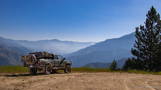
Back on dirt, we climbed up onto the ridgeline above Bannock before starting our descent east of Lowman. It was a twisty, fun section of the route - one that reaffirmed our decision to find our way back as quickly as possible instead of simply following Highway 21 (also beautiful) straight into Lowman.
As we wound our way down the mountain, we were descending into the smoke we'd seen from our vantage point atop Jackson Peak - high above the inversion zone we now found ourselves driving through.
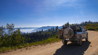

Below us, the Payette River - snaking its way through the valley, marking the point at which we'd come out of the mountains.

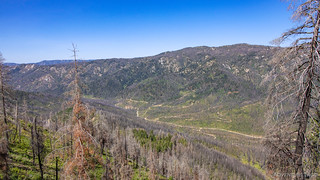
Even taking the scenic route, we continued to make good time - in general, the roads on the IBDR are in reasonably good shape. Comparable to (perhaps slightly worse than) what we experienced on the WABDR, and much better than the bone-rattling rockiness of the OBDR. Before long, we found ourselves out of the woods - much of it burnt - and just east of Lowman, where we'd be stopping for fuel.

It was here that we came across a reasonably informative USFS information station that used a single graphic to explain what we were seeing around us - namely, charred trees and a general lack of forest. What we were seeing was nature doing it's best to recover from the 1989 Lowman fire, which burned 72 square miles of forest - an area larger than the Boise metropolitan area. Over the month that it took to contain the blaze, and despite the efforts of more than 2,300 firefighters, 26 structures in the community of Lowman were destroyed.

Of course, it didn't have to happen this way.
For millions of years, fires have helped to maintain the forests of the world, severe fires historically occurring every 13-16 years in this area. However, over the last 100 years, this natural cycle has been altered by humans fighting fires to "save" the forest. As a result, unnaturally abundant fuels built up in the Lowman area and In 1989 - with high fuel levels and low precipitation - normal summer rains were replaced by dry lightning storms. These storms started 157 fires (36 in one day) in July of 1989, across the Boise National Forest.USFS info board
Making seemingly slower progress on pavement than dirt - it's amazing how sluggish the truck feels when aired down on the highway - we tootled our way along until we reached Lowman and our pit stop for gas. While filling up, I had a chat with the station owner about the next leg of our journey. See, the BDR website had a warning for a water crossing in this section, saying that it was "dangerous" with "water levels so high." So, I asked if he knew the roads in the area and was familiar with this crossing they were talking about.
"You'll be just fine." He chuckled, "But you're wasting your time. That's an old logging road that they should really just take out - the new road they put in is a lot quicker."
I laughed and thanked him for the info - we were of course going the "waste of time" way. And can I just say how much I appreciate the little middle-of-nowhere stations like the Lowman Hitching Post that still let you pump your gas before going inside to pay. Without requiring multiple trips to first leave a credit card or the SSN of your first born child. Assuming the best in people, rather than the worst. It's refreshing.
Still only mid-morning, we began the climb out of Lowman on FS-582. Once again through forest burned some 30 years ago, it was hard to argue that there's something to be said for the views afforded by such a landscape.


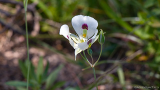
And it wasn't just the distant vistas that we enjoyed. @mrs.turbodb also enjoyed a nap or two, my frequent photo stops to capture the wildflowers that were in full bloom at these elevations, interrupting her slumber.


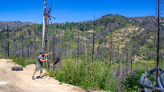
And then, as we descended towards a water-crossing that we were both looking forward to - a bit of excitement! There, across the road - a fallen tree. An old burn, this one quite clearly came down as a result of an unstable base and perhaps just the right gust of wind - it had blocked just enough of the road that ATVs and motorcycles could get by, but trucks were a no-go.
A smile on my face, I looked at @mrs.turbodb and said, "Time for the chainsaw, grab the camera!"
Now, she'll be the first to tell you that chainsaws are just as likely to get you into trouble as they are to get you out of it - in fact, she calls them "hubris wands" for that very reason. But, she obliged my childish request and before long, I was sweaty and we were ready to go.


In no time flat, we'd reached the water crossing. And, while I guess it was technically a water crossing, to suggest that it was any kind of trouble - much less the kind that deserved a skull and crossbones on the map - was pushing it.
For good measure, we went through three times. You know, just to make sure we didn't miss anything.


From there, we had a decision to make - west was back onto the route, where we were still a good half-day behind schedule; east would take us to Whitehawk Fire Lookout - where we could enjoy lunch, hopefully with an amazing view. It wasn't a hard decision really - even running behind schedule, it's not like we had anywhere to be - so we headed east.


Perhaps predictably - given our previous two lookout experiences - we got within a mile or so of our destination only to run into a locked gate. We joked that they were embarrassed - all these "failed" lookouts, surrounded by burned forest, closed off from prying eyes.

Not that we couldn't have just hiked that last mile...
But, with the outside temps now in the mid 90°F's, we opted for the relatively cool breeze from the truck travelling at 30mph, and made a quick u-turn to head back the way we'd come - now on the lookout for a shady spot among the burnt forest to make and eat lunch.

It took a good 45 minutes or so - our stomachs getting hungrier and hungrier - before we finally found a suitable spot to enjoy sandwhiches that @mrs.turbodb whipped up on the tailgate. Sure, we were only sort-of-out-of-the-middle-of-the-road, but were we really going to run into anyone out here in the middle of nowhere?

Bellies full, we weren't back in the truck for more than 15 minutes when we pulled over for an oncoming motorcycle. Good timing to be back on the move it seemed! As the motorcycle squeezed by us, we noticed a 3rd gen 4Runner a little ways back. He'd seen us as well and had pulled over in a spot where more than just a skinny bike could fit by. We rolled up slowly to say hi and thanks, and just as we were about to continue on our way, I noticed brake lights and the drivers door open in my side view mirror.

Walking over, driver of the 4Runner said, "Hey, are you turbo?"
You can imagine our surprise. Even now, I'm a bit incredulous. Turns out, it was Durwin @owyheerat and his buddy - out enjoying the area - making their way home from Deadwood Reservoir. We chatted for a few minutes, smiles all around and curious what we were each doing out and about, before wishing each other well and continuing on our way - such an awesome world!

Winding our way down the mountain, we retraced Durwin's steps towards Deadwood Reservoir, hoping for a spectacular view from high above - something we hadn't seen a couple weeks earlier when we'd visited this same area via an alternate route.

Unfortunately - despite a few promising looking opportunities on the map - there always seemed to be a low mountain range between us and the water, and soon we were back on the highway-like FS-555 road, speeding along next to the lake, doing our best to remove ourselves from what we'd termed "Crowdaho" a few weeks earlier and which had only seemed to get more populated.

From Deadwood Reservoir, our next destination was Yellow Pine - a little town that marked the end of the stage we'd started two days earlier - still some 55 miles away! Luckily for us, the roads were in good shape, and it was beautiful country, even if we'd missed the height of spring - the last of the wildflowers now blooming on the edges of Tyndall Meadows.

As the miles ticked away, we found ourselves climbing again - more gradually than we had earlier in the day - once again up near 7000', the elevation giving us at least a little relief from the afternoon heat. And, for what felt like one of the first times on the trip, we found ourselves in a forest of green!


Just outside Yellow Pine, we made a quick stop for a Pioneer Cemetery - expecting to see the resting place of some of the good folks - or rather, people of the same era - that @mrs.turbodb had been reading to us about in her books on the early days of Idaho exploration. Turns out, the graves (and memorials) we found were actually rather new - the oldest we could find being 1954.


As such, we didn't linger. Yellow Pine was now less than a mile away, and we knew that we needed to make some reasonable forward progress even beyond this little town, if we were going to maintain any semblance of our schedule. As we pulled into town, it was exactly what we expected - a small place with it's residents milling about on main street. Cute, and laid back.
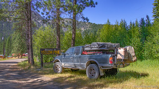

In search of fuel, we finally found it on our second pass through town - in an above-ground tank, with a hand-made sign indicating it's price. Clearly, it was laced with gold.

At $6.00 for every gallon, I looked over at @mrs.turbodb and asked, "How far is it to our next fuel stop?" Having paid what I thought was a lot in Jarbidge, this was even more costly than fuel in Death Valley - so if we could avoid it, I thought we should - especially since this time we were looking at 10-12 gallons to get the tank back up to full.
And so it was - with 205 miles to the end of the next stage - that we headed out of Yellow Pine, our estimate that we had 110 miles of fuel left in the tank, and another 150 or so in the jerry cans. Only time would tell if we were genius or ignoramus.

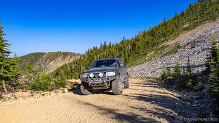
As was quickly becoming a trend, we found ourselves winding our way up into the mountains - as though the planners of the IDBDR had decided that the point of this route would be to climb and descend every range they could find. It was, as we remarked to ourselves - just perfect when you're low on gas! 
We didn't make many stops along the way - our primary goal now, to get some miles behind us on stage 3. We did however make a quick stop in the town of Big Creek to snap a shot of their cool old fire engine, still apparently in service!


And then, we continued up. And up and up and up. I could almost feel the truck getting lighter as the fuel needle entered a state that I can only call free-fall. I hoped we hadn't made the wrong decision. But, I told myself, this is exactly why we carry 10 gallons of spare fuel - if you're never going to use it, there's no point in bringing it.
Eventually, we found ourselves 8670' above sea level at Elk Summit. It was much cooler here - and windy. We'd hoped to find a nice spot to camp up here in the sky, but with snow on the ground, and unsure what traffic would be like in this area (since we'd be camped right next to the road), we decided to push forward even further, hoping to find something a little more out of the way down the north side of the mountain.


Heading down, we shed elevation just as quickly as we'd gained it going up. Of course, given how our Tacoma's work, it didn't make me feel any better about our fuel situation - since when the truck is pitched forward, the floats in the tank read a lower amount of fuel. It's all just an illusion I kept telling myself, doing my best to enjoy the scenery - complete with nature's snow cones - as we descended into the valley, the evening sun casting warm light on the hillsides all around.


As we neared the bottom, we stopped - for what turned out to be our last time before finding camp - at the Elk Creek Cemetery. Unlike what we'd found in Yellow Pine, this was a true Pioneer Cemetery - it's permanent residents all taking up residence in the late 1800's, each one with a colorful story.


Sylvester S. Smith (aka "3 Finger Smith") had an active part in the Sheepeater Indian War. Most of that took place in the Indian Valley area where he and his wife, Sylvia, lived - at the mouth of Elk Creek - and raised four sons, Samuel, Warren, Henry and Robert.
While talking with some friends, he placed hands over the barrel of his shot gun. Something caused the gun to fire, blowing off two fingers on each hand. Thus, the name "3 Finger Smith".
Peter Dorsey and Hough Johnson had a place upriver from the Smith place. They hired a couple of Sheepeater Indians to do some work, then refused to pay the Indians, who came back and killed them. Their remains were found by neighbors and buried here.
Robert Smith froze to death while trying to carry a packet of mail over elk summit to the Alton mining district.
Warren Smith died at the Hackett Ranch, a few miles up Elk Creek.
Bert Elliott was killed near elk summit. He was riding on a freight wagon when struck in the head by a rock. A road repair crew was dynamiting nearby.placard nearby
Nearly 8:30pm, we were now on the serious hunt for a place to call home for the night. We tried a few little pull-outs, not caring about their distance to the road, but still deciding against the first couple given the tall grass and pitched ground. Eventually though, we pulled up on a perfect little remote campground on the South Fork of the Salmon River and knew this was just the place for us.
I got the tent setup while @mrs.turbodb prepped a delicious rotisserie chicken and home-grown green beans, which we enjoyed by the river as it rushed by.

It was here too that we met - for the first time - another set of motorcycle riders that we'd play leapfrog with for the next several days. They weren't running the IDBDR, but were overlapping the part of it that we happened to be on, as they explored some of the backcountry of Idaho that we'd explored just a few weeks earlier!
And so it was that as the sun set on another day that we climbed into the tent. Not yet back on schedule, but having made up at least a bit of time on the route. Knowing that the next day would be an interesting one - where we'd either be proven genius, or find ourselves walking the last several miles to Elk City get fuel!
The Whole Story
")


")
")

")


")


")
")
")
")
")


Great photos and entertaining as usual