
July 21, 2019.
Camped deep in the valley next to the South Fork of the Salmon River, getting up for sunrise wasn't even an option for us. The dual-sport bikers had we'd met the night before were surely later to bed and earlier to rise than we were, but that was just fine by us - we needed our beauty rest, bad.
So it was that when the sun finally did start warming the tent that we figured we might as well continue on our route - I mean, it was either that or go back the way we'd come - we were after all, a long way from home.

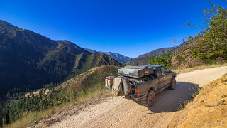
As was becoming routine, we breakfasted and broke down camp before setting off across the river - this time, with the assistance of a bridge, the water levels too high, even for a Tacoma.


Almost immediately - yep, you guessed it - we started to climb. Up and out of the canyon, two male deer watching as we negotiated the switchbacks - something we'd been warned was extremely dangerous by one of the riders.


Turns out, it was the same way that the water crossing the day before was dangerous - which is to say, compared to eating tacos. 
This morning, the easy road was just fine with us - we still had a good 150+ miles to go, and not a lot of fuel, so any roads that were well-graded and easy to travel were a plus. We made our way along the ridge and were just west of China Mountain when we started noticed the beginnings of civilization - we'd reached the outskirts of Warren, Idaho.

Totally within the Taco's towing capacity.
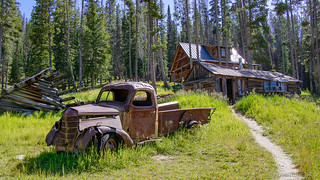
An old mining town, Warren's (named for James Warren who discovered gold in the area) current full-time population of 12 residents pales in comparison to the 2,000+ residents who called it home in the gold rush of 1862. Then in the Washington Territory, it is one of the oldest settlements in present-day Idaho. At the time of it's founding, the impending Civil War resulted in northerners calling the town "Washington" and southerners, "Richmond." Eventually, it was known for its Chinese population, before being dredged in the 1930's - miles and miles of dredge tailings still prominent in the valley to this day.

Many of the buildings still intact - and a "walking tour" of Main Street available at the now-a-museum guard station to supplement what we'd read in Roadside History of Idaho - we set out to explore, a bit perplexed by some of the sights we saw initially, the town seemingly abuzz with people.


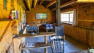
Having passed the old Warren School, with its backwards 'N', and the holds-up-the-radio-antenna Hotel, we found ourselves at the Dance Hall and old Saloon. It was here that we finally realized why the town seemed so alive - there'd been a wedding the day before, many of the old buildings still used for the momentous occasion. Now nearly 10:00am, everyone was just waking up, to clean up after the festivities.


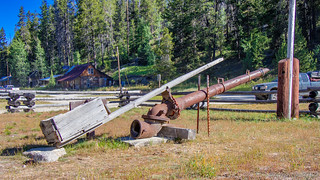
On our way out of town, we passed one last relic - an old excavator - surely an engineering marvel in its time, now rendered obsolete by much more capable machines.

Unlike our trip so far - where traffic had been light - leaving Warren was a traffic jam, wedding attendees in their full-size trucks and 40' RV trailers making their way slowly out of the mountains. Luckily for us, they were reasonably attentive to their mirrors and we were able to quickly zoom by and out of their dusty wake.
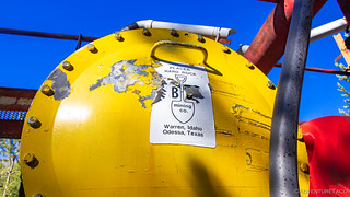
Speeding along on what was effectively a gravel superhighway, it was less than 15 miles before we reached a site that was high on @mrs.turbodb's list of stops we had to make - Burgdorf Hot Springs. Not because it was historically interesting, but because it would allow us a dip in the warm goodness.

It turns out that the Burgdorf story is perhaps the most pragmatic of the area. According to Southern Idaho Ghost Towns, it was known as simply "Warm Springs" to the earliest travelers - but in 1870, Fritz Burgdorf saw the advantages of the natural springs and secured a deed to the land, on which he built a hotel and way station.
Smart dude if you ask me - making money no matter how much gold was pulled out of the nearby hills! To this day, the resort continues to serve as a social gathering place, several of its rustic cabins available for rent.
In the end, it turned out that we didn't go for a dip in the spring - the idea of paying to get in hot sulfur-water under the 85°F sun, with no ability to shower afterward a little too much even for us. Instead, we climbed back into the Tacoma, turned on the air conditioning, and looked forward to whatever lay ahead. We'd have plenty of time for hot springs in the future.
Over the course of the next couple hours, I wouldn't say that the views from the trail were the most fabtacular of the trip, but that didn't mean that highlights didn't present themselves. In fact, there were at least four worth calling out.
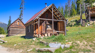
First up was the Edmundson Cabin. Not mentioned by the BDR route planners or any of our books, it was a complete surprise when we came upon it...not that we were complaining in the least! Turns out that this was a place that heavy freight wagons hauling supplies and equipment - brought in on the Salmon and destined for the gold mines near Warren - would stop to rest for the night.


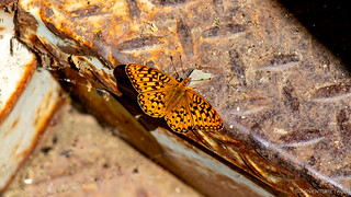
Next was an old school bus. Long ago retired from the child-hauling business, it had been converted into a residence - some wooden shingles, a wood heat stove, and remnants of an electrical panel still evident. Now however, it's just another weird thing to stumble upon out in the middle of nowhere and take a picture of, perhaps with a butterfly on one of its steps!

Shortly after the bus, we came upon the third interesting section of trail. This was a section we'd been looking forward to since we discovered it in Backcountry Navigator earlier in the day.

I mean, how could that not be a fun section? I could only hope that the switchbacks were as tight in person as they looked on the map. Of course, they weren't, but they still provided us plenty of downhill - appreciated given our fuel situation - as well as the opportunity to witness a man walking his pack animals down the mountain, straight out of the late 1800's.


And with that, we reached the Salmon River. Not the North-Fork-of-the-West-Edge-of-the-Primary-Feeder-of-the-Source-of-the-Salmon-River, the real deal.


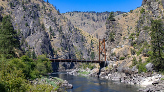
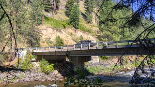
Finally, just a few miles downstream, we hit the fourth cool landmark worth mentioning - the Manning Bridge. A "half" suspension bridge, it was put into service in June 2018, replacing an earlier model that was built in 1934. Just as interesting as the bridge itself - at least in my opinion - is a rock on the north side of the river, which was ground down with some circular grinder - its face polished and gray, a stark contrast to the natural rock around it.


It was here, as the road changed from gravel to pavement as it followed the path of the Salmon River through the canyon - that we decided we ought to stop for lunch. I mean, we could have kept going - it was just noon, and so still rather early - but we knew that our future likely held dusty roads and less shade than we'd find along this majestic water way. So, it was lunch time.
As sandwiches were made, I set about transferring fuel from the Jerry Cans into the gas tank. We'd traveled 102 of our 205 miles - and with a quarter tank left, we were doing great. We'd definitely need both cans, but we'd only use a gallon or two out of the second can, assuming we didn't run into any unforeseen rock crawling sections.

Soon enough, I was done, lunch was prepared, and we sat in the shade on the bank of the river, enjoying our sandwiches, chips, and the last of our fresh u-pick cherries. The only thing that could have made it any better was some reminder of the majesty of this place.
Right on cue, a bald eagle soared in and landed in a tree just across the river. #MajestyCheckmate

We waited a long time after finishing our food for the bald eagle to spot some delicious morsel and fly away, hoping to catch a photo of it in flight - but alas, it was content to sit and preen much longer than our patience. So we packed everything back up, marveled at a fuel gauge that now read nearly ¾ of a tank, and did what we seemed to do everywhere - we started climbing up and out of the canyon and over the next ridge!


We naturally got some great views as we gained elevation, Hershey Point and Sam's Throne visible in the distance. But we also entered a different type of forest than we'd found ourselves in to this point - one that was being actively logged. As we climbed higher, and made our way northeast towards the ghost town of Florence, we alternated between thick woods and bare hillside, the mangled rootballs and charred remains of burn piles all around.
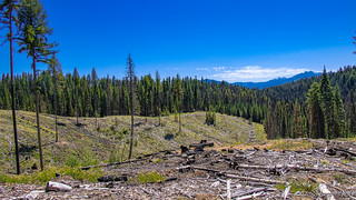
As much as I'm for management of our forests in order to prevent fires such as the 1989 Lowman Fire, I'm not sure this is quite the right approach either. Rather, I'm a fan of something something in-between.
Around 2:00pm, we arrived in Florence - something we (and by 'we' I mean especially @mrs.turbodb) had been looking forward to since we set out on this excursion. Little did we know - though perhaps it should have been obvious - that we weren't actually in Florence proper; we were in New Florence.

Florence it turns out, is completely gone - the town totally abandoned in 1951, some 90 years after it was established in the winter of 1861 as a mining camp, soon becoming the Idaho County seat - a distinction it held despite a dwindling population - until the seat moved to Warren in 1869.
Today, only a few run-down buildings remain even in New Florence. It's obvious though that someone is working to preserve what's left - a few roads and signs having appeared to educate explorers about the little that's still standing.


A two-holer. Apparently even pioneer women always went together?
A bit further up the road - between New- and Old Florence - was the Cemetery. This place had clearly been worked on by the Forest Service - all of the original headstones having been replaced with wooden slabs. Still, it was a little creepy - with "unknown" carved in over half of the headstones, and a marker denoting several Chinese graves that had been "exhumed."


Ready to move on, and with Florence having represented our last ridge climb of the day, we made our way north towards Highway 14 and the South Fork of the Clearwater River. It was pavement, but it was pavement that we knew would lead us to fuel and a grocery store - two places we hoped to reach before they closed for the day.

Of course, by the time we crossed the Clearwater and slowly - given that we were aired down - made our way to Elk city, it was 6:00pm on a Sunday. Both the gas station and grocery store were closed, though they were set to open by 8:00am the next morning.
And that meant it was time to find camp. I knew from a trip on the Old Elk City Wagon Trail with Mike @Digiratus and Dan @drr the year before that we could find something along that route - but hoping to find something a bit closer, we ventured up some nearby Forest Service roads until we found one that suited our fancy.
It didn't have the spectacular views or a river flowing alongside, and the flies were out in droves - but it was out of the way, flat, and had an eastern orientation - hopefully a good sign for sunrise the next day. Oh, and there were no mosquitoes - a big plus in our book.

Dinner was tasty as usual - cheeseburgers with our last avocado, and potato chips in place of fries; not much to complain about after nearly a week on the road.
And then, the flies out in force, we decided to get some relief by hanging out in the tent - the idea being that we'd read until sunset, but reality being that we'd be asleep well before the sun hit the horizon.

Either way, we planned on an early morning the next day - it'd taken us three days to do the last two stages, and we hoped to do a stage-plus-some by the time we found our next camp.
It was an ambitious plan given that the next stage included the entirely of the Macgruder Corridor, and the Lolo Motorway was the stage after that...
The Whole Story
")


")
")

")


")


")
")
")
")
")

