
July 25, 2019.
I wasn't sure how sunrise would be given that we were in a bit of a bowl around Dworshak Reservoir - with no line of sight to the horizon - and no clouds in the sky - it could be a complete dud. And for the most part, that's what it was. Unimpressed, I went back to sleep.

Having made good time yesterday, we still had a lot of making up to do - given our little brake caliper issue on the Lolo Motorway, and the fact that we'd spent two days completing the second stage of the IDBDR - so we got up reasonably early and ate a quick breakfast of granola bars before getting packed up and on our way just before 8:00am.


Still in the land of Potlatch Corporation, we enjoyed good roads for an hour or so until we reached the leased/private/public land boundary - where I assume that USFS became responsible for the road, and it quickly went to sh!t. Until then though, we had mile markers and designated CB channels to call out our position - you know, so we weren't hit by any logging trucks barreling down the road with a full load.


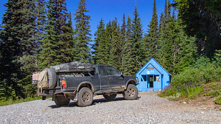
Of course, we didn't mind the roads-less-traveled, our aired down tires and reasonable suspension absorbing nearly everything that was thrown at them. Still making our way up and out of the bowl, we eventually came up on the Blue Heaven Cabin. A warming hut that's been painted blue (duh!), it's available year round on a first come basis and even on this warm morning, the front door was open and there was a bit of smoke coming out of the chimney - hopefully for cooking breakfast rather than warming the place up!
Not wanting to disturb the occupants, we didn't linger or look around - opting instead to push forward towards the town of Avery, Idaho - the next waypoint we had on the route, and one with a bit of history to boot.
As we crested the final ridge however, we saw a Jeep Wrangler stopped in the road - one of it's occupants out of the vehicle, looking around on the ground. Naturally we stopped to make sure everything was OK. It was, the driver informed us - they were just a couple rock hounds out hunting for Azurite - a blue crystal - found in the area. So we continued on our way down the hill, eventually passing through a tunnel before finally arriving in the sleepy little town of Avery.

Avery it turns out was once a bustling hub - a transportation center for the Cicago, Milwaukee, St. Paul and Pacific Railroads and a logging community for over 100 years. But fires in the early 1900s caused widespread panic - many residents fleeing; those who couldn't, finding refuge in the newly constructed railroad tunnels as the fires burned. Ultimately, fire fighters set back fires to save the town, but the damage was done. Today, 25 permanent residents call Avery home.
Still, it's fun to hear stories from the old days and think just how crazy the times must have been...
I was cookin' the doughnuts and biscuits. Old Baldy Fropes he cooked the bacon and ham and somebody was the coffee cook.
We had to have a cook for each article. We had them Kimmel stoves about 4 ft. long and 3 ft. wide and no bottom except the ground. Paul Resor fired while I cooked doughnuts on top of the stove. It kept him busy pokin wood in all them stoves. I mixed dough in a big container, then slopped flour on the board and put a wad of dough on it and slipped more flower on top and patted it out. Then I rolled it with a candle using both hands. Then I cut the doughnuts square and shoved my thumb through the middle to make a hole and slipped 'em in the fry grease.Ed Hanson, from Roadside History of Idaho
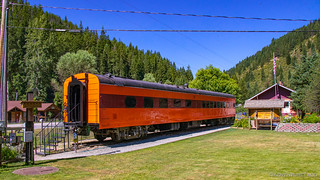
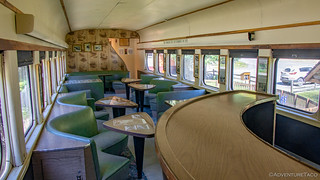
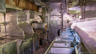
In the center of town - at the only intersection - an old dining car still sits on the side of the road, now converted into a museum. I got out and investigated a bit - it must have been quite the experience to ride in one of these trains in their heyday.
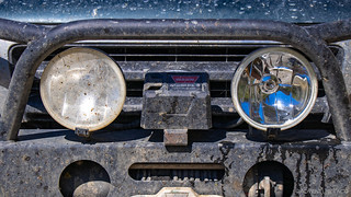
We also took the opportunity to refuel while we were in Avery, though I think we found the local's gas station rather than the normal station that out-of-towners generally use. Completely unstaffed, we saved ourselves over $1/gallon compared to the fuel on the highway, and we were able to shine up the front of the truck a bit as well.
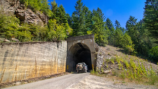
From Avery, the IDBDR splits. Not for long - the two possible routes are separated only by the St. Joe River that runs between them - but each route has it's highlights. To the west, the road follows the old rail line through several tunnels. To the east, the road follows another rail line over several trestles.
We chose the west - and will forever wonder if we made the right call!  The tunnels though were cool, and I'm sure either route is equally intriguing.


Whichever route you choose, after about 7 miles, the two routes join back together and the track continues north towards Wallace - a reasonably large town (as towns on the IDBDR go), nestled under the I-90 freeway. Because of this, the road is obviously well-traveled and meticulously graded - but very dusty. We got stuck behind a dually for the first several miles, and I felt like not only did the truck need a shower, but so did @mrs.turbodb and I.
Eventually we got around into the clean air, and we kept our pace up to ensure that we were at no risk of being passed again - the dust so thick it was blinding.

At about the same time the gravel road became an oiled gravel road, we happened upon a memorial that we couldn't pass by without stopping. Remembering the great fire of 1910, it tells the story of one Edward C. Pulaski - a Forest Ranger and leader of 45 men fighting the fire. Six of those men died, but Pulaski is credited with saving the lives of the remaining men by leading them into train tunnels until the fire passed.


And that is where the name of a Pulaski comes from!

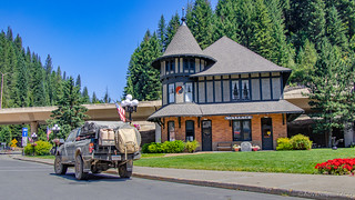
Less concerned with traffic in front of us on the road at this point, we made our into and through Wallace - a cute little town that would likely be the bees knees for someone touring around old towns of Idaho.

But that wasn't us. For us, Wallace was simply the end of section 6 and the beginning of section 7 - an exciting milestone to be sure. Plus, we were looking for somewhere a bit more...rustic to eat lunch. So we did what we'd done dozens of times over the last week - we hit dirt of this new stage, and started to climb a mountain.
An hour later, we found the perfect place for lunch. The view was obviously to die for, and we enjoyed it almost - but not quite - as much as the shade that came along with it!

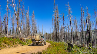
See, we were back in the land of burned woods - with all the pros and cons that go along with that; better views, but no shade for miles. Here and there we'd see fire lines - generally that had failed - as they worked their way across the hillsides. A lot of work it must have been to build those, and I can only imagine the feeling of disappointment when the fire jumped the line.

Having eaten lunch near the top of the ridge, we commenced our descent into the next valley north. Down we went, the elevation profile of this section of trail indicating that we we'd just gained 2000', would now be losing 2500', and would then get to climb 3000'. This time though, we had plenty of fuel. 

Resigned to the up-and-down-only-to-go-up-again, we were probably halfway through our next up when 50' in front of us, a moose came barreling out of the underbrush on the driver side of the truck. On an uphill gradient, it was reasonably easy for me to slow down and so as surprising as it was, we were both thrilled to see the moose, a rare occurrence for us.

We followed it for a good half mile or so, I'd say, before it finally found a suitable spot to exit the side of the road.
Reinvigorated by the excitement of the moose, we - perhaps a bit more cautiously - continued on. Over mountains and through valleys, we were covering varied landscape at this point - the southern faces hot and dry, the northern cool and shady. And of course, at the bottom of each valley, rivers. It was a pleasant change from some of the monotony that we'd seen in earlier stages.
Oh, and there were wild huckleberries to boot!


And then - another moose on the road!

Seriously crazy to have that happen twice in an hour. Likely a once in a lifetime experience for us. We were making great progress through the stage and soon enough, we found ourselves in another burn and riding along the top of another ridge, a short side trip taking us up to Grassy Point - perhaps the buggiest spot that we visited the entire trip.

Though the bugs were just gnats, we couldn't bear the swarms of them, and cut short our admiring the views - @mrs.turbodb doing her viewing from inside the truck.

Now nearing the halfway point of section 7 - which we'd only just begun at lunch - we were making amazing time. We've actually found this to be the case on all the BDRs that we've run - as you get closer to the end, the sections seem to go faster. Almost as if the original creators of the route were getting tired, and just wanted to be done.
It's a double-edged sword of course - on the one hand, we too were ready for showers; on the other, we were likely bypassing some amazing opportunities that we didn't even know existed.
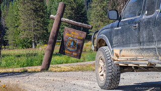
One that we weren't bypassing was the old Magee Ranger Station. In what is perhaps the definition of middle-of-nowhere along Teepee Creek, the ranger station and airport are no longer staffed, but belong to the pool of USFS dwellings that you can rent for a night, should that be your thing.
It's not ours, but that didn't stop us from checking out the old buildings.

From there, it was a reasonably straight - and definitely well-graded - shot into the town of Clark Fork where we quickly filled up with fuel and set out on our third stage of the day - stage 8, the final stage of the route!
It was - at this point - early evening, and feeling good about having made up an entire day or more, we figured that if we found a nice camp site, we'd just go ahead and stop. The problem was - perhaps because we were reasonably close to town - there weren't a lot of good camp sites, and those that looked reasonable were already occupied.
Soon, we found ourselves some 10 miles into the stage already, a sign along the side of the road advertising Char Falls. As much as we were ready to settle down, we couldn't pass up a falls. A short spur road led us to a parking area/camp site that would have been a great spot to camp had it not been quite so damp, where we set out on a quarter mile jaunt to see the falls themselves.
We were definitely glad we did - the water falling some 50' over a rock face, and (for me) a vantage point from directly above the falls.

Our visit here was quick, as we continued to look for a suitable place to spend the night. We knew that another 15 miles up the road was Lunch Mountain Lookout, and as is generally the case, I was rooting for that to be our stopping point - the views from lookouts generally spectacular by definition.

It soon became clear that even though it'd take us another 30 minutes to get there, we definitely weren't going to find anything better - and so we continued on with purpose, hoping that this lookout would be accessible... and that if it were staffed, we'd be allowed to camp below.

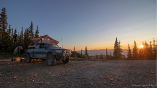
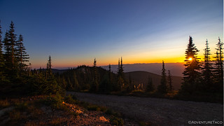
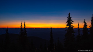
Well, when we arrived, one thing was for certain - this was going to be a great view. We'd raced to the top of Lunch Mountain, hoping to catch the sunset - and we'd made it just in the nick of time - perhaps 15 minutes or so before what was sure to be a dramatic moment.


And, the lookout was open - a young guy inside. We asked permission to come up - which was granted - and bearing chocolate we made our way up the stairs. Turns out, when we got to the top and went inside, it was a lookout like no other we'd seen - there were nice hardwood floors, and no Osborne Fire Finder (that circular sighting tool that's always in the middle of the lookout).
What was going on here?
When we asked the young guy about it, he looked at us like we were crazy. "They don't staff these lookouts any more, I rented this one for the last three nights." he said.
And suddenly things became a lot more clear :).
Intrigued, we chatted for a few minutes to tell him about all the "unstaffed" lookouts we'd chatted with over the last week of our trip, all getting a good laugh out of that one. Turns out that he'd grown up in the Coeur d'Alene area, exploring the forest in his spare time. He'd been trying to rent this lookout for years, and had finally gotten it - taking full advantage over his three-day stay - riding his bike through the woods, fishing, and having a great time.
And he was more than willing to let us setup camp below him, which was awesome.
So, we headed down the hill just a bit so we weren't right on top of him... or I guess, so he wasn't right on top of us and set about our dinner routine for the last time. Cheese ravioli with a meat arriabata sauce was on the menu, along with the last of our homegrown green beans. Yum!
Dinner prepped as the sun set, the problem with this site was immediately obvious - mosquitoes. Tons of them. So many that even with the hoods up on our sweatshirts, they'd fly into the hood, seeking out a bit of bare skin on which to land and attempt enjoyment of our tasty dinner, directly through our bloodstream.
Hate those little buggers!
What could have been an extremely enjoyable evening was instead a rush to get into the tent - its screened windows and doors the only thing that offered true protection from the tiny terrorists all around. So we ate quickly, and got everything cleaned up and put away - the only thing left to do, open the door and try to get in without bringing 10 mosquitoes with us.
It was about this time that a group of seven built Jeeps also showed up - their BroBars blasting billions of gigawatts of LED light around the place, their Dorkles sucking in the dust filled air from the Jeep in front of them. Windows down, they were rowdy and at least partially intoxicated as they made their way past our camp and up to the lookout.
Luckily, we were far enough away that they didn't bother us all that much as we enjoyed the last of sunset from the safety of our tent, but we felt sorry for the guy staying up there - it couldn't have been fun to have that crowd around until 11:00pm, disturbing his last night in a favorite place.

By the time they decided to leave, we'd been asleep for an hour or more. But, with that ruckus coming down the trail, and several small suns illuminating the mountaintop, their exit wasn't something that went unnoticed. Glad they were gone, we snuggled back down in our covers and fell back asleep to the sound of mosquitoes buzzing all around the outside of the tent.
Knowing that tomorrow would be the day - the day we made a run for the Canadian border!
The Whole Story
")


")
")

")


")


")
")
")
")
")


Char Falls was also cool because there were wild giant Delphiniums. I was so excited to see them!
Really enjoying your travel logs. I am planning to head out that way at some point in my trusty Toyota and RTT. Appreciate all the info. I have been a little surprised at your encounters with mosquitoes and gnats at those elevations, don't know why. I suppose there is enough standing water to support them. Being from S.C. they are just part of the landscape. Gnats are especially annoying but there is spray that works pretty good and cigars if you are desperate, lol. We use the Therma Cells for mosquitoes and they work well. NoSeeUms/Sand gnats are a another issue. Just cover your skin...all of it. Happy Trails and keep up the good work!
Hey Rob,
Thanks for reading and glad you're enjoying. We were a bit surprised by the bugs too - my guess is that at the elevations we were at, it was still "early spring" and so enough water still around from snow melt that the bugs were in their prime. Could be that even now (a month later), they're all gone.
Cheers!
Not surprised you ran into 7 Brodozers in that part of Idaho. Great trip reports! I was just in alot of the same areas a few weeks ago.
Glad you're enjoying!