
July 24, 2019.
Rocky Point proved once again to be one of the best camp sites of our trip and we slept well through the night. Wanting to capture sunrise, I was up early with a new idea - video - which also allowed me to catch another 90 minutes of sleep and yet still not miss anything!
Let me tell you, it was quite pleasant to wake up with the sun streaming in through the door at our feet, it's orange morning light illuminating the lookout visible through opposite side of the tent.


Even with the extra sleep, sunrise was still early enough - and we knew we had a lot of ground to make up - that we were out of the tent and eating a granola bar breakfast by 7:00am. We chatted for another half hour with our gracious host, each wishing each other a safe journey and summer, thankful for the time we'd spent together. And then, we set off again - hopeful that this time we would finally complete the Lolo Motorway.

The Lolo Motorway is a special road in American history. A route used for hundreds of years by Native American Indians, it was also the route that Lewis and Clark took on their travels west - and every few miles, there is an informative sign explaining their trials and tribulations on the trail. Later, it became a destination for early automobiles, a motorway through the woods. If there'd been Instagram, they'd have been #Overlanders. 


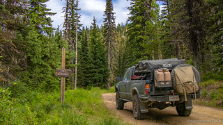
Moving right along, this eastern end of the Motorway was in great shape - the road reasonably graded and while not a completely smooth ride, one that still allowed us to travel at a reasonable 20mph or so - this guy hopping out of our way as we passed by.

The new brake caliper - and brakes in general - seemingly working just as designed, we put a good 30 miles behind us before coming upon our first exploratory stop of the day - a sacred place known as Indian Post Office.
...This trail so old it used from time of creation by Nez Perce people to go to Montana to hunt Buffalo and some other time to war with other tribes of Indians, when Red Bear come to Indians Post Office on this trail, he tell Lewis - Clark and all, stop here, this is very place Indians come to send message - and to get Indian spirit medicine and do Indian worship in Indian custom - Here is where the Monster - the Big Coyote come to make powerful medicine for Indian,...Sam Lott - Many Wounds

Obviously a special place for the Nez Perce, it was clear that this area had been used for several hundred years - and is likely still in use today - it's grand views overlooking the Clearwater National Forest. As we explored, we found several large rock piles - their ritual use unknown to us, but a perfect castle to call home for a little chipmunk.


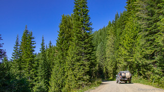
We set off again, making our way through the Clearwater National Forest. Traffic on the road - as had been the case for nearly the entirety of our trip was non-existent, allowing us the opportunity to stop here and there for photos without giving a second thought to holding anyone else up.

Armed with the absolutely beautiful book Backcountry Roads--Idaho, by Lynna Howard, we had a few extra waypoints along the Lolo - in addition to the couple provided by the BDR creators - that we decided to check out. They were of course slight detours off of the route, but even a day behind schedule, we were happy to take the time to experience the area fully.
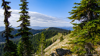
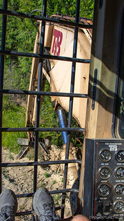
Our first of these stops was a dramatic fire lookout - the Castle Butte Lookout Tower - perched atop a pile of granite on the top of Castle Butte.


Quite clearly still in operation, there were apparently two people staffing this lookout (judging from the number of sleeping bags) but they were out exploring for the day when we made our way up to check things out. Like all lookouts, they commanded quite the view of their surroundings.


Sad to have missed a chance to hand out a few more chocolates - and hear the story of the lookout occupants - we wondered if we'd see them on the trail as we continued our trek west along the ridgeline, our elevation now varying between 5600' and 7000'. At these elevations, it was still spring, and boy were we in for a show. Some of the brightest green grass we'd seen so far, wildflowers lighting up the hillsides. Add to that the fact that - for really the first time - the forest was mostly unburned, and it was one of the most beautiful sections of the route so far!


By this time - still an hour or so before we'd need to stop for lunch - nearly half of the Lolo Motorway was behind us and we were starting to wonder if the reports we'd heard about the terrible road conditions where maybe blown just a little out of proportion. Several motorcycle riders, and a few online posts I'd read before leaving had mentioned a rocky, pot-holed mess - yet we'd covered ground here at least as fast as we had on the Macgruder.
But as we stumbled upon a pretty cool camp setup - this guy had built a really nice truck tent complete with wood heat stove - things were about to change.

I don't know if it's because the western end of the Motorway is more lightly (or heavily) traveled, or if the composition of the ground is different, or perhaps there's more/less precipitation - but the road there is clearly in much worse shape. What had been a brisk pace was suddenly slowed to 10mph or less, certain areas - of loose rock and deep potholes - even benefiting from 4Lo, as we seemingly started to inch our way along the route.

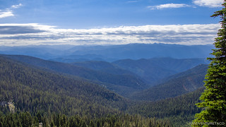
It was the perfect time for another side trip - this time to Weitas Fire Lookout. (Side note: yes, I realize that much of this trip has essentially been Fire Lookouts of Idaho as opposed to the IDBDR.)

Unlike the last several lookouts we'd visited, Weitas was unstaffed. We'd learned at Hell's Half Acre Lookout that over 90% of all US lookouts are no longer staffed, and it wasn't surprising to me that this was one of the ones that no longer supported a resident. Standing on an extremely tall wooden base, Weitas surely sways to-and-fro in the wind, not nearly as safe as some of the newer, lower lookouts that are now constructed out of concrete block.
As @mrs.turbodb prepped lunch, I ventured up the stairs - or more appropriately, ladders - to the lookout platform. It was a long climb, one that was a bit sketchy even for me - the wood creaking under my weight, my hands full with cameras, apples, water, and potato chips to round out our lunch.

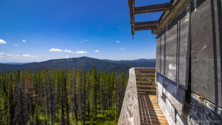
With a brisk breeze and a fair amount of rot on the top catwalk, I decided that this probably wasn't the safest place in the world to eat lunch, so I headed back down a couple levels, where I met @mrs.turbodb on her way up, sandwiches in hand. We figured that was a great place to eat - much better than 25' below, where hoards of flies were buzzing about in the mid-day sun.
Plus, it's not like the view was anything to scoff at.

Our bellies satisfied, we climbed back in the truck to make our final push to complete the Lolo by mid-afternoon - both of us ready to get onto some roads that were a bit less tooth-rattling than we'd been subjected to for the last several hours.

Still, before we were done, we had one more lookout to bag - Hemlock Butte - perched on the western-most end of the Lolo Motorway, just before it descends 2000' to it's end in the sleepy town of Pierce, Idaho. Like Wietas, Hemlock Butte is on wooden stilts - but despite that fact, it's still a staffed lookout.
So much for my theory about safety. 


Looking forward to sharing a few more stories, we called up to get permission to climb the stairs. There was no response. Strange, given that there was a pickup truck parked below the lookout, but we figured that perhaps the occupant had gone to scout the area, or fill a tub full of huckleberries - spring in full bloom here as well.

So, you can imagine our surprise when we reached the top and found the occupant sitting in the lookout, reading a book. The first one up, I apologetically asked if he minded us being there, and he shook his head no - immediately returning to reading, ignoring us completely.
I suppose that the job of fire lookout can be quite appealing to extreme introverts, as most of the time you have the entire place to yourself - and so we did our best to be quick about soaking up the views and getting out of this guys hair - snapping just a few shots, and admiring the artwork on his lookout door.


And with that and a few more miles, the Lolo was behind us! It had been an adventure for sure - taking a day longer than we expected, providing us with hardship and some of our favorite memories from the trip. It had definitely lived up to its lofty expectations.
Rolling into Pierce, we were also at the end of stage 5, with three more stages to go before we reached the Canadian border. Pierce though, was worth a stop - for two reasons. The first was fuel - we needed some, and this was the only gas station for miles. The second was a visit to the old court house - the oldest standing public building in Idaho, built in 1861.
Unfortunately, it was closed and a little plain - but hey, not all history has to be stupendously colorful!


With that, we were off - the roads now in much better shape than the Lolo, logging clearly the driving industry in these parts. We once again sped along, wide graded gravel making it easy to maintain speeds near 35mph.
Well, except for when I saw an enormous loader and just had to stop. 😀 I mean, who wouldn't want to climb up and sit in this thing?! If only I'd had the courage to turn the key and press the start button, hahahaha.

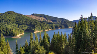
Through the woods, we made our way towards what would become our base for the evening overlooking the Dworshak Reservoir. Leased - or owned, I'm not sure - by the Potlatch Corporation, much of the land around the reservoir is quite clearly used as a tree farm - large swaths of land in various stages of growth, including several natural Christmas Tree farms.

As we drove through, I found it interesting that some parts of the forest seemed to be clear cut, while others were obviously being selectively harvested, a strategy that is surely more labor intensive, but which I prefer aesthetically.

Coming out of the forest and onto Grandad Bridge - which spans the Dworshak Reservoir - we ran into three more dual-sport riders, headed east and enjoying the blue skies and open water just as much as we were. After sharing stories of our previous few days - they'd been out on the trail for serveral as well - it was time to keep moving, our focus now on finding a spot to camp for the night.

But, finding a spot to camp in the middle of an active logging operation isn't the easiest thing in the world. Many of the spur roads were gated - likely to prevent campers from ending up too close to danger - and non-spur roads had relatively few pull-outs and with dusty gravel surfaces, would have been terrible had a logging truck barreled by.
But @mrs.turbodb had a spot she'd found on the map that she hoped would work. It appeared to be around the back side of a small knoll overlooking the reservoir, off of the main road, but not really a spur. We crossed our fingers and pushed on the 10 miles or so to check it out.
It was perfect - at least geographically. A large flat area, we had some of the best territorial views we could hope for, and little spots of water to boot. We knew as soon as we arrived that this was where we'd be spending the night.


We'd brought along a marinated steak, and this was the perfect night to eat it, along with some more of our home-grown green beans. I got to grilling as @mrs.turbodb steamed the beans, and in no time we were fighting off the flies and yellow jackets as we tried to wolf down our dinner. As great as the spot was geographically, it was a pain in the but from a fly perspective!
Of course, we had a solution for bugs - and that was to get into the tent to enjoy and evening of reading and napping - so as dinner got cleaned up, I setup and prepped the tent for occupation. It was a pleasant evening for sure, a warm breeze blowing off the lake, the suns rays casting warm light across the landscape as it fell behind the hills.


Eventually, all that was left was a glow. I'd fallen asleep at least twice already by this point, and so with one final photo I closed my eyes and listened to the coyotes howling in the distance - their hoots the perfect melody to put me to sleep.

The Whole Story
")


")
")

")


")


")
")
")
")
")


Hi Turbo,
The Castle Butte lookout is rented out to tourists during the summer months.
The Potlatch property you went through is a heavily managed tree farm of 500,000 acres in Idaho.
Thanks for the info Randy! Hope you enjoyed the story and had a chance to read the rest of the IDDDR story as well.